Issue Date: Monday, September 7th, 2020
Issue Time: 10:40AM MDT
— Flooding is NOT expected today
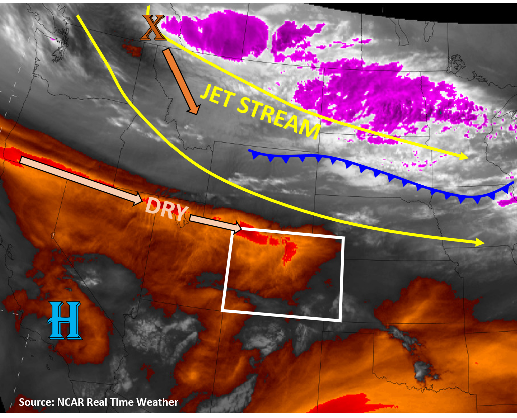
Gusty downslope winds will impact the northern Front Range through 1PM today as the jet stream dips south into Colorado today, which will keep fire danger high. Currently, wind gusts have reached over 50 mph at Berthoud Pass, and gusts over 40 mph have been reported in western Larimer County (MesoWest). The increasing pressure gradients with a southward diving trough will further increase winds for much of the central and northern mountains as the day goes on. Unfortunately, these strong winds are also co-located with dry air, as indicated by the orange/red colors on the water vapor satellite image below. With above-average temperatures across the state today, relative humidity will dip into the low teens and single digits again today. This dry air and strong winds will increase fire danger to critical levels along the Northwest Slope, Northern Mountains, and northern Front Range. The Red Flag Warning continues for these regions. The active Cameron Peak wildfire will continue to produce smoke and very poor air quality for the Front Range and Urban Corridor today. Additional smoke from fires across the US West is also infiltrating much of western Colorado this morning, which will likely hang around throughout the day.
Dry air across the state will limit chances for precipitation during the daytime today, but change is on its way. Around sunset, a strong, gusty cold front will make its way south into the plains of eastern Colorado. This cold front will increase moisture and drop temperatures rapidly overnight. Precipitation should develop over the Northern Mountains and northern Front Range by 10PM, with much of this precipitation falling as snow above 6,000 ft elevation. Up to 0.5 inches of precipitation, or around 5 inches of snow, could accumulate above 6,000 ft by 6AM tomorrow over the Northern Mountains and northern Front Range. Showers and a mix of rain and snow could bring some precipitation accumulation up to 0.3 inches to the lower elevation plains regions as well. Expect a transition from rain to snow tomorrow morning over the lower elevations. However, due to the more stratiform/stable nature of the precipitation/atmosphere behind this cold front, rain rates are expected to remain below 0.3 in/hr, so no flooding is expected. The good news is that this precipitation should help suppress and contain the ongoing wildfires.
Today’s Flood Threat Map
For more information on today’s flood threat, see the map below. Hover over the threat areas for more details, and click on burn areas to learn more about them. For Zone-Specific forecasts, scroll below the threat map.

Zone-Specific Forecasts:
Northeast Plains, Urban Corridor, Front Range, Palmer Ridge, Raton Ridge, Southeast Mountains, & Southeast Plains:
It will remain warm and dry during the day today with temperatures lower than yesterday, but still above average. Downslope winds along the Front Range have produced wind gusts up to 60 mph as well, which will allow the Cameron Peak wildfire to remain active and produce smoke across the northern Urban Corridor and Northeast Plains. A Red Flag Warning remains in place through the day today along the mountains. Details can be found from your local NWS office. A lee low pressure will develop over the Southeast Plains today, which will largely allow dry westerly winds along the western half of the plains regions and southerly to easterly winds along the eastern border. Winds gusts should stay under 30 mph over the plains. This lee low pressure will set up a dry line along the eastern border counties, separating extremely dry air from more moist air. However, a cap should prevent any storms from firing along this dryline today.
Near or after sunset, a strong cold front will begin to work its way into northern Colorado. This cold front will quickly drop temperatures into the 40Fs and 30Fs as it moves south through the eastern half of the state. The front should make its way through all of the plains regions by 6AM, and it could create wind gusts up to 60 mph with its passage overnight. Precipitation should mainly stay over the northern half of the plains regions and northern mountains by early tomorrow morning, where isolated pockets up to 0.5 inches of liquid-equivalent precipitation (up to 5 inches of snow) could fall over the highest peaks of the northern Front Range. Initially warm soils will cause some melting at first. Lower accumulations are expected over the Northeast Plains (up to 0.3 inches) with rain transitioning to snow in the morning hours. Flooding is not expected.
Primetime: 6PM to ongoing
Grand Valley, Northwest Slope, Northern Mountains, Central Mountains, Southwest Slope, San Juan Mountains, & San Luis Valley:
Temperatures will be above average again today with plenty of dry air and gusty winds ahead of the approaching system. Fire danger will be critical today for the Northwest Slope and Northern Mountains, where westerly wind gusts up to 40 mph and relative humidity in the single digits are expected.
A strong cold front will work its way into northern and eastern Colorado as a trough moves south over Colorado, but this surface front will have issues getting over the high terrain. The slower moving front will likely work its way into the Northern Mountains and Northwest Slope by early morning. The front will quickly drop temperatures for northern valley locations to near or below freezing, and some showers could bring up to 5 inches of snow to high elevation locations of the Northwest Slope and Northern Mountains by tomorrow morning. Precipitation may start as rain initially for lower elevation locations of the Northwest Slope. No flooding is expected, but the precipitation should start to increase south as the front pushes through.
Primetime: 6PM to ongoing