Issue Date: Thursday, September 3rd, 2020
Issue Time: 09:40AM MDT
— Flooding is NOT expected today
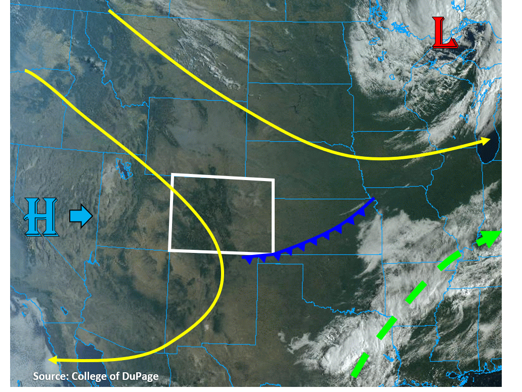
A cold front made its way south along the plains of eastern Colorado this morning, which brought brief gusty winds up to 40 mph. This front does not have much moisture with it, as dew points behind the front are in the 30Fs, so it will not increase precipitation chances today. The true color satellite image below shows there aren’t any clouds associated with the cold front, indicating the limited moisture. In fact, the front is pushing higher surface moisture out of the area in the Southeast Plains, where dew points were in the low 50Fs earlier this morning. The front will act to keep high temperatures slightly cooler today along the plains, but not by much. Above average temperatures will continue along the western slope. Stronger upper-level flow will shift east today between the broad trough over the Great Lakes and the eastward building high pressure ridge over the West Coast (see image below). This will act to weaken pressure gradients over Colorado, so weaker surface winds are forecast, which will lower the fire danger. Northwest flow over northern Colorado is pushing some smoke from the Cameron Peak wildfire into the northern Urban Corridor and lowering air quality. Other than some smoke back in the forecast, most of Colorado will see clear and dry weather today. No flooding is expected.
Today’s Flood Threat Map
For more information on today’s flood threat, see the map below. Hover over the threat areas for more details, and click on burn areas to learn more about them. For Zone-Specific forecasts, scroll below the threat map.

Zone-Specific Forecasts:
Northeast Plains, Urban Corridor, Front Range, Palmer Ridge, Raton Ridge, Southeast Mountains, & Southeast Plains:
A passing cold front will cool temperatures down by a tick or two today, but limited moisture behind this front and stable conditions will keep precipitation chances near zero. Expect clear skies once again today, so no flooding is expected. Some smoke may lower air quality for the northern Urban Corridor, but current Colorado wildfires are not producing large amounts of smoke due to increased containment.
Grand Valley, Northwest Slope, Northern Mountains, Central Mountains, Southwest Slope, San Juan Mountains, & San Luis Valley:
Mostly sunny and warm today, with high temperatures getting into the low 90Fs for the Grand Valley and Southwest Slope. A few mountaintop, fair weather clouds could pop up with diurnal heating, but no measurable precipitation is expected today. Winds along the Northern Mountains should be weaker today, so fire danger is lower. However, spark-producing activities should still be avoided due to low relative humidity and dry fuels.