Issue Date: Sunday, August 30th, 2020
Issue Time: 10:00AM MDT
Summary:
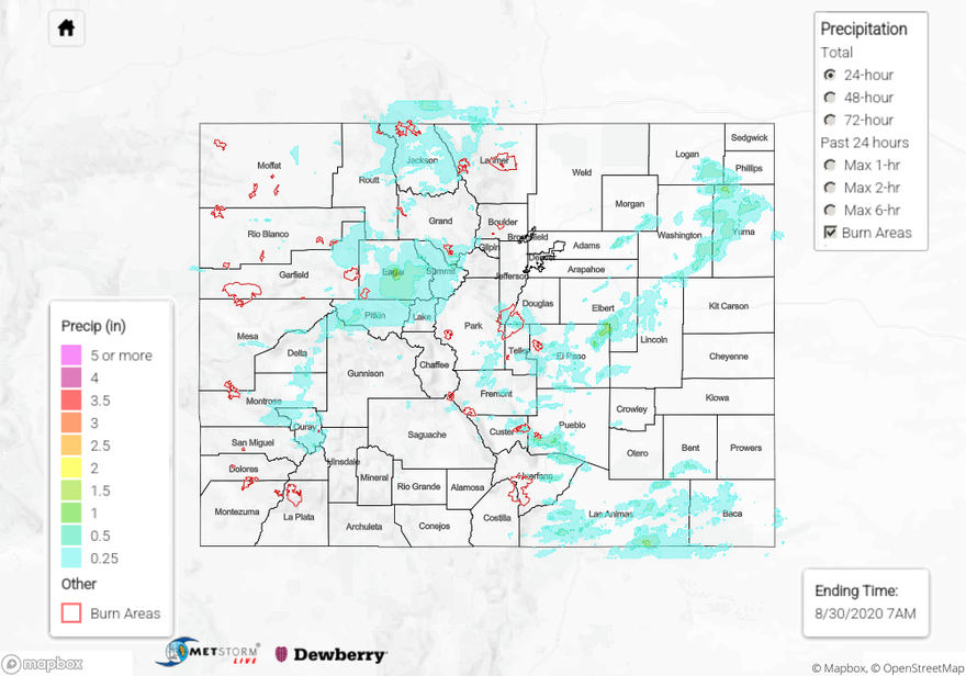
Morning showers and some weak afternoon storms produced a healthy accumulation of rain over the mountain regions, with several locations picking up over 0.5 inches of rain from the northern San Juan Mountains north through the Central and Northern Mountains. The highest CoCoRaHS rain gauge report was 0.65 inches near I-70 just east of Vail in Eagle County. A couple of 2”+ reports were submitted in Eagle County, but they likely are erroneous measurements as a nearby report only shows 0.3 inches. Note that this has created erroneously high QPE values for Eagle County on the QPE map below. Some gusty winds were also reported with the afternoon storms that moved through the northwest part of the state, with gusts up to 64 mph. This wind was likely due to some drier air that moved into that area causing more evaporation.
As the shortwave moved off the mountains into the plains of eastern Colorado, it produced some heavy downpours with a north-south oriented band of storms that propagated to the eastern border. These storms produced up to 1.42 inches of rain just south of the town of Simla according to CoCoRaHS rain gauges. Up to 0.79 inches of rain also fell over the Colorado Springs area. This caused a rapid rise in flow in Fountain Creek, from 35 cfs to 455 cfs at the stream gauge in Colorado Springs. A bit further south in eastern Custer County, a debris slide closed highway 96 near the Junkins burn area (from 2016). A heavy rain report of 0.55 inches was sent in near the area, and some small hail was reported farther southeast in Pueblo County. In the town of Yuma (Northeast Plains), 0.83 inches of rain was reported in 20 minutes, which caused some minor flash flooding of paved roads.
Ongoing large fire update (as of 10:00 AM on InciWeb):
Pine Gulch – north of Grand Junction: 139,006 acres; 77% contained (Colorado’s LARGEST WILDFIRE)
Grizzly Creek – Glenwood Canyon: 32,464 acres; 73% contained (minimal growth, increased containment)
Cameron Peak – Medicine Bow Mountains: 23,007 acres; 0% contained
Williams Fork – Arapaho National Forest: 12,097 acres; 10% contained (minimal growth, increased containment)
To see how much rain fell near you over the last 24 to 72 hours, check out our State Precipitation Map below.
Click Here For Map Overview