Issue Date: Thursday, August 20th, 2020
Issue Time: 10:30AM MDT
— Flooding is NOT expected today
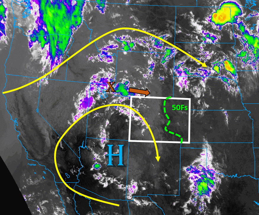
Colorado’s weather is once again dominated by the persistent high pressure ridge, which has shifted its center slightly southeast into northern Arizona today (see image below). The trough over the Pacific Northwest continues to squish the amplified ridge south, which will cause more westerly upper-level flow over western Colorado today. A piece of shortwave energy is circulating around the high pressure, currently over northern Utah (“X” in IR satellite image below), which will work its way into northern Colorado today. This mid-level energy will help storms to fire over the northern tier of the state this afternoon, finally increasing chances for some rainfall over the parched Northwest Slope. Upper-level flow is quite strong over northern and eastern Colorado today, so storms should move fairly quickly today, reducing the chances for flooding.
This morning’s soundings show that plenty of mid-level moisture is still present over the state, but surface moisture is limited. The highest surface moisture is over the plains of eastern Colorado this morning, where most locations are seeing dew points in the 50Fs, as indicated on the image below. However, weak upslope flow today will not reinforce this moisture for all but the southeast corner of the state. In fact, northerly surface winds along the Urban Corridor and southeasterly surface winds over the Southeast Plains will favor a convergence zone along the Palmer Divide today. With the passage of the shortwave, storms will initially fire over the high terrains and northwest corner of the state. Storms are likely to fire across most mountain regions of western Colorado, but the Southwest Slope will see the lowest chances for storms. Storms will then move east into the plains, where stronger upper-level flow and better surface moisture could allow some storms to grow more up-scale, especially near the expected Palmer Ridge convergence zone. The storms over the plains have the highest chances of dropping wetting rainfall, but fast storm motions will keep the flood threat reduced. No flooding is expected today.
Diurnal heating today will again mix out the limited surface moisture, which will cause inverted V profiles and increase chances for strong outflow winds with storms. This will increase the fire danger today, as these winds could cause more rapid spread of the current wildfire boundaries, like what happened to the Williams Fork and Pine Gulch fires yesterday. A Red Flag Warning is in place across all of western Colorado and even the Front Range for today because of the chance of dry lightning and gusty storm outflow winds.
Today’s Flood Threat Map
For more information on today’s flood threat, see the map below. Hover over the threat areas for more details, and click on burn areas to learn more about them. For Zone-Specific forecasts, scroll below the threat map.

Zone-Specific Forecasts:
Northeast Plains, Urban Corridor, Palmer Ridge, Raton Ridge, & Southeast Plains:
Storms should move off the higher terrain into the plains regions by early afternoon, causing brief heavy downpours and gusty outflow winds up to 60 mph. Storms may grow larger in scale as they work their way southeast. The highest chances for storms are over the southern Urban Corridor and Palmer Ridge, where a convergence boundary is likely to set up today. The highest rain rates will likely be over this area and into the Southeast Plains, where up to 0.8 inches of rain could fall in an hour. Storms should move fairly quickly to the southeast at 20-30 mph, so no flooding is expected from these storms. Showers and storms could linger well into the night.
Primetime: 1PM to 2AM
Grand Valley, Northwest Slope, Northern Mountains, Front Range, Central Mountains, Southwest Slope, San Juan Mountains, Southeast Mountains, & San Luis Valley:
Numerous high-based thunderstorms will develop over the high terrains this afternoon and quickly move east/southeast. A passing shortwave over northern Colorado will increase chances for storms over the Northwest Slope today, which has seen little rainfall lately. Rain rates from these high-based storms should stay below 0.3 in/hr for western regions, but rain rates up to 0.5 in/hr are possible over the southern Front Range, where increased moisture exists. Limited surface moisture and fast storm motions (20-30 mph) means flooding is not expected today. However, a strong storm moving over a burn scar could still cause issues, so be cautious.
The larger threats are the strong outflow winds up to 55 mph and dry lightning possible with these storms, as weak surface moisture will favor plenty of sub-cloud evaporation. This will increase the fire danger today. A Red Flag Warning is in place for all regions, except for the Southeast Mountains and San Luis Valley. Additionally, the Southwest Slope and Grand Valley will once again see very warm temperatures near the century mark, potentially breaking records for a third day in a row for Grand Junction.
Primetime: 12PM to 12AM