Issue Date: Tuesday, August 18th, 2020
Issue Time: 10:00AM MDT
— Flooding is NOT expected today
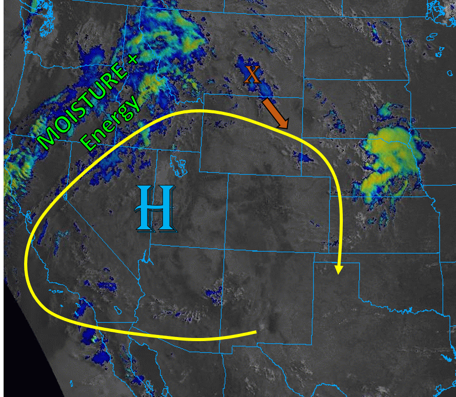
This morning’s visible + IR satellite image (see below) shows very little clouds over Colorado as most of the moisture and energy is being circulated around an amplified high pressure ridge and directed into the Northwest US. Mid-level and upper-level flow is stronger near the yellow line in the graphic below, with weak steering flow on the interior of this ridge. This is causing very weak winds and no upper-level energy to impact western Colorado today. Far eastern Colorado is just barely being grazed by stronger mid- and upper-level flow, and weak upper-level energy over eastern Montana should rotate around the high pressure ridge and cause some extra lift over the plains.
Surface dew points are in the 30Fs and 40Fs for most plains locations in eastern Colorado this morning, and PW has decreased slightly in the Denver sounding, so thinking this mid-level energy will produce only mid to upper level cloud cover and little rainfall. Better low-level moisture will be to our east where more southerly surface winds will be located. With limited moisture, strong diurnal heating, and limited cloud cover today, temperatures will rise to near record values for most plains locations. The high-based storms that form today should mainly fire over the higher terrain, but all storms that develop will produce more wind that rainfall. Flooding is not expected with today’s storms.
Today’s Flood Threat Map
For more information on today’s flood threat, see the map below. Hover over the threat areas for more details, and click on burn areas to learn more about them. For Zone-Specific forecasts, scroll below the threat map.

Zone-Specific Forecasts:
Northeast Plains, Urban Corridor, Palmer Ridge, Raton Ridge, & Southeast Plains:
Mostly sunny skies will allow temperature to soar to near record values, likely approaching the century mark. Weak storms may dissipate over the Urban Corridor as they drift off the higher terrain to the west, but no rain accumulation is expected, likely just some gusty winds up to 45 mph. Additionally, some weak storms may move into the Northeast Plains and fire over portions of the eastern Palmer Ridge and eastern Colorado border with upper level support. These eastern storms could have rain rates up to 0.3 in/hr if they’re able to break the fairly strong cap in place. No flooding is expected from these storms, but some gusty outflow winds are likely.
Primetime: 1PM to 9PM
Northern Mountains, Front Range, Central Mountains, San Juan Mountains, San Luis Valley, & Southeast Mountains:
Clouds and storms will form over the high terrain this afternoon and drift south, but rainfall will likely only be able to make it to the ground over the higher elevations. Higher moisture exists in the southern mountains, where dew points are in the 30Fs and 40Fs. Lower moisture exists in the northern mountains. Max rain rates with these high-based storms over the northern mountain regions will stay below 0.1 in/hr, with rain rates up to 0.2 in/hr in the southern mountain regions. Some gusty outflow winds are possible with the stronger storm cores, but no flooding is expected.
Primetime: 1PM to 9PM
Grand Valley, Northwest Slope, & Southwest Slope:
It will remain hot and dry today, with no precipitation expected. High temperatures will approach record levels with abundant daytime heating. Expect continued wildfire smoke to impact air quality and potentially prevent record temperatures for locations under the thickest smoke.