Issue Date: Sunday, August 16th, 2020
Issue Time: 10:05AM MDT
Summary:
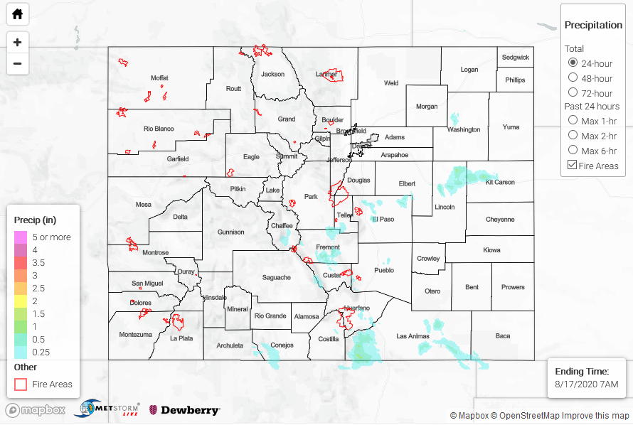
Upslope flow storms began to fire just after 1PM near the southern border with storms popping over the Palmer and Raton Ridge between 3:30 and 4PM. Storms that fired in Conejos County produce 24-hour totals around 0.45 inches. Over the Palmer Ridge, storms produce more hail than rain with reports of hail size near the Colorado Springs area ranging from 0.75 inch to 2 inches (Peterson AFB). Storm totals were just under 0.5 inches according to USGS and CoCoRaHS reports in the area. A complex of storms over Fremont County produced up to 0.75 inches. A storm tracked over the southern edge of the Spring Creek burn area around 3:30 PM, and mud flows and flash flooding were reported across Highway 12. This seems to be the most sensitive part of the burn area as a Weather Underground gauge recorded only 0.25 inches of rain. Extra convergence along the Raton Ridge and a couple rounds of storms help totals reach just over 1 inch.
Stronger storms developed over the eastern plains in the evening hours where better parameters existed for storms to become severe. They had trouble breaking the cap that was in place, but the storms that did form dropped some heavy rainfall and large hail. A storm in Washington County produce a weak tornado (landspout) that lasted 2 to 3 minutes just after 5:30PM. This same storm produced 2 inch hail (hen egg) and rainfall totals just over 0.50 inches. A stronger storm complex in Kit Carson and Lincoln County produced totals just over 1 inch and hail up to 1.75 inches. MRMS QPE has totals up to 1.75 inches and AHPS QPE has totals just under 1.5 inches, so the truth is probably somewhere in the middle. A gauge north of Genoa recorded 0.53 inches. Flooding was not reported with these storms yesterday.
Quick fire update:
Pine Gulch – north of Grand Junction: 76,183 acres; 7% contained (will likely move to the 4th largest in the state’s history over the next few days)
Grizzly Creek – Glenwood Canyon: 25,690 acres; 0% contained
Cameron Peak – Medicine Bow Mountains: 10,867 acres; 0% contained
Williams Fork – Arapho National Forecast: 4,300 acres; 0% (+ ~3,000 acres in 1 day)
To see precipitation estimates over your neighborhood the last 72-hours, scroll down to the State Precipitation Map below.
Click Here For Map Overview
Note: The 24-hour, 48-hour and 72-hour total precipitation do not contain bias corrections today due to errors in the CoCoRaHS data. This means there may be underestimations in QPE over the southwest and southeast corners of the state.
