Issue Date: Sunday, August 16th, 2020
Issue Time: 9:20AM MDT
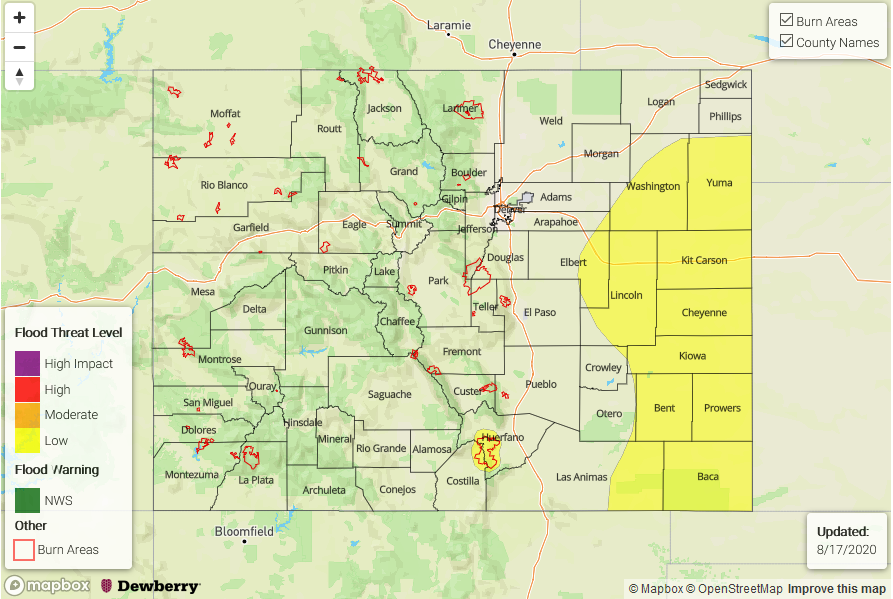
— A LOW flood threat has been issued for the Northeast Plains, Southeast Plains, eastern Palmer Ridge, and eastern Raton Ridge. This threat also includes the Spring Creek burn area.
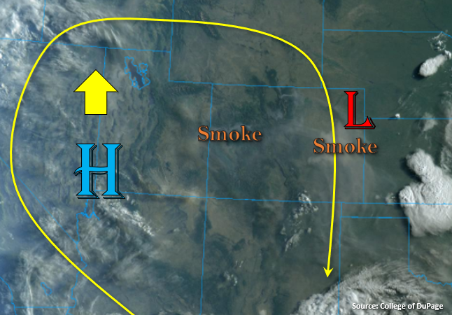
Lots of smoke is still trapped under the ridge, and it’s very widespread and thick over the eastern plains (marked below). The High will continue to strengthen over the Great Basin today, which will keep high temperatures on the rise over the western half of the state and hot temperatures in the forecast statewide. It’s still pretty dry over the western slope and Northern/Central Mountains, as seen by the cloud free conditions, so precipitation chances will continue to be near zero. A little moisture looks like it will combine with some mid-level energy over the San Juan Mountains, so expect another round of high-based showers over the eastern/southern San Juan Mountains this afternoon with slightly higher totals when compared to yesterday.
Over the Southeast Mountains, chances for precipitation also increase today. The slow-moving storms will be capable of producing isolated totals around 0.75 inches, which could be problematic if one forms over the Spring Creek burn area, so a Low flood threat has been issued. About a quarter of an inch fell yesterday on the southern portion of the burn area (gauge observation), which caused flash flooding and a debris flow onto Highway 12. This seems to be the most sensitive area of the scar.
A convergence boundary (weak cold front) will set up over the eastern plains and Raton Ridge this afternoon, which could spark some isolated storms. Less shear and a lack of a noticeable shortwave moving through the flow today means that storm coverage will be less and storms should be weaker when compared to yesterday. However, the slow steering winds will still allow the smaller storm cores to drop some heavy rainfall if they can break through the cap. Thus, the Low flood threat has been re-issued with dew points forecast in the 60Fs and PW just over 1 inch. Rainfall should start to end a couple hours after sundown.
Today’s Flood Threat Map
For more information on today’s flood threat, see the map below. If there is a threat, hover over the threat areas for more details, and click on burn areas to learn more about them. For Zone-Specific forecasts, scroll below the threat map.
Zone-Specific Forecasts:
Front Range, Urban Corridor, Palmer Ridge, Southeast Mountains, Northeast Plains, Southeast Plains, San Luis Valley, & Raton Ridge:
Upslope flow will cause more widespread storms to form over the Southeast Mountains today, and southerly steering flow could push a few storms into the San Luis Valley where morning totals up to 0.25 inches will be possible. Isolated totals over the Southeast Mountains could reach 0.75 inches, so a Low flood threat has been issued for the Spring Creek burn area. More isolated storms are forecast over the Palmer Ridge and southern Front Range with totals up to 0.90 inches possible. Storms that move south, just off the foothills, could produce some severe hail again as well. Further north, a storm or two could form over the northern Front Range, but rain rates should remain around 0.50 inches with no rainfall again for the Denver Metro area.
Over the eastern plains, expect some more intense storms as parameters are more favorable with the stronger southeasterly surface winds. Still a chance a few storms could become severe that form along the convergence boundary, but the threat is lower than yesterday. The main threats from the severe storms that develop include heavy rainfall, large hail, and damaging outflow winds. A weak tornado could also be possible with extra spin along the front. With max 1-hour rain rates up to 1.75 inches possible, a Low flood threat has been issued.
Primetime: 1:30PM to 11PM
San Juan Mountains, Central Mountains, Northern Mountains, Southwest Slope, Northwest Slope, & Grand Valley:
Looking like there’s still some mid-level moisture over the eastern/southern San Juan Mountains. This will spark another round of storms and some mid-level energy could help slightly increase totals and coverage when compared to yesterday. Isolated, totals up to 0.40 inches will be possible. Dry everywhere else with hot temperatures forecast again. Warmer temperatures near surface in today’s Grand Junction sounding and the HRRR Smoke indicate the smoke will take longer to mix out, so expect less near surface visibility with poor air quality.
Primetime: 1:30PM to 8PM