Issue Date: Saturday, August 15th, 2020
Issue Time: 10AM MDT
Summary:
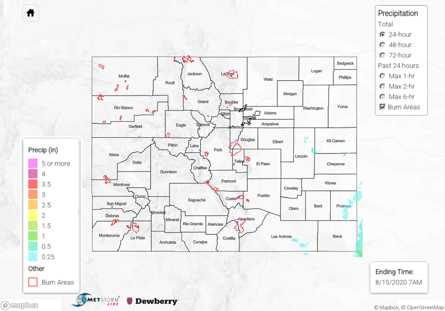
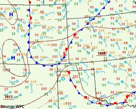
Quite a remarkable moisture boundary set up near the surface Low yesterday afternoon. The surface map below shows dew points in green. So back to the west and over the mountains dew points were in the low teens to mid 30Fs, which is very dry. As you moved east, dew points rose into the 50Fs over the Northeast Plains. Typically, 55F is about what you need to generate a severe thunderstorm. Over the far southeast corner, dew points around the Low ranged from 39F (west) to 55F (north) to 70F (east). This gradient in moisture is what lead to the severe thunderstorm over Kansas (partially shown below) dropping around 2 inches in its core compared to the severe thunderstorm over Prowers County dropping under a half of inch of rainfall in its core. The storm over Kansas was in the Cimarron National Grasslands, so not many observations except a 0.78 inch CoCoRaHS report near the OK/KS/CO border. However, with dew points this high, and a nearly stationary storm, the higher totals are more believable. Cimarron River near Elkhart also showed a slight spike in the stream gage. Hail 2 inches in diameter (hen egg) was also reported with the left-splitting storm over Prowers County. Rainfall totals were under 0.25 inches from the storms that formed over the southern and eastern San Juan Mountains. Lastly, early this morning, some convection was generated over the Raton Ridge, and QPE was estimated at 0.5 inches. Flooding was not reported as of this morning for any of the storms yesterday.
Quick fire update:
Pine Gulch – north of Grand Junction: 74,702 acres; 7% contained (now the 5th largest in the states history)
Grizzly Creek – Glenwood Canyon: 19,440 acres; 0% contained
Cameron Peak – Medicine Bow Mountains: 5,424 acres; 0% contained
Williams Fork – Arapho National Forecast: 1,300 acres; 0% (new fire)
To see precipitation estimates over your neighborhood the last 24 to 72-hours, scroll down to the State Precipitation Map below. Again, the precipitation generated over Lincoln County is an artifact of the wind turbines in the area.
Click Here For Map Overview