Issue Date: Saturday, August 15th, 2020
Issue Time: 9:15AM MDT
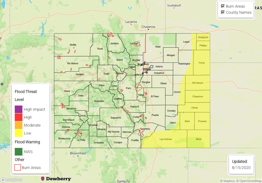
— A LOW flood threat has been issued for the Raton Ridge, Northeast Plains, Southeast Plains, and eastern Palmer Ridge
The High has shifted west and will start to build northward later today and into tonight, which will start to give the upper flow more of a northerly component over the state. This is especially true over eastern Colorado. Dry air will continue to dominate the majority of the state with PW measured at 0.39 inches in Grand Junction this morning, so this will keep precipitation chances low to nil over western Colorado and most of the high terrains. At the surface, more southeasterly and easterly surface winds are expected over the eastern plains and southern border due to a surface High over the High Plains, which will pull in some higher low-level moisture. Over the Front Range and Urban Corridor, expecting more of a drying, northwesterly surface wind. Paired with more westerly upper flow (also drying), the Front Range and Urban Corridor should stay dry today.
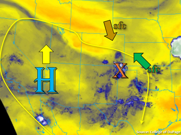
The combination of the surface winds will help set up a convergence boundary further east, which could initiate some severe thunderstorms this afternoon and evening over the plains. With more northerly steering winds and a shortwave moving around the ridge helping to spark and maintain convection, the storms could drop some heavy rainfall as they move south. It also looks like a moderately strong low-level jet could aid in keeping the convection going into the late hours of the night. Additionally, stronger upslope flow over the Southeast Mountains, Raton and Palmer Ridge should generate some additional storms, and as the storms move off the mountains, they will be capable of producing some heavier rainfall. A Low flood threat has been issued for the plains as well as over the Raton Ridge where extra convergence will give a better chance for some higher rainfall totals.
Today’s Flood Threat Map
For more information on today’s flood threat, see the map below. If there is a threat, hover over the threat areas for more details, and click on burn areas to learn more about them. For Zone-Specific forecasts, scroll below the threat map.
Zone-Specific Forecasts:
Palmer Ridge, Southeast Mountains, Northeast Plains, Southeast Plains, & Raton Ridge:
These areas will have the higher moisture this afternoon and evening, giving them the best chance for some rainfall. Isolated, heavier rain will be possible over the Raton Ridge/Southeast Mountain intersect and slightly east with extra convergence along the ridge. Max 1-hour rain rates up to 1.2 inches will be possible, so a Low flood threat has been issued. Over the Southeast Mountains, rain rates up to 0.25 inches will be possible.
Severe thunderstorms over the eastern plains today and tonight could produce max 1-hour rain rates up to 2.75 inches. Some of the guidance is showing convection staying more isolated, but if the convection can become upscale tonight (MCS), that’s when the higher rain rates should be expected. Slightly better chances for these higher rain totals over the Southeast Plains, but if storms can break the cap over the Northeast Plains, early this evening, rain rates up to 1.9 inches will be possible. There is also a threat for very large hail and damaging outflow winds with the severe storms that develop. A Low flood threat has been issued.
Primetime: 1PM to 3AM
Front Range, Urban Corridor, San Juan Mountains, Central Mountains, Northern Mountains, Southwest Slope, Northwest Slope, Grand Valley, & San Luis Valley:
It should stay mostly dry in the regions today with temperatures rising a couple degrees. There’s still some upper-level moisture over the San Juan Mountains (blue in the water vapor imagery), so some high-based storms will be possible further east and south. The main threat will be gusty outflow winds with only isolated measurable rain possible (under 0.10 inch totals). Air quality will stay low, especially with another fire starting in Grand County yesterday. The more northerly flow aloft will help push some of the smoke further south. With the dry and hot conditions, fire growth is still expected today.
Primetime: 1PM to 8PM