Issue Date: Friday, August 14th, 2020
Issue Time: 8:05AM MDT
— Flooding is NOT expected today
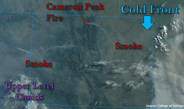
There’s quite a bit of smoke across the state this morning, along with a new fire near Fort Collins highlighted in the visible satellite imagery below. Daytime heating will once again help mix out some of the smoke, so expect visibility to improve slightly from late morning into the afternoon. The eastward moving tough, to our north, will drop a cold front through eastern Colorado this morning, but it will be more of a wind shift than cooling feature. Not much moisture accompanying it either, so the weak upslope flow that occurs behind it this afternoon won’t produce much, if any, precipitation. The best chance for a thunderstorm or two will be over the far Southeast Plains where a convergence boundary sets up with a surface low. If storms form in the area, they will quickly move into Kansas where better storm parameters will exist for severe thunderstorm development. There is also a chance for some light rainfall over the eastern San Juan and Southeast Mountains. Some mid-level moisture, marked by the cloud cover below (purple), has worked its way in across the southern border. Isolated showers that do form will be high-based and produce more wind than rainfall, so flooding is not forecast today.
Today’s Flood Threat Map
For more information on today’s flood threat, see the map below. If there is a threat, hover over the threat areas for more details, and click on burn areas to learn more about them. For Zone-Specific forecasts, scroll below the threat map.

Zone-Specific Forecasts:
San Juan Mountains, San Luis Valley, Southeast Mountains, Southeast Plains, & Raton Ridge:
Some upper level moisture has moved northwards across the southern border. This will help spark some isolated showers and cloud cover over the high terrains today. Isolated storm totals up to 0.15 inches will be possible, but most storms will produce only gusty outflow winds and sprinkles. A stronger storm or two could form over the Southeast Plains along a surface convergence boundary before quickly crossing into Kansas. Max 1-hour rain rates up to 1.20 inch will be possible. Flooding is not forecast today.
Primetime: 1PM to 10PM
Front Range, Urban Corridor, Northeast Plains, & Palmer Ridge:
As the High to our south begins to move westward today and tonight, the plume of smoke is expected to shift with it. Upper level winds gain more of a northerly component tonight, so areas to the south should expect a little more smoke in the overnight hours and by Saturday morning. With the new fire in Fort Collins, not sure the wind shift will bring relief from the smoke to the Urban Corridor. It’ll be too dry for any rainfall this afternoon, but some broken cloud cover should still be able to form. Winds might slightly increase from the north as the front drops south, but the stronger winds should stay over the far eastern plains.
Central Mountains, Northern Mountains, Southwest Slope, Northwest Slope, & Grand Valley:
It will remain dry again this afternoon. Some mid-level energy should mix with the slight increase in upper level moisture bringing more cloud cover and possibly a weak shower to the inner mountains. Stronger wind speeds will likely mix down to the surface again. However, with the trough to east, the pressure gradient (and associated wind) should decrease on the large-scale. While fire danger is still high with the dry fuels and low relative humidity values, a general decrease in surface winds means that no Red Flag Warning has been issued.