Issue Date: Tuesday, August 11th, 2020
Issue Time: 8:50AM MDT
— Flooding is NOT expected today
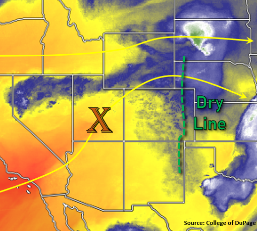
Increasing west-southwest flow aloft today will continue to entrain the dry air mass over the majority of the state (yellow/orange below). This will produce lower precipitation chances back to the west and over the mountains. Additionally, the dry air is expected to move into the adjacent, eastern plains helping mix out surface moisture from west to east, which will set up a dry line over the eastern border counties. Along and east of this line will be the main focus for heavier rainfall this afternoon and evening, and upper dynamics are favorable for a few severe thunderstorms to develop. Expect the haze to continue as well over northern Colorado with the ongoing fire activity.
A weak shortwave is also expected to move through the flow, which will help enhance lift and increase wind speeds as it moves overhead. Without much surface moisture to work with, “storms” that can fire back to the west will likely produce strong outflow winds and little to no rainfall. The increased wind speeds from the feature are also expected to somewhat mix down to the surface, which will escalate fire danger with the low relative humidity values over western Colorado. A Red Flag Warning has been issued for the western border counties and Central Mountains from noon to 8PM. As the shortwave arrives to the eastern plains this afternoon, it will help kick off the convection. Severe thunderstorms that develop will be capable of producing strong wind gusts and severe hail. PW values will be around 1 inch, but faster steering flows to the east/southeast and more scattered coverage of the stronger storms means that no flood threat will be issued.
Today’s Flood Threat Map
For more information on today’s flood threat, see the map below. If there is a threat, hover over the threat areas for more details, and click on burn areas to learn more about them. For Zone-Specific forecasts, scroll below the threat map.

Zone-Specific Forecasts:
Front Range, Southeast Mountains, Urban Corridor, Southeast Plains, Northeast Plains, Palmer Ridge, & Raton Ridge:
Temperatures will be back on the rise today after a nice cool down over portions of eastern Colorado yesterday. Rainfall chances are close to zero over the mountains and I-25 corridor, although areas with increased cloud cover this afternoon over the mountains may see a sprinkle or two. As the clouds move off the mountains into the adjacent plains, the breeze should pick up. Best chance for rainfall will be over the border counties along and east of a dry line. Max 1-hour rain rates up to 1.4 inches will be possible along with strong wind gusts (up to 55 mph) and large hail (up to 1.5 inches) for the severe storms that develop. Faster storm motion and smaller coverage of the heavier rain cores will mean that no flood threat is issued.
Primetime: 2PM to 9PM
San Juan Mountains, Central Mountains, Northern Mountains, Southwest Slope, Northwest Slope, Grand Valley, & San Luis Valley:
High fire danger is forecast today with a Red Flag Warning issued for the border counties and Central Mountains from noon to 8PM. Southwest surface winds are forecast to be between 10 and 20 mph with gusts up to 30 mph possible as relative humidity values continue to sit in the low teens and single digits. Haze is expected to continue and the HRRR model shows a lot of near surface smoke over the Grand Valley and portions of the Central Mountains, which will lower the air quality. Hot temperatures are also forecast with the Grand Valley reaching the upper 90Fs, Durango near 90F, and the mountain valleys in the mid to upper 70Fs. Again, the dry air will keep precipitation chances near zero.