Issue Date: Thursday, August 6th, 2020
Issue Time: 11:00AM MDT
Summary:
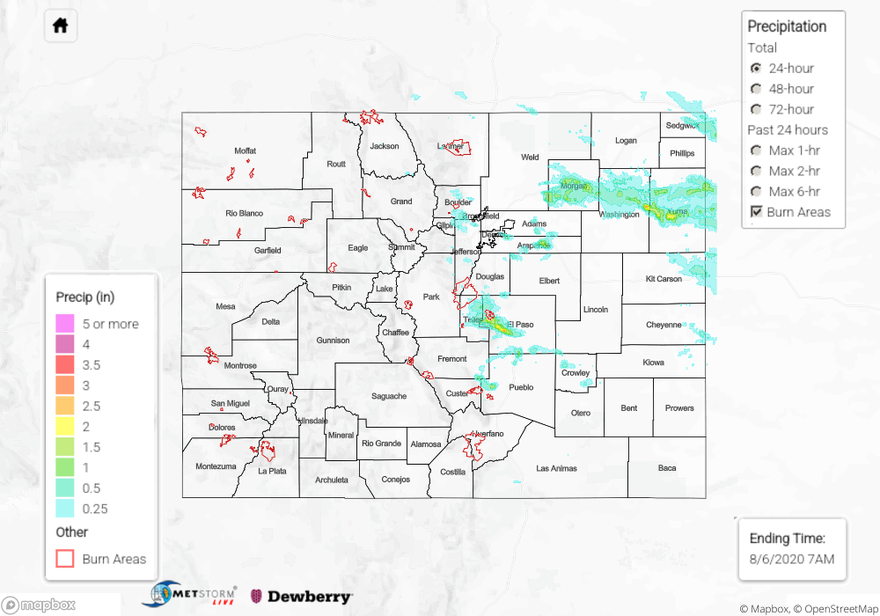
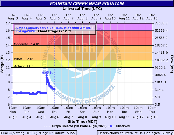
Heavy rain and accumulating hail occurred over the Colorado Springs area yesterday as storms re-generated over the higher terrain west of the city and trained east over the area between 3PM and 9PM. Hail as large as 2 inches in diameter was reported to have caused damage to cars & windows and even accumulated enough to cover Interstate 25. Heavy rain up to 2.14 inches was reported by CoCoRaHS observers. A USGS rain gauge northwest of Manitou Springs reported 2.13 inches of rainfall, and four nearby USGS gauges reported over 1 inch of rain. The QPE map shows this heavy rainfall over western and southern parts of Colorado Springs, which indicates up to 3 inches fell over the 24 hour period. The Fountain Creek gage downstream of this heavy rainfall observed a rapid jump in gage height and 50-fold increase in flow from 70 cfs to 4000 cfs (see hydrograph below). Fountain Creek remains at streamflow levels above the 90th percentile near Pueblo as of this morning. Fortunately this heavy rainfall was not enough for the creek to reach flood stage, but flooding of roadways was reported in the Colorado Springs area. This flooding caused a debris slide near Manitou Springs and even caused cars to stall out near Fountain.
A cluster of more organized severe storms moved through Morgan, Washington, and Yuma counties yesterday, dropping up to 2.5 inches of rain according to the QPE map. CoCoRaHS observers reported up to 1.66 inches of rainfall from these severe storms, with near or over 1 inch reported in each county. A social media report indicated 2.5 inches of rain fell south of Yuma, CO, which is near where the QPE indicates the higher rain totals from these storms. Hail up to 0.88 inches in diameter and strong winds up to 63 mph also accompanied these storms. Flooding was not reported over this rural area as of this morning.
The Pine Gulch Fire north of Grand Junction grew quite a bit yesterday, up to around 12,000 acres as of late last night, and is only 5% contained. Unfortunately, continued dry and windy weather will continue over western Colorado today. Keep up to date on conditions and warnings from NWS Grand Junction if you live near the area.
For rainfall estimates in your area over the last 24, 48, and 72 hours, check out our State Precipitation Map below.
Click Here For Map Overview