Issue Date: Thursday, August 6th, 2020
Issue Time: 10:00AM MDT
— A LOW flood threat has been issued for portions of the Northeast Plains, Palmer Ridge, and Southeast Plains
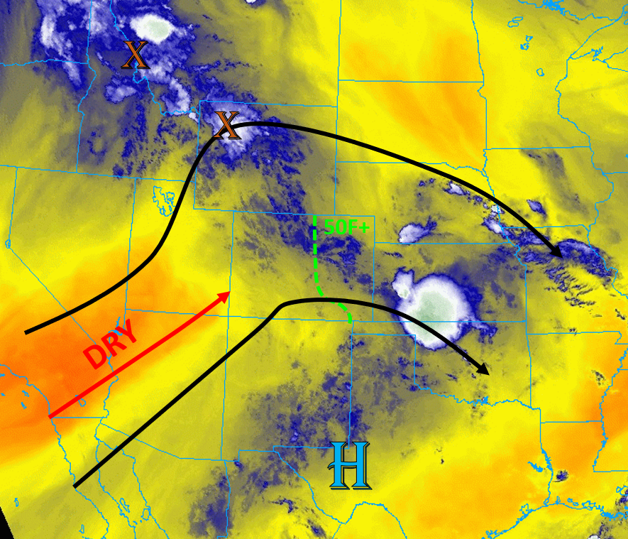
Colorado is still sitting under the ridge today, but the axis has shifted slightly east. Leftover moisture and energy are lingering at mid-levels, as seen by the blue colors in the water vapor image this morning and showers over the Palmer Ridge (see below). Low-level moisture is still present east over the plains, with dew points in the 50Fs and 60Fs along the eastern border (green line). However, this morning’s sounding at Denver shows decreasing PW values compared to yesterday (0.82 inches), so thinking coverage of rainfall will be a bit less as this is forecast to continue to decrease. Residual low-level moisture will allow for another round of storms to track over the plains, but less severe weather is forecast due to lower wind shear values. Also, a lee, surface low is expected to develop over the western Southeast Plains, which will only support moist southeasterly flow for the eastern portion of the plains. This will help keep the higher dew points in place, but dry downslope winds will likely help to scour out surface moisture along the southern Front Range, Raton Ridge and Southeast Mountains. Therefore, very low chances for rainfall in these areas today. As storms move east during the afternoon, they will encounter better moisture, so some strengthening should occur. Upper-level flow is weaker today over the plains, so storms will produce slightly higher rainfall totals since they will be moving slower. Since there exists a chance for some heavy rainfall cores over the plains, a Low flood threat has been issued for the Northeast Plains, Palmer Ridge, and Southeast Plains.
Very dry air is moving its way into western Colorado with the southwest flow, which is evident on the water vapor image this morning (orange/yellow). This dry air will limit storms over the mountains and western slope today, and an incoming trough will help increase the pressure gradient. This will cause an increase in winds, and with dry fuels, fire danger will also increase. A Red Flag Warning has been issued for the western portion of the state, and you can follow your local NWS office for the latest.
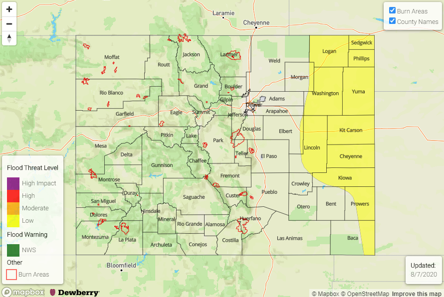
Today’s Flood Threat Map
For more information on today’s flood threat, see the map below. Hover over the threat areas for more details, and click on burn areas to learn more about them. For Zone-Specific forecasts, scroll below the threat map.
Zone-Specific Forecasts:
Northeast Plains, Southeast Plains, Palmer Ridge, Urban Corridor, Front Range, & Raton Ridge:
Isolated to scattered thunderstorms will develop over the Front Range and elevated ridges by noon, which will increase in strength and coverage as they move east during the afternoon. Increased surface moisture, instability, and slow storm motions over the eastern half of the plains will allow some storms to drop heavy rainfall with less of a chance for severe weather. Max 2-hr rainfall of 2 inches is possible with these stronger slow-moving cells. A Low flood threat has been issued for the eastern portions of the Northeast/Southeast Plains and the Palmer Ridge. There is also a chance for some severe hail and gusty winds up to 60 mph with the stronger storms.
Storms farther west will stay more isolated in nature and will move east faster due to slightly higher upper-level flow closer to the mountains. 1-hour max rain rates up to 0.25 inches (Front Range) and 0.4 inches (Palmer Ridge) are possible with lower rain rates over the Southeast Mountains. Without upper level support, storms are not expected to linger after sundown.
Primetime: 12PM to 10PM
Grand Valley, Northwest Slope, Northern Mountains, Central Mountains, Southwest Slope, San Juan Mountains, San Luis Valley, & Southeast Mountains:
Mostly sunny, warm, and dry today. Increased fire danger is expected over the area today, which has caused a Red Flag Warning to be issued. Surface winds will be in the 15 to 25 mph range from the southwest. Chances for rainfall are nearly zero with the drier air in place, so clear conditions are forecast. Some isolated weak showers are possible along the mountain ridges farther east, but rain rates should stay below 0.1 in/hr due to abundant dry air.
Primetime: 12PM to 6PM