Issue Date: Monday, August 3rd, 2020
Issue Time: 09:25AM MDT
Summary:
Thunderstorms fired once again over the mountains yesterday, which were highest in coverage and strength over the eastern and southern mountains. An ASOS rain gauge picked up 0.33 inches of rain in Estes Park along the Front Range as more storms moved over Larimer County. Higher rain totals were observed in the southern mountains. Durango, just south of the San Juan Mountains, received up to 0.84 inches of rain from a severe thunderstorm that moved through the area. This storm also dropped up to marble-sized hail. Storms also produced rain over the eastern San Juan Mountains, where up to 0.35 inches of rain was reported in Rio Grande County. No flooding was reported across these mountain locations.
Heavier rain was produced from severe thunderstorms over the Palmer Ridge and Southeast Plains yesterday. Colorado Springs received up to 0.6 inches of rain according to rain gauges. Parts of western Pueblo also picked up similar totals. The strongest storms tracked over Lincoln County, where a 1.73 inch rain gauge report was submitted from a CoCoRaHS observer in southern Lincoln County. That same observer reported a wind gust of 71 mph, which broke tree limbs and even knocked over a whole tree. Radar indicates that this storm passed over the observer’s location within 1 hour, which makes the 1.73 inch a respectable 1-hour rain rate. A second round of storms moved over central Lincoln County (near Limon) later in the evening, which produced a wind gust of 67 mph and dropped up to golf ball sized hail. The highest CoCoRaHS rain report this morning was 1.19 inches from this storm. Radar indicates this storm moved over the report location over the course of 30-40 minutes. The QPE map shows these two storm swaths well with rain totals over 1 inch. Although no reports of flooding were sent in from these storms over Lincoln County, the Limon Police Department showed pictures of building and tree damage caused by the later storm.
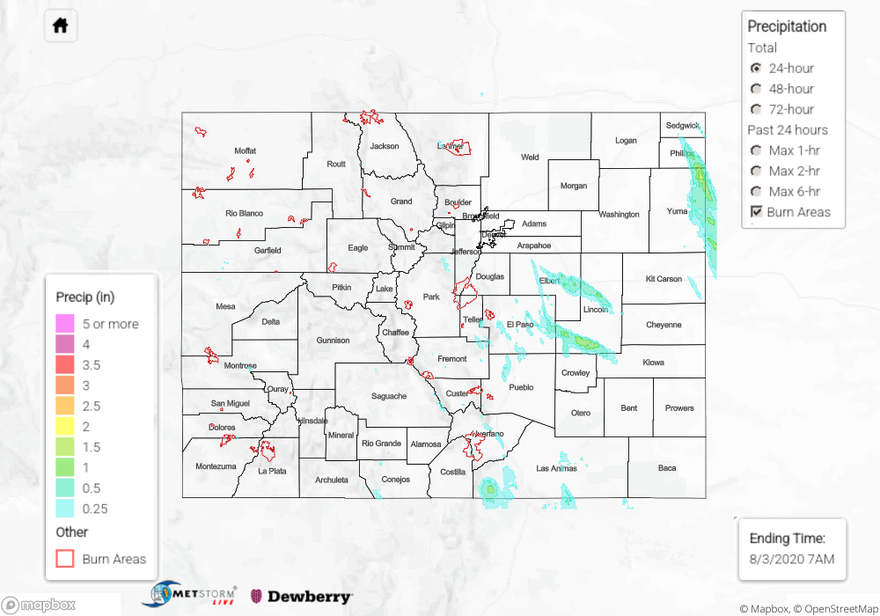
Some storms also fired over far eastern portions of the Northeast Plains overnight, which produced some heavy rain. These storms appeared to fire due an outlow boundary from the severe storms that moved over Lincoln County. The QPE map indicates between 1.5 and 2 inches of rain fell over a NW to SE track in Phillips and Yuma counties. The highest CoCoRaHS rain report in the area was 0.78 inches on the northeast side of Wray. A CoAgMET rain gauge reported 0.84 inches over southeast Phillips County this morning. Unfortunately, these gauges were not located within the swath of heaviest rainfall indicated by radar, so the higher QPE rain totals cannot be verified. Flooding has not been reported over the area as of this morning, but it did occur over the early morning hours, so flood reports may be submitted later today.
For rainfall estimates in your neighborhood over the last 24 hours, check out our State Precipitation Map below.
Click Here For Map Overview