Issue Date: 7/13/2015
Issue Time: 10:05 AM
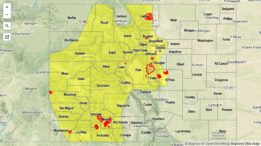
LOW FLOOD THREAST IS FORECAST FOR PORTIONS OF THE FOLLOWING REGIONS: SOUTHWEST SLOPE, SAN JUAN MOUNTAINS, GRAND VALLEY, CENTRAL MOUNTAINS, NORTHERN MOUNTAINS, NORTHWEST SLOPE, FRONT RANGE, AND URBAN CORRIDOR.
The upper-level high pressure ridge will remain in charge of the flow aloft across Colorado today, with southwest flow continuing the stream of subtropical moisture into the state. Absent from the upper-level environment is a trigger mechanism, so expect today to feature scattered showers and thunderstorms over the High Country and, with the mean flow directed from the west-southwest, a few isolated storms will move over adjacent low elevations of Eastern Colorado, as well. Precipitable water values are above average across western Colorado, so heavy rain and flash flooding will be possible underneath stronger thunderstorms, especially for areas of SW Colorado that received heavy rain yesterday.
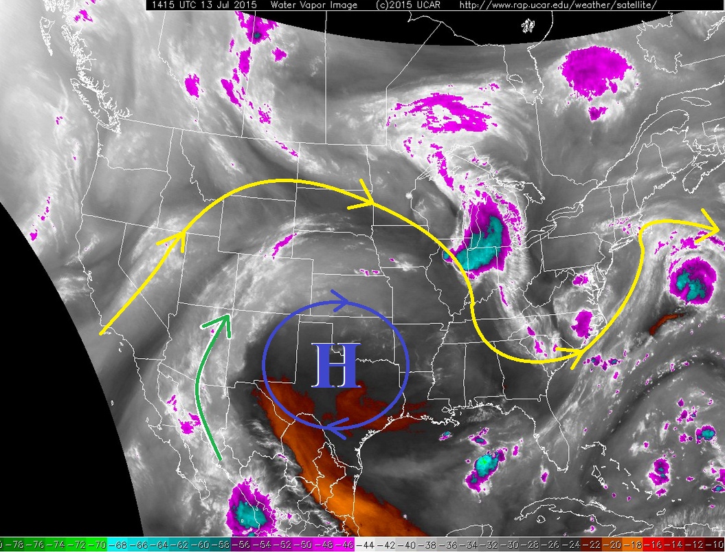
For the lower elevations of eastern Colorado, it will be a fairly typical July day with isolated thunderstorms moving off the mountains and over portions of the Palmer Ridge, Urban Corridor, Northeast Plains and Southeast Plains. Further east over the Southeast Plains, near the CO/KS border, a strong-to-severe thunderstorm or two will likely develop this afternoon and evening, with the main threats being lightning, hail, brief heavy rain, and strong winds.
Today’s Flood Threat Map
For more information on today’s flood threat, see the map below (hover over threat areas for more details). For Zone-Specific forecasts, jump below the map.

Zone-Specific Forecasts
Urban Corridor, Palmer Ridge, Southeast Plains, Northeast Plains, and Raton Ridge:
Isolated thunderstorms expected this afternoon and evening, with the best coverage near the mountains. A couple strong-to-severe storms will be possible across eastern portions of the Southeast Plains, mainly near the CO/KS border, where steep mid-level lapse rates and low-level moisture will be best. Rain rates will generally be 0.25-0.65 inches/hour, but stronger thunderstorms could produce rain at 0.6-1.2 inches/hour.
Primetime: 2 PM – 10 PM
Front Range, Northern Mountains, Northwest Slope, Grand Valley, Central Mountains, Southeast Mountains, San Luis Valley, Southwest Slope, and San Juan Mountains:
Scattered showers and thunderstorms are expected through today and into the nighttime hours as ample moisture continues to stream in from the southwest. Orographic forcing and daytime heating will be the main players in triggering the activity, so expect thunderstorms to initially develop over the higher ridges and move to the east-northeast with time. Rain rates will typically be 0.3-0.6 inches/hour, but stronger thunderstorms will potentially produce rainfall at 0.8-1.4 inches/hour. Some dry air below cloud base will help limit the flooding threat, as will storm motions. Areas that received heavy rainfall yesterday will be of main concern with regards to flash flooding issues today.
Timing: 11 AM – 10 PM, but a few showers and thunderstorms will persist into tomorrow morning as the moist, southwest flow continues.