Issue Date: Wednesday, July 22nd, 2020
Issue Time: 11:00AM MDT
Summary:
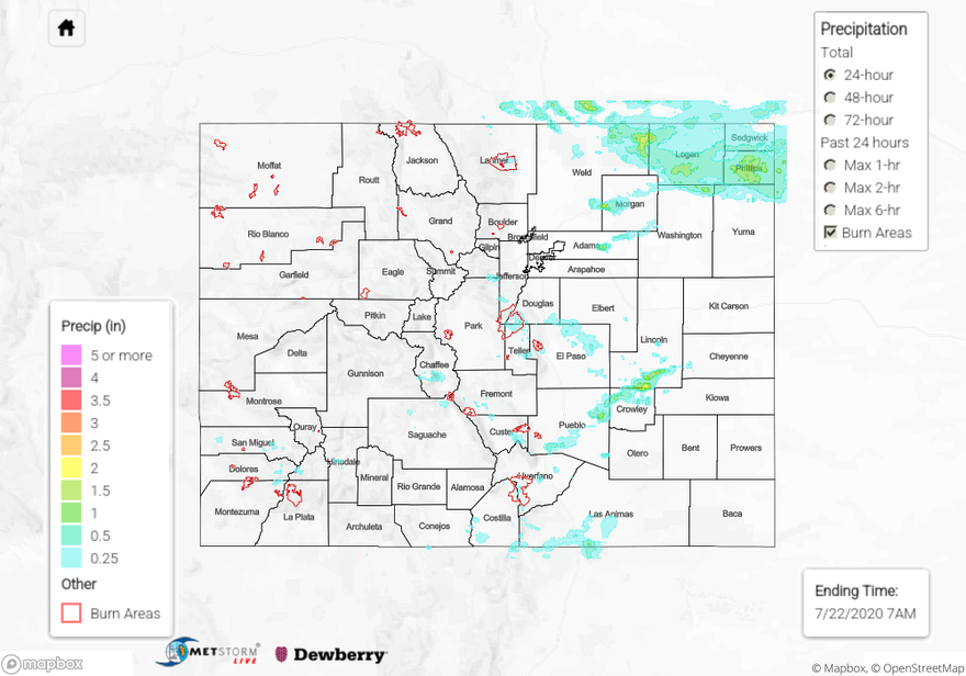
Some storms fired around noon over the Southeast Mountains and remained anchored over the higher terrain for a couple hours. This caused a Flash Flood Warning to be issued by NWS Pueblo over the Spring Creek burn area at 1:50PM MDT. The highest rain gauge accumulation of 0.36” was sent in by a CoCoRaHS observer near the area. The QPE map shows a very small area of rain totals over the 0.25” threshold, which generally agrees with gauge data. No flooding was reported near the Spring Creek burn scar, so these rain totals likely were not enough to cause issues.
As these storms moved off the higher terrain of the Southeast Mountains, one storm was able to generate 1.01” of rainfall (CoCoRaHS report) over Colorado City in southwestern Pueblo County. This prompted another Flash Flood Warning from NWS Pueblo at 5:47PM MDT. However, no flooding has been reported in the area as of this morning. The QPE map shows this isolated heavy rainfall over southern Pueblo County with up to 1 inch indicated, generally agreeing with the limited gauge observations nearby. The QPE map also shows that additional heavy rain fell to the northeast into Crowley and southern Lincoln counties. This was associated with a linear band of thunderstorms that intensified over this area. Unfortunately, rain gauge observations are not available to verify the up to 2 inches of rain indicated by QPE. The closest gauge over southern Lincoln County (CoCoRaHS) picked up 0.20” of rain.
A group of storms also fired over the southern Front Range between Denver and Colorado Springs. An ALERT gage over far southwestern Douglas County reported 0.94” of rain over an hour, with several other gages nearby picking up over 0.5 inch. This storm tracked southeast over Colorado Springs, dropping up to 0.51” of rain (CoCoRaHS) just west of town. The QPE map over this area appears to slightly underestimate rainfall, especially over southern Douglas County. No flooding was reported over this area, but hail up to 1” in diameter was observed.
The heaviest rain fell over the northeastern corner of the state, where several rain gauges reported over 1 inch of rain. The largest gauge total of 1.40” (CoCoRaHS) occurred over Logan County, with several reports of 1.35” just east in Phillips County. The QPE map shows a large swath from northeastern Weld County through Logan and Phillips counties with rain totals over 0.5 inches and up to 2 inches. The highest QPE totals up to 2 inches over northeast Weld County cannot be verified due to its remote location with no rain gauge observations. This significant rain fell over the evening (starting after 5PM MDT) and overnight (ending around 2AM MDT) as multiple clusters of thunderstorms drifted southeast off the Cheyenne Ridge. This beneficial rainfall brings the 3-day rain totals to 1-2.5 inches for much of this area of northeast Colorado, which will help keep the drought conditions from worsening.
For rainfall estimates in your area over the last 72 hours, check out our State Precipitation Map below.
Click Here For Map Overview