Issue Date: Tuesday, July 21st, 2020
Issue Time: 10:40AM MDT
Summary:
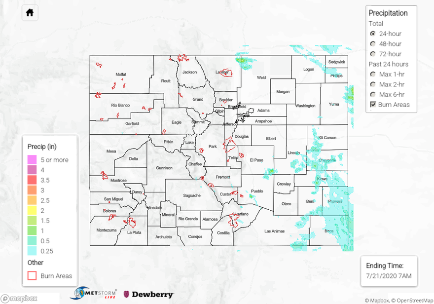
Severe thunderstorms developed over the eastern plains yesterday, which created strong winds, hail up to 1.5 inch in diameter, and even flash flooding. Two storms prompted Flood Warnings from the National Weather Service. One storm developed over southeast El Paso County around 3PM MDT, which quickly dropped up to 2 inches of rain and prompted NWS Pueblo to issue a Flash Flood Warning at 3:24PM MDT. Unfortunately, this area is quite remote and no rain gauges are available in the area. QPE estimates over this area are largely from radar estimates. No flooding was reported over this remote location as of this morning. The second storm developed over far northeast Larimer County into northwestern Weld County, between Fort Collins and Cheyenne, WY. Storms re-generated and trained over this area between 2PM and 6PM MDT according to radar. This caused NWS Boulder to issue a Flash Flood Warning at 04:18 PM MDT. A flash flood report was sent in near the town of Carr at 4:47PM MDT, near I-25. A surprising 2.63 inches of 24-hour rainfall was reported near Carr by a CoCoRaHS observer. QPE only shows up to 2 inches of rain over this area, suggesting under-estimation of rain totals. Some other Weather Underground and CoCoRaHS stations reported up to 0.71 inches of rainfall near the area, indicating just how isolated these heavy rain totals were. Outside these two isolated storms, a large area of the Northeast and Southeast Plains picked up between 0.25 and 0.75 inches of beneficial rainfall according to QPE and rain gauge reports.
West of the Continental Divide, storms were weak and stayed over the southern half of the state. The Northern Mountains and Northwest Slope saw mainly sunny skies yesterday. The heaviest rain fell over the Southwest Slope and southern San Juan Mountains, but remained below 0.25 inches. The highest rain report came from Montezuma along the Southwest Slope of 0.24 inches by a CoCoRaHS observer.
For rainfall estimates in your area, check out our State Precipitation Map below.
Click Here For Map Overview