Issue Date: Sunday, July 19th, 2020
Issue Time: 9:35AM MDT
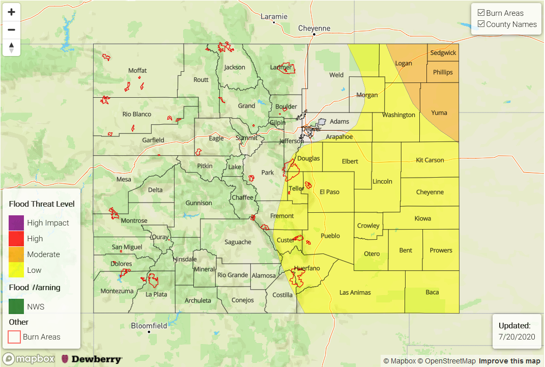
— A MODERATE flood threat has also been issued for the Northeast Plains
— A LOW flood threat has also been issued for Palmer Ridge, Raton Ridge, Southeast Plains, southern Front Range, southern Urban Corridor and the Spring Creek burn area
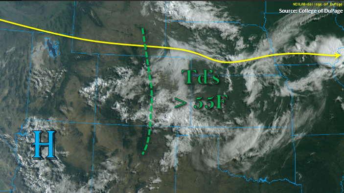
It is quite moist over the eastern half of Colorado behind the frontal passage that occurred last night. This can be seen by the stratus deck in the visible satellite imagery below. For the most part, dew point observations are greater than 55F east of the green dashed line (low 50Fs for the elevated ridges), and PW was measured at 0.89 inches in Denver this morning. While some of this moisture will mix out to the east under weak westerly/northwesterly flow aloft, plenty will remain for widespread, post-frontal rain this afternoon. As storms move off the eastern mountains and into the higher moisture, slow steering winds will increase the threat for heavy rainfall. Furthermore, with the cloud deck already starting to break up, higher instability will cause the coverage of thunderstorms to increase as they track east.
A few severe thunderstorms can be expected this afternoon, especially over the Northeast Plains. Therefore, a Moderate flood threat has been issued for maximum instability, moisture, and lift over the region, and a Low flood threat has been issued for the eastern plains and elevated ridges. The Low flood threat was extended back to the west to include the Spring Creek burn area.
Back to the west, moisture will continue to decrease as indicated by the PW value at Grand Junction dropping to 0.73 inches. Cloud cover over the area (seen below) indicates that there is still plenty of residual moisture in the region for another round of afternoon and evening convection over the mountains. However, lighter rain rates are anticipated this afternoon and the main threat from thunderstorms will be strong outflow winds. Storms will again favor the central and southern San Juan Mountains and better coverage over the Central Mountains should be near and along the Continental Divide.
Today’s Flood Threat Map
For more information on today’s flood threat, see the map below. If there is a threat, hover over the threat areas for more details, and click on burn areas to learn more about them. For Zone-Specific forecasts, scroll below the threat map.
Zone-Specific Forecasts:
Southeast Mountains, Front Range, Raton Ridge, Southeast Plains, Palmer Ridge, Northeast Plains, & Urban Corridor:
Widespread showers and thunderstorms are expected to pop over the eastern mountains by around noon and push in to the Urban Corridors shortly after. Storm coverage will be best south of Boulder County and increase into the Southeast Mountains. There’s high confidence in widespread storms over the Spring Creek burn area today, and max 1-hour rain rates up to 0.50 inches are possible. So, if a storm forms over the burn area, flash flooding, mud flows, and debris slides will be possible. The always active Palmer Ridge and eastern Raton Ridge could see rain totals just over 1 inch/hour, which could cause urban flooding issues such as road flooding and sharp rises in local streams. A Low flood threat has been issued for these two forecast regions.
As storms move east, they are expected to expand in coverage and intensity. Max 1-hour rain rates up to 1.75 inch/hour will be possible over the eastern plains, so a Low flood threat has been issued. Best instability, lift, and moisture should reside over the Northeast Plains, and severe thunderstorms that form in the area will be capable of producing large hail (2-inch diameter) and damaging winds, and very heavy rainfall. Max 1-hour rain rates up to 1.9 inches and morning totals just over 2 inches will be possible. Storms should exit out of the state just before midnight.
Primetime: 11:30AM to 11PM
Northwest Slope, San Juan Mountains, Central Mountains, Grand Valley, Southwest Slope, Northern Mountains, & San Luis Valley:
Residual moisture will allow for another round of afternoon convection to form over the mountains and ridges. Coverage will be more spotty north of the San Juans, and the best chance for storms over the Central Mountains will be along and near the Continental Divide. Max 1-hour rain rates up to 0.25 inch (north) and 0.40 inches (south) will be possible. The main threat from storms today will be strong outflow winds in the 40 to 50 mph range and lightning. The interior San Luis Valley is expected to stay dry today, but had some nice rainfall accumulation yesterday. High temperatures should be in the 90Fs across the lower elevations with high-70Fs for the mountains.
Primetime: Noon to 9PM