Issue Date: Saturday, July 18th, 2020
Issue Time: 9:30AM MDT
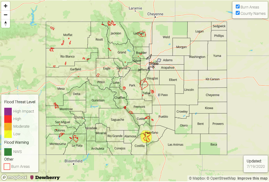
— A LOW flood threat has also been issued for the Spring Creek burn area
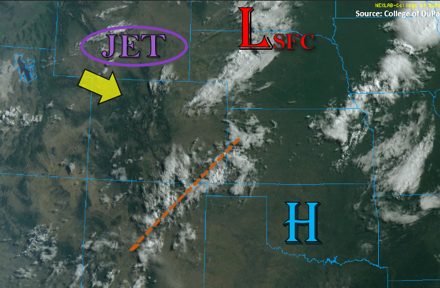
The 500mb High has start its migration east, which has shifted the axis of moisture and mid-level energy with it (orange dashed line). PW values over Grand Junction were still measured at 0.80 inches with slightly higher values south. As the High shifts and flow becomes more northwesterly with the passing trough to our north, there should be a downtick in moisture from northwest to southeast across western Colorado. There will still be plenty of moisture across the southern border, so widespread storms are still anticipated to fire over the southern high terrains this afternoon and favor the San Juan Mountains for development. With PW values decreasing over the Central and Northern Mountains, rain rates and coverage of storms should decrease as well.
There has been a good amount of rain that has fallen over the southern San Juan Mountains the last three days, but gages in the area are not indicating large increases in runoff or high flows. So, with better mid-level energy to the east, decreasing rain rates, and small rainfall cores, no flood threat will be issued. As for the 416 burn area, rain rates in the area are forecast to remain under our flood threat threshold of 0.75 inches/hour and coverage of storms near the area are expected to decrease. So, no flood threat will be issued for the area today. Of course, if a storm forms directly over a burn area, there is always a chance of flash flooding, so beware and follow NWS Grand Junction for the latest on warnings.
Over eastern Colorado, a dry surface layer will cause storms to produce more wind than rain as they move off the high terrains. A little better moisture will be south, associated with the shifting plume, so best coverage of storms is expected over the Southern Front Range, Southeast Mountains, and western Raton Ridge. With the plume and associated mid-level energy moving east, max 1-hour rain rates around 0.50 inches will be possible near the Spring Creek burn area. Thus, a Low flood threat has been issued. A cold front will cross the northern border by early this evening, which may spark a few thunderstorms over the far northeast corner of the state, but flooding is not anticipated from the storms.
Today’s Flood Threat Map
For more information on today’s flood threat, see the map below. If there is a threat, hover over the threat areas for more details, and click on burn areas to learn more about them. For Zone-Specific forecasts, scroll below the threat map.
Zone-Specific Forecasts:
San Juan Mountains, Central Mountains, Grand Valley, Southwest Slope, Northern Mountains, Southeast Mountains, Front Range, Raton Ridge, & San Luis Valley:
Widespread afternoon showers and thunderstorms are anticipated again this afternoon for the San Juan Mountains, southern Front Range and Southeast Mountains, and the highest totals should be near the southern border. With rain rates up to 0.5 inches possible (east and south), a Low flood threat has been issued for the Spring Creek burn area. Storms could sit with the weak flow aloft, so slightly higher totals could cause flash flooding of local stream, mud flows, or debris slides. Back over the San Juan Mountains, isolated, max 1-hour rain rates up to 0.60 inches will be possible. Further north over the Central Mountains and higher terrains, max 1-hour rain rates under stronger storms will be 0.30 inches, and some gusty outflow winds will be possible.
Primetime: 11:30AM to 11PM
Northwest Slope, Southeast Plains, Palmer Ridge, Northeast Plains, & Urban Corridor:
These regions should stay mostly dry today with high temperatures similar to yesterday. As storms move off the mountains/Cheyenne Ridge, expect more gusty wind than rainfall with totals up to 0.15 inches possible. A cold front will move through the eastern plains tonight, and there is a chance that it may spark an isolated thunderstorm or two that could track over the northeast corner of the state. Max 1-hour rain rates up to 1 inch with be possible along with small hail and gusty winds if storms track into the area. There may also be a chance for some light, overnight rainfall over the Southeast Plains as mid-level energy mixes with the increased surface moisture from the frontal passage. Flooding is not forecast.
Primetime: 2PM to Midnight