Issue Date: Friday, July 17th, 2020
Issue Time: 9:15AM MDT
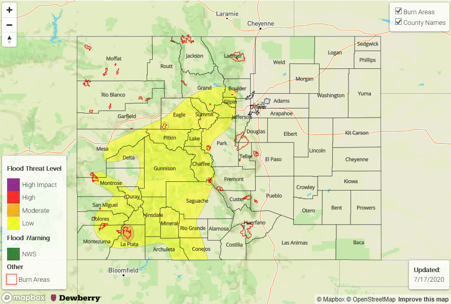
— A MODERATE flood threat has been issued for the 416 burn area
— A LOW flood threat has also been issued for the San Juan Mountains, Central Mountains, and portions of the Front Range, Northern Mountains, Southwest Slope, and Grand Valley. This includes the Decker and Lake Christine burn areas.
It’s going to be a rinse and repeat pattern for today with only a couple small changes to the details. The 500mb high is still over Texas, which is continuing the subtropical moisture stream from the south. This, along with some mid-level energy moving through the flow, will return widespread showers and thunderstorms to the mountains this afternoon and evening. One change to the forecast will be that the High starts to migrate to the east and a weak shortwave to our northwest will move overhead. This will change flow aloft to more westerly over the state, which will cause some drying over the adjacent eastern plains and northern border. So as storms move off the eastern mountains, more gusty winds are expected and rainfall totals should decrease when compared to yesterday.
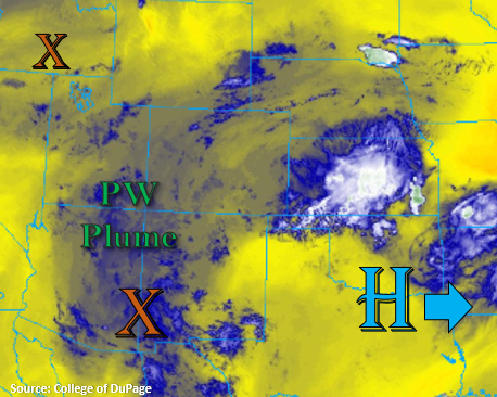
PW in the Grand Junction sounding this morning was measured at 0.88 inches with slightly higher values over the southwest corner. This PW value is in the ~80th percentile for this time of year, which is plenty high for meaningful rainfall accumulation. With clearing already starting to happen over the San Juan Mountains, expecting higher CAPE values to build again this afternoon, which will lead to widespread thunderstorm coverage. Storm motion will also slow down a bit when compared to yesterday, and rain efficiency should increase with the boundary layer a little moister. Thus, a Low flood threat has been issued again for the San Juan Mountains and will include the Central Mountains along with high terrains near the Continental Divide.
The 416 burn area yesterday received between 0.10 and 0.25 inches. With thunderstorms likely again this afternoon, and increasing rain rates expected, a Moderate flood threat has been issued for the burn area. The Low flood threat includes the Lake Christine and Decker burn areas. While thunderstorm coverage will decrease further north, rain rates will likely be high enough to meet flood threat criteria for those burn areas. If a storm tracks overhead this afternoon flash flooding of local streams, mud flows, and debris slides may be possible.
Today’s Flood Threat Map
For more information on today’s flood threat, see the map below. If there is a threat, hover over the threat areas for more details, and click on burn areas to learn more about them. For Zone-Specific forecasts, scroll below the threat map.
Zone-Specific Forecasts:
San Juan Mountains, Central Mountains, Grand Valley, Southwest Slope, Northern Mountains, Southeast Mountains, Front Range, Northwest Slope, & San Luis Valley:
Widespread afternoon showers and thunderstorms are anticipated again this afternoon. Best coverage and highest rain rates will be over the San Juan Mountains. A Low flood threat has been issued with a Moderate threat for the 416 burn area. Max 1-hour rain rates up to 0.75 inches will be possible with totals up to 1.1 inches by morning. Some rainfall is also forecast for the San Luis Valley with totals along the edges and southern end of the valley up to 0.20 inches. Similar to yesterday, expect storms to linger overnight with the extra mid-level energy in the area.
Further north, coverage will decrease, but max 1-hour rain rates up to 0.5 inches will still be possible. This could cause flooding issues if storms track over the Decker or Lake Christine burn area, so they have been included in the Low flood threat. Higher rainfall amounts north will occur along and near the Continental Divide. Over the Southeast Mountains, Northern Mountains, and northern Front Range max 1-hour rain rates up to 0.30 inches will be possible.
Primetime: 12:30PM to 2AM
Southeast Plains, Palmer Ridge, Raton Ridge, Northeast Plains, & Urban Corridor:
It’s going to be warm today with temperatures increasing a few degrees. There is a decreased chance in rainfall compared to yesterday. A few storms may survive as they move off the eastern mountains over the Palmer and Raton Ridge. However, max 1-hour rain rates should decrease to 0.50 inches, so flooding is not expected. Additional storms may fire along the southern border along a west to east boundary, but the main threat from those storms today will be gusty outflow winds with a drier surface layer. Overall, it should be a pleasant day.
Primetime: 1PM to Midnight