Issue Date: Tuesday, July 14th, 2020
Issue Time: 10:55AM MDT
Summary:
Thunderstorm outflow from numerous storms created wind gusts over 50 mph for much of northern Colorado yesterday, but not much in the way of rainfall. The true color satellite image below shows the wide coverage of storms by 6pm MDT yesterday. The more vigorous storms are evident in the true color satellite imagery over northeast Colorado. The border counties of the Northeast Plains were able to pick up the heavier rain totals due to the increased surface moisture, where dew points reached into the upper 50Fs. Back west in the lower surface moisture, more wind than rainfall was reported. The highest wind gusts were reported in Weld County where up to 77 mph winds caused power pole and building damage, which was associated with a severe thunderstorm that moved through the area between 4-5PM MDT. A couple strong wind gusts up to 60 mph were also reported in Montezuma and Las Animas counties in southern Colorado. These thunderstorm outflow winds were common due to dry sub-cloud air over these regions. Although NWS Grand Junction did not do soundings yesterday, it is inferred this area had the same inverted-V atmospheric sounding seen at Denver.

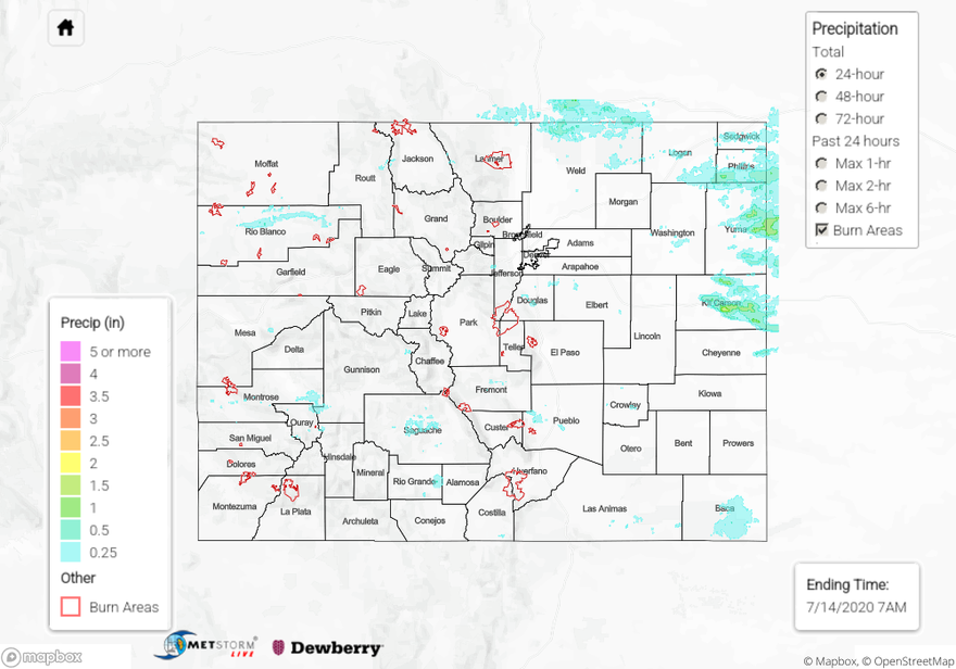
While flooding was not reported yesterday (as of this morning), much of the state picked up measurable rainfall from the west to east moving scattered thunderstorms. The heaviest rain totals occurred over the Northeast Plains, where up to 1.23 inches of rain accumulation was reported by a NWS rain gage. Just under 2 inches of rain was estimated by Metstorm over Kit Carson County. CoCoRaHS in the area, just north of the storm core, reported just under 1 inch of rainfall.
Although moisture was limited farther west along the Urban Corridor, up to 0.32 inches of rain fell at a rain gage just west of Fort Collins, and 0.38 inches of rain was reported by a CoCoRaHS observer in the foothills west of Denver. QPE and CoCoRaHS reports indicate that mountain regions with storms that tracked overhead picked up to 0.30 inches of rain. Even the San Luis Valley got in on the action! Up to 0.5 inches of rain fell along the western edge of the San Luis Valley.
Unfortunately, a new fire broke out near the town of Evergreen. It is named the Elephant Butte Fire, has burned 50 acres as of this morning, and prompted evacuations of more than 1000 homes. The smoke was visible from the Denver area yesterday. Luckily, no injuries or damaged structures have been reported yet, and cooler temperatures today and some rainfall last night will hopefully allow emergency workers to get it under control today.
For rainfall estimates in your area, check out our State Precipitation Map below.
Click Here For Map Overview