Issue Date: Sunday, July 5th, 2020
Issue Time: 10:10AM MDT
Summary:
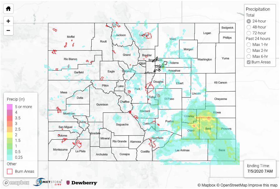
The moisture plume had settled in over the state yesterday, and paired with some mid-level energy and slow steering flow, this set the stage for another day where storms could produce heavy rainfall. Action kicked off a little earlier over the mountains, which limited the amount of instability that could form. Therefore, rain rates were on the lower end. There were still some impressive totals for the pulsing storms, and SNOTEL sites recorded between 0.30 and 0.40 inches. A RAWS station near Vail recorded 0.50 inches, and another gage near Ruedi Reservoir recorded 0.56 inches. A Flash Flood Warning was issued for the Spring Creek burn area at 3:45PM and again at 5:30PM. QPE from the storms was estimated between 0.50 and 0.75 inches over the north portion of the burn area. The La Veta Pass NWS gage was located just to the south of the rainfall, so it wasn’t helpful in determining how much rain actually fell. RAWS gages just north of the burn area measured between 0.43 and 0.49 inches of rain. Flooding was not reported.
As storms moved off the mountains, they encountered better moisture and instability, which let them grow in coverage and strength. CoCoRaHS stations in Rocky Ford recorded just under 2 inches for the 24-hour period. MetStorm estimated 1-hour rain rates at 2 inches between Rocky Ford and La Junta. The La Junta NWS gage recorded 1.08 inches for the 24-hour period, so that core of 3.5 inches in the MetStorm QPE is likely high. My best guess is around 2 to 2.25 inches for the 24-hour period. There was flooding reported in La Junta with 2.5 to 3 feet of water flooding Highway 50 closing the road at the railroad overpass. The totals along the Kiowa and Bent County border is also likely high as CoCoRaHS in the area reported between 1.15 and 1.29 inches. Nonetheless, this was beneficial rainfall for an area experiencing a severe and worsening drought. Over the Metro area, there were a few ALERT gages just east of town (Aurora) that recorded between 1.18 and 1.65 inches of rain. There was a report of 3.13 inches from a spotter at Buckley Air Force Base, which I believe is high. The ASOS gage at Buckley recorded 1.46 inches, which is in line with 1.65 inches at the ALERT Sand Creek and Colfax gage. Flooding was not reported in this area despite a Flash Flood Warning being issued.
For precipitation estimates in your neighborhood over the last 24 to 72-hours, scroll down to the State Precipitation Map below. Note that Yuma and Kit Carson County 48 and 72-hour totals are likely inflated as I’ve shown QPE was likely overestimated the last couple of days compared to observations in the area.
Click Here For Map Overview