Issue Date: Friday, July 3rd, 2020
Issue Time: 9:45AM MDT
— A LOW flood threat has been issued for the Northeast Plains, Palmer Ridge, portions of the Southeast Plains, and the southern Urban Corridor
— A LOW flood threat has been issued for the Spring Creek burn area
Growing high pressure over the state has successfully pulled the aforementioned subtropical moisture northward on its west side. This can be seen in the visible satellite imagery below (“plume”), and PW has increased to 0.55 inches over Grand Junction. Most of this moisture looks to be in the mid-levels, so storms that form over the San Juan and Central Mountains with the combination of the diurnal flow and weak mid-level energy today should produce more wind than wetting rainfall. However, scattered storms will return to the forecast favoring south and southwest facing slopes for accumulations.
Over eastern Colorado, PW will be on the rise (measured at 0.67 inches in the 12Z sounding) as southeasterly surface winds increase in intensity throughout the day with a developing lee trough. Some mixing out of the surface moisture from west to east is still expected, but it is not forecast to be quite as severe as yesterday. Additionally, moisture looks healthier throughout the different layers of the atmosphere, so more wetting rainfall is anticipated.
The best moisture will sit east of ~104W (Highway 71), so expecting storms to increase in intensity and coverage around this marker. Storms further west will likely produce some strong outflow winds this afternoon. Furthermore, the 500mb high will begin to build over New Mexico/Arizona, which will decrease the counter clockwise steering flows and allow storms to drop more rainfall over an area. Thus, a Low flood threat has been issued for a majority of eastern Colorado. Some severe thunderstorms should also be expected over the eastern plains, and these will be capable of producing large hail along with damaging outflow winds. The Low threat has also been extended back to the Palmer Ridge as a quick 0.50 inches in 30-minutes could cause some urban flooding issues. Lastly, multiple rounds of rainfall may cause some flooding issues over the Spring Creek burn area today. Totals by morning around 0.50 inches will be possible, so a Low flood threat has been issued for precaution and increased outdoor recreation around the area.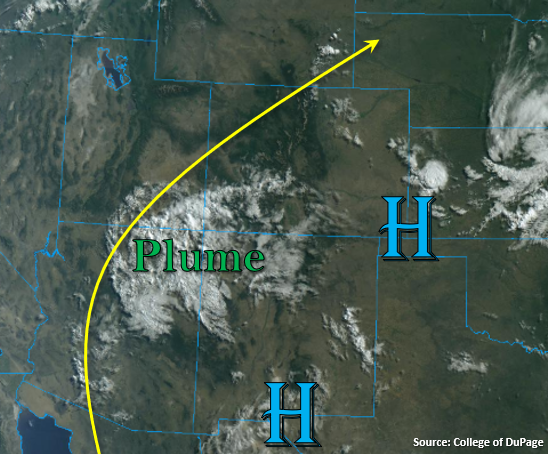
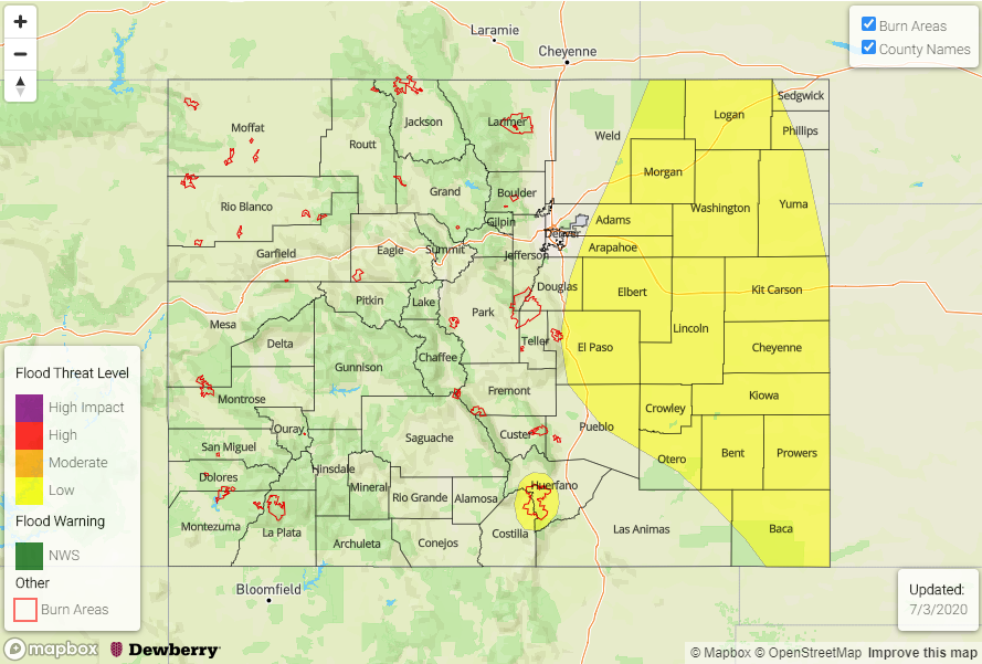
Today’s Flood Threat Map
For more information on today’s flood threat, see the map below. If there is a threat, hover over the threat areas for more details, and click on burn areas to learn more about them. For Zone-Specific forecasts, scroll below the threat map.
Zone-Specific Forecasts:
Southeast Plains, Northeast Plains, Palmer Ridge, Urban Corridor, Southeast Mountains, Raton Ridge, & Front Range:
Afternoon and evening storms will return to the forecast for all of these zones. Best coverage of storms over the mountains will be over the southern Front Range and Southeast Mountains. Max 1-hour rain rates up to 0.45 inches will be possible with most storms producing around 0.30 inches. Most surface moisture will mix out over the immediate adjacent plains, so expect some gusty outflow winds this afternoon. Moisture hangs on a little better over the Palmer Ridge, and with increased convergence, a quick 0.50 inches in 30-min could cause some urban flooding issue. So, a Low flood threat has been issued.
Severe storms will be likely over the eastern plains again, and outflow boundaries from yesterday/today will likely produce widespread coverage of heavy rainfall producing thunderstorms. With slowing steering winds, a Low flood threat has been issued. Lastly, multiple rounds of rain over the Southeast Mountains are anticipated. This could cause issues over the Spring Creek burn area if multiple storms track overhead, so a Low flood threat has been issued. Be sure to tune into your local NWS office this afternoon for the latest on Flash Flood Warnings issued. Storms will linger a little later tonight with the increase in moisture and mid-level energy over the state.
Primetime: 12:30PM to 2AM
Central Mountains, Northern Mountains, San Juan Mountains, Northwest Slope, San Luis Valley, Grand Valley, & Southwest Slope:
Best chance for some wetting rainfall will be over the San Juan Mountains with windier (gusts up to 45 mph), lighter rain possible over the Central Mountains. This is due to another day with large dew point depressions. Rainfall today will likely help moisten the boundary layer, which will allow rainfall to become more efficient tomorrow. Max 1-hour rain rates up to 0.25 inches will be possible over the San Juan Mountains with totals under 0.15 inches further north. Flooding is not expected today.
Primetime: 12:30PM to 1AM