Issue Date: Thursday, July 2nd, 2020
Issue Time: 9:10AM MDT
— Flooding is NOT expected today
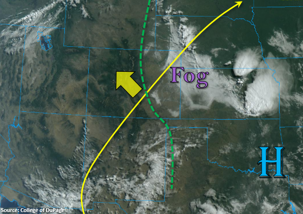
The image below shows very different air masses present east and west of the Continental Divide. Clear conditions over western Colorado indicate that a very dry air mass is still in place, which is confirmed by the Grand Junction sounding this morning that measured PW at 0.32 inches. This means outside of some scattered clouds over the mountains this afternoon, it will be too dry for any rainfall. So, expect increasing high temperatures as the ridge builds to the northwest without much relief from the heat.
Over eastern Colorado, southwest surface flow has returned low-level moisture to the area, which can be seen by the cloud cover and fog over the eastern plains. Currently, high dew points (> 50F) are to the east of the dashed, green line below. Weak southwesterly flow aloft this afternoon and a developing lee trough will help to mix out this superficial surface moisture from west to east. So, low-level moisture over the Front Range looks to be limited, but some weak, upslope storms will still be possible over the southern Southeast Mountains. The main hazard from these storms will be gusty outflow winds with only light rainfall forecast.
Over the eastern plains, a moisture boundary sets up, so some severe thunderstorms should develop along that dry line this afternoon. The best instability will quickly erode into Kansas and Nebraska, but the severe storms that initially develop will be capable of producing large hail with strong, damaging outflow winds being the main threat shortly thereafter. Due to the better moisture continuing to mix out to the east through the late afternoon/early evening (especially over the Southeast Plains), local, heavy rainfall will be limited in coverage. Therefore, there is no flood threat issued, but storms that form over the Northeast Plains border counties will still be capable of dropping up to 1.40 inches of rain in their cores – if the moisture can hang on.
Today’s Flood Threat Map
For more information on today’s flood threat, see the map below. If there is a threat, hover over the threat areas for more details, and click on burn areas to learn more about them. For Zone-Specific forecasts, scroll below the threat map.

Zone-Specific Forecasts:
Southeast Plains, Northeast Plains, & Palmer Ridge:
High temperatures will continue to rise a few degrees this afternoon. It will also feel relatively muggy with the high dew points in the area, which will increase the heat index. Storms are expected to develop along a moisture boundary this afternoon and move to the northeast. Some severe thunderstorms are possible. Initially, storms will be capable of producing very large hail with the wind threat increasing as moisture continues to mix out to the east. Local, heavy rainfall up to 1.40 inches will be possible over the Northeast Plains (border counties) if the surface moisture can hang on. The coverage of the heavy rainfall will be limited, so there is no flood threat issued. Further south, max 1-hour rain rates around 0.75 inches will be possible. Storms should exit the state by 7PM or so. Lingering, light showers may be possible over the Southeast Plains tonight.
Primetime: 1PM to 7PM
San Juan Mountains, Front Range, San Luis Valley, Urban Corridor, Southeast Mountains, & Raton Ridge:
Since the moisture will be mixing out to the east today, only some weak storms are forecast for these mountains’ zones with the diurnal flow pattern. Moisture will be a little better further south and with some disturbances moving through the flow, some light rainfall will be possible. Max 1-hour rain rates up to 0.20 inches will be possible over the southern Southeast Mountains, but the main threat from storms will be gusty outflow winds. Totals will decrease over the Front Range and San Juan Mountains with max totals under 0.10 inches. Virga will cause some windy conditions as storms create outflow boundaries.
Primetime: 1PM to 8:30PM
Central Mountains, Northern Mountains, Northwest Slope, Grand Valley, & Southwest Slope:
A Red Flag Warning remains in place for portions of the Northwest Slope today. Southwest winds are expected in the 15 to 20 mph range with gusts up to 30 mph. With relative humidity in the teens, elevated fire danger is expected. High temperatures will also increase a couple of degrees this afternoon when compared to yesterday. With little to no cloud cover expected, be sure to stay hydrated with any outdoor activities.