Issue Date: Friday, June 19th, 2020
Issue Time: 10:25AM MDT
Summary:
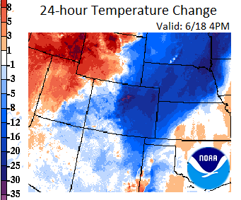
After the passage of a cold front, temperatures dropped off quite a bit over the state. Below is from the Weather Prediction Center (WPC) and shows the 24-hour change from 4PM on Wednesday to 4PM on Thursday (yesterday). The effects of the front were much stronger over eastern Colorado, and over the Front Range, a couple of the stations showed a 30F swing! The interesting part of the map is over the northwest corner where temperatures actually increased. This was likely to the front already passing through prior to the rest of the state on Wednesday and the timeframe used to create this image.
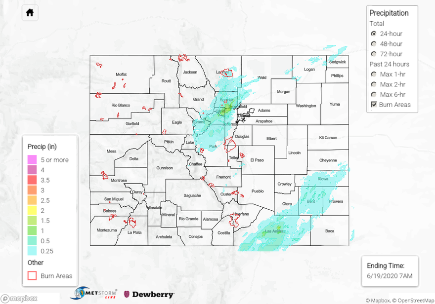
Moisture also returned behind the front, so storms returned to the mountains. Over western Colorado, a lot of the moisture was scoured out, so totals over the Central and Northern Mountains were under 0.10 inches. The heaviest rainfall was over the Front Range, which started early in the morning. Rainfall was gradual enough that flooding issues were avoided. Up to 1.5 inches of rain were estimated by radar in Jefferson County, and an ALERT gage near Coal Creek recorded 1.26 inches. The Jackwhacker Gulch (best name ever) SNOTEL gage recorded 0.80 inches near Montezuma, CO.
Additional rainfall fell over the Southeast Plains in the evening and overnight. A severe thunderstorm near Hoehne, CO produced 1-inch hail around 10PM and a gust of 67 mph. Totals were generally in the 0.50 to 0.75 inch range over the area. The Perry Stokes airport ASOS showed about 2 inches of rainfall in a 1-hour period, which means there was a lot of moisture in the area for limited instability (after the sunset). Heavy rainfall also developed overnight along the Raton Ridge, and 3 inches of rain was reported near Trinidad along with street flooding around 1:30AM. Other places in the storms’ paths received around 2.50 inches for the 24-hour period. So my best guess for overnight 1-hour rainfall rates is ~1.75 inches. Wowza!
For precipitation estimates in your neighborhood over the last 24-hours, scroll down to the State Precipitation Map below.
Click Here For Map Overview