Issue Date: Friday, June 19th, 2020
Issue Time: 9:45AM MDT
— A MODERATE flood threat has been issued for the Southeast Plains and portions of the Northeast Plains, Urban Corridor, Palmer Ridge
— A LOW flood threat has been issued for the northern Southeast Mountains and eastern Raton Ridge. This includes the Decker burn area.
Another cool start to the day with most of the state waking up to cloudy conditions. As of 7:30AM, snow was being reported at La Veta Pass! There were also reports of rain and fog over the mountains, which is due to mid-level lift out in front of the base of the trough and an upper level jet. Behind this area of lift, drier conditions are forecast, which can be seen by the cloud free conditions over western Colorado. Rainfall is not forecast behind the vorticity maximum (orange “X”). The visible imagery also shows how moist it is over eastern Colorado with a large cloud deck in place. PW over Denver was measured at 0.60 inches, but higher values are present over Southeast Colorado.
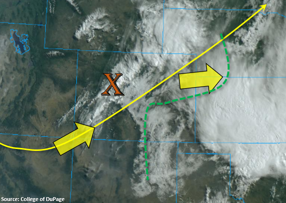
Today, the area of lift/storms (orange “X”) will move eastward and intensify as they move into the moisture rich environment just off the foothills (southwesterly surface flow). It looks like a little moisture may scour out westward over Northeast Colorado, but heavy rainfall is still anticipated over the eastern portion of the metro area due to lower storm motions (10 to 15 mph to the west) and trailing thunderstorms. A few breaks in the cloud cover east will also help intensify the storms, so a Moderate flood threat has been issued for the eastern metro area/Palmer Ridge.
Storms will likely become severe as they move into regions with more widespread, cloud-free conditions due to better instability being able to build. This is most likely to happen over the Southeast Plains where the cloud deck isn’t quite as thick, and there are already breaks in the cloud over this area (see image above). Severe thunderstorm threats include large hail and strong winds. Dew points over southeast Colorado will be just over 50F, so heavy rainfall is also anticipated with the severe thunderstorms that form. Most of the thunderstorms that form today will roll into Nebraska and Kansas by 9PM, but a few lingering overnight storms are possible over the far Southeast Plains border counties. This is why the Moderate flood threat has been extended south.
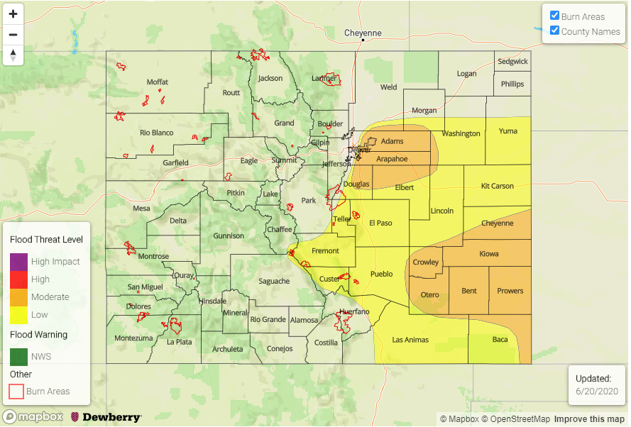
Today’s Flood Threat Map
For more information on today’s flood threat, see the map below. If there is a threat, hover over the threat areas for more details, and click on burn areas to learn more about them. For Zone-Specific forecasts, scroll below the threat map.
Zone-Specific Forecasts:
Southeast Mountains, Southeast Plains, & Raton Ridge:
Over the Southeast Mountains, storm coverage won’t be quite as widespread as the Front Range. Max 1-hour rain rates up to 0.50 inches will be possible near the Decker burn area, so the Low flood threat has been extended back to capture this. A couple storms will likely form on the Raton Ridge as well. Rain rates will increase as storms move off the mountains and reach the I-25 corridor with max 1-hour rain rates up to 1.1 inches possible, so a Low flood threat has been issued. A severe storm or two is possible in areas where cloud’s break, which will likely be further east over the Southeast Plains. Paired with high moisture, max 1-hour rain rates up to 1.75 inches will be possible, so a Moderate flood threat has been issued. Additional overnight storms are possible over Baca and Prowers Counties, and in a moisture rich environment, 24-hour totals could reach values greater than 2 inches. Thus, the Moderate threat has been extended south.
Primetime: 12:30PM to 3AM
Front Range, Northeast Plains, Urban Corridor, & Palmer Ridge:
Storms are not expected to be as severe over these regions due to higher cloud cover and cooler temperatures (lower instability). Max 1-hour rain rates up to 0.75 inches will be possible over the southern foothills and western metro area. A quick 0.50 inches in 30 min could cause flooding issues over the impervious surfaces, so a Low flood threat has been issued. Up north, max 1-hour rain rates drop off a little more due to slightly lower moisture in the area, but a good wetting rain is still coming your way. Dew points looks to increase just east of the I-25 corridor in the southern Urban Corridor, so trailing storms and increased convergence on the higher elevation of the Palmer Ridge could produce 1 to 2-hour totals up to 1.25 inches in the moisture rich environment. Thus, the Moderate flood threat for the area. Storms should exit the Moderate flood threat region by late afternoon. Out east, totals will generally be between 0.75 and 1.25 inches.
Primetime: 12:30PM to 9PM
Central Mountains, San Juan Mountains, Northern Mountains, Northwest Slope, Grand Valley, San Luis Valley, & Southwest Slope:
After this morning’s mountain rainfall, these regions will move into the dry slot, and that will be the end of the rainfall for this system. Highs over the valleys will reach into the 80Fs, so it should be a pleasant day. An Air Quality Alert remains in place over the southwest corner, and the approaching trough will likely increase surface winds over this area. Thus, a Red Flag Warning is issued for westerly winds in the 10 to 20 mph range (gusts to 30 mph) and relative humidity dropping into the teens and single digits.