Issue Date: Saturday, June 13th, 2020
Issue Time: 9:25AM MDT
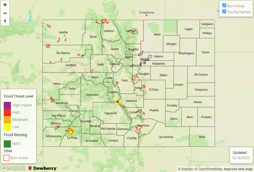
— A LOW flood threat has been issued for the 416 and Decker burn areas
We’ll start this forecast by taking at a look at the mid-level atmospheric set up below (500 mb). Today, the Low that has been in the Gulf of Alaska moves inland and merges with the shortwave that was off the coast of California. As this joining happens over the Pacific Northwest, vorticity and faster wind speeds (purple oval) will move into western and central Colorado, which will help provide upper dynamic support (lift) for storms this afternoon and evening favoring the high terrains. Flow aloft, which helps set the steering winds for storms, will be increasingly southwesterly over western/central Colorado and gain a slight westerly component over the foothills and adjacent plains in eastern Colorado. Moisture has also been making its way into the state, and PW values this morning we measured at 0.57 and 0.63 inches in Grand Junction and Denver, respectively. This moisture is expected to increase throughout the day, which is something we are already seeing near the southwest border.
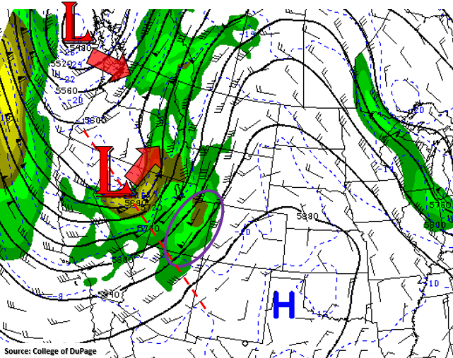
This set up will help spark fairly widespread showers and thunderstorms over the high terrains this afternoon with storm movement towards the northeast. As the storms move off the Southeast Mountains and Front Range, they will start to gain a westerly component. This should bring some rainfall to the Urban Corridor and adjacent plains as well, but at that time, storms will likely become outflow driven and produce more wind and less rainfall. Trailing storms over the mountains will likely help increase 24-hour totals over Central and San Juan Mountains, but only up to moderate rainfall is forecast for the individual storms. Therefore, no flood threat is forecast with the exception of a couple burn areas.
The first threat is for the 416 burn area as isolated totals by morning near the area have the potential to reach 0.75 inches. While this atmospheric set up will likely have that area of higher precipitation closer to the Continental Divide, a Low flood threat has been issued. The second Low threat is issued for the fresh Decker burn area. Although storms will be less widespread over the Southeast Mountains, storms will have the ability to produce rain rates up to 0.50 inches. This could cause flash flooding issues over the burn area if a storm tracks overhead.
Today’s Flood Threat Map
For more information on today’s flood threat, see the map below. If there is a threat, hover over the threat areas for more details, and click on burn areas to learn more about them. For Zone-Specific forecasts, scroll below the threat map.
Zone-Specific Forecasts:
Front Range, Southeast Mountains, Central Mountains, San Juan Mountains, & Northern Mountains:
Best chance for storms this afternoon and evening will be over the mountains. Higher rain rates and totals are expected over the San Juan Mountains, Central Mountains and Front Range near and along the Continental Divide. Wetting storms are forecast to be more widespread over the San Juans and Central Mountains. Max 1-hour rain rates up to 0.50 inches will be possible over the higher terrains with totals up to 0.75 inches by morning in the Central and San Juan Mountains. Stronger thunderstorms will also likely produce some gusty outflow winds/small hail, and more wetting rainfall is forecast later this afternoon and evening. A Low flood threat has been issued for the 416 and Decker burn area. The flood threat will end later this evening with a couple light showers lingering into the night over the San Juans.
Primetime: 1PM to 11PM
Northwest Slope, Grand Valley, San Luis Valley, Southwest Slope, Raton Ridge, Palmer Ridge, Urban Corridor, Southeast Plains, & Northeast Plains:
A few weak storms will be possible over the Southwest Slope and San Luis Valley due to better moisture and lift in the area as storms move in from the south. However, storms will likely produce gusty outflow winds (around 40 mph) as they move into these lower elevations. Max totals up to 0.10 inches will be possible with most areas only receiving a few sprinkles. As storms move into the adjacent eastern plains this afternoon and evening the main threat will be strong winds. Max 1-hour rain rates up to 0.20 inches (north) and 0.15 inches (south) are forecast. Rainfall should come to an end around midnight.
Over the lower elevations of extreme western Colorado and the Southeast Plains increasing surface winds and low relative humidity will combine for critical fire weather. Please tune into your local NWS office for the latest on the Red Flag Warnings that have been issued.
Primetime: 1PM to 1AM