Issue Date: 7/9/2015
Issue Time: 10:30AM
— Moderate flood threat for Palmer Ridge, Raton Ridge and parts of Southeast Plains
— Low flood threat for Grand Valley, Southwest Slope, San Juans, Central Mountains, Front Range, Urban Corridor and Northeast Plains
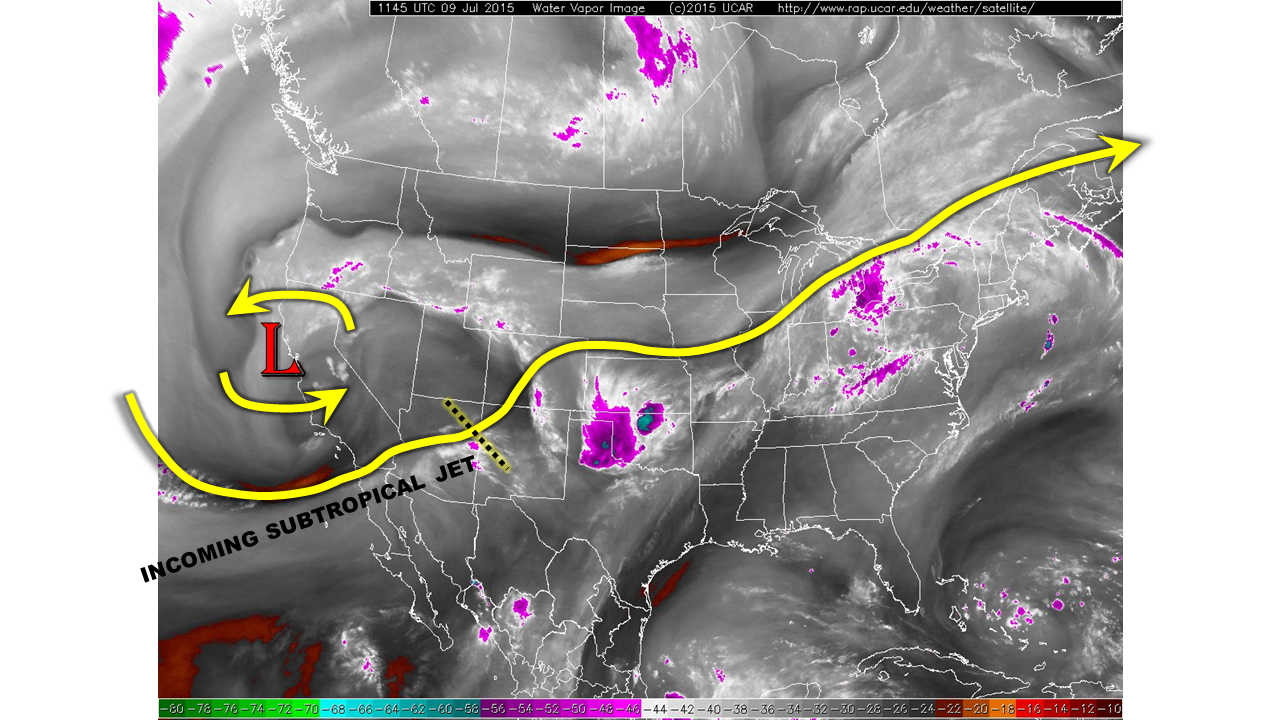
A combination of features will act in tandem to bring another day of heavy rainfall across parts of our state. Some of the players are outlined in the water vapor image below. The most prominent is the upper-level low pressure spinning over California. Over the past 3 days, this disturbance has barely budged, but appears to be gaining speed as it heads east. South and east of this low, a stout subtropical jet is entering Arizona. At the nose, or most downstream part, of the jet is a marked disturbance currently approaching the 4-Corners region. With more sunshine today, the atmosphere will have an easier time heating up, allowing this disturbance to trigger some heavy rain producing storms over Colorado later this afternoon and evening. Along with favorable dynamics, we also note relatively high moisture content. Dewpoint temperatures are once again in the 50s to near 60F statewide. Precipitable water (PW) values have dipped slightly since yesterday, now in the 0.85 to 1 inch range. However, PWs are expected to stay steady or increase throughout the day.
For today, we expect early breaks in clouds to quickly fill in with scattered to widespread thunderstorm activity. First, over and west of the Divide by noon and then east of the Divide shortly thereafter. The highest flood threat today will be over the Palmer Ridge where favorable winds could provide for a window of very heavy rainfall this afternoon and evening. A Moderate flood threat is in place here. A separate Moderate flood threat is also in place for the Raton Ridge and Southeast Plains where a moisture surge may produce some very heavy rainfall later this evening and into midnight. Elsewhere, a Low flood threat is in place for many parts of the state for scattered, short-term thunderstorms capable of producing flash flooding.
Today’s Flood Threat Map
For more information on today’s flood threat, see the map below (hover over threat areas for more details). For Zone-Specific forecasts, jump below the map.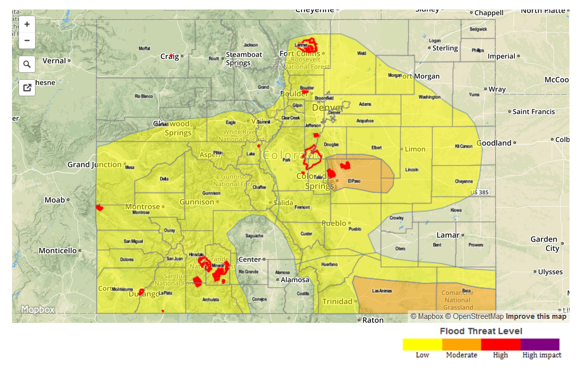
Zone Specific Forecasts
Raton Ridge, Southeast Plains, Southeast Mountains:
Partly cloudy early with scattered to widespread thunderstorm forming by mid-afternoon. One hour rain rates up to 2.4 inches will be possible, with 3-hr rain rates up to 3.5 inches. Storm activity may intensify after sunset as a low-level jet pumps a very moist atmosphere (PWs approaching 1.6 inches) into Colorado. Activity is expected to subside shortly after midnight as instability fades. A Moderate flood threat is in place for parts of the area with a Low threat elsewhere.
Primetime: 2PM through 1AM
Palmer Ridge, Front Range, Urban Corridor, Northeast Plains:
Partly cloudy early, then scattered to widespread thunderstorms forming by early afternoon. Activity will form first over the highest terrain of the Front Range and Palmer Ridge. One hour rain rates up to 1.6 inches will be possible, causing isolated to scattered flash flooding. The highest threat area will be the Palmer Ridge, where south-southeast winds will create a favorable upslope component to the flow. Activity is expected to cease shortly after sunset.
Primetime: 2PM through 10PM
Raton Ridge, Southeast Mountains, San Luis Valley, Central Mountains, Southwest Slope, San Juans:
Partly cloudy with isolated to scattered thunderstorms developing by early afternoon. One hour rain rates up to 0.8 inches will be possible, but flooding is not expected. Activity will subside shortly after sunset.
Southwest Slope, San Juans, Grand Valley, Central Mountains, San Luis Valley:
Mostly sunny early with showers and thunderstorms quickly developing by noon. One hour rain rates up to 0.9 inches will be possible. Given the saturated soils in many parts of the area, this will be enough to induce isolated flash flooding, mud flows and debris slides. Numerous mud flows have been reported over the past several days. A Low flood threat is in place for all areas except for the San Luis Valley. Activity will subside around sunset.
Primetime: 12PM through 8PM
Northwest Slope, Northern Mountains:
Partly cloudy with isolated showers and thunderstorms possible from early afternoon through around sunset. Highest one-hour rain rates will be around 0.6 inches, and no flooding is expected.