Issue Date: Friday, June 12th, 2020
Issue Time: 9:05AM MDT
— Flooding is NOT expected today
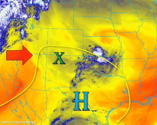
To our west you can see the lift and moisture associated with the next system, which will start to progress eastward today. Over Colorado, mid-level moisture and energy will begin to make its way northward around the High marked below (green “X”). From today into tomorrow, expecting that moisture to increase, which will bring afternoon storms back to the mountains and immediate adjacent plains. However, for the time being, moisture still remains limited. That means only high-based showers and weak, dry thunderstorms are forecast over the southern high terrains this afternoon and evening. With the boundary layer still being quite dry, storms are expected to produce strong winds and limited rainfall.
As the storms rotate clockwise around the high, a storm or two may be able to survive over the western Palmer Ridge due to enhanced convergence over the area. A couple additional storms may form along and south of the Raton Ridge with the southerly surface flow, but storms are expected to move south of the border with the steering flow. Most activity should end a couple hours after the sunsets (decreasing instability), but a weak shower is possible over the San Juan Mountains tonight or early tomorrow morning with mid-level energy rotating around the High. Flooding is not forecast.
Today’s Flood Threat Map
For more information on today’s flood threat, see the map below. If there is a threat, hover over the threat areas for more details, and click on burn areas to learn more about them. For Zone-Specific forecasts, scroll below the threat map.

Zone-Specific Forecasts:
Front Range, Southeast Mountains, Central Mountains, San Juan Mountains, Raton Ridge, & Palmer Ridge:
A couple high-based, dry thunderstorms will be possible this afternoon over the San Juan and southern Central Mountains. With instability a bit higher over the area and a large dew point depression, some strong outflow winds will be possible with storms that form (up to 45 mph). Very isolated max 1-hour rain rates up to 0.25 inches will be possible with most storms producing totals between 0.10 and 0.15 inches. Moisture over the mountains won’t be quite as high east of the Continental Divide, so max 1-hour rain rates will drop to 0.15 inches and coverage will decrease. Gusty winds will still be possible as storms dissipate, but chances for severe winds drop when compared to western high terrains. Storms that form over the western Palmer Ridge and Raton Ridge will be able to produce totals up to 0.25 inches. Flooding is not forecast.
Primetime: 12:30PM to 10PM
Northwest Slope, Grand Valley, San Luis Valley, Northern Mountains, & Southwest Slope:
It’ll be another hot, dry day with temperatures increasing once again. Highs are forecast to reach the upper 80Fs to mid-90Fs over the valleys and the mountain valleys should reach the mid-70Fs. Rainfall is not forecast, but cloud cover will increase from the west with the next system moving east.
Urban Corridor, Southeast Plains, & Northeast Plains:
A dry, hot day is in store for these regions as well with very little cloud cover forecast this afternoon. Highs will reach the upper 80Fs to 90F along the Urban Corridor with mid-90Fs possible over the Southeast Plains.