Issue Date: Tuesday, June 9th, 2020
Issue Time: 9:10AM MDT
— Flooding is NOT expected today
Much cooler temperatures are forecast across the state today behind the powerful cold front that brought rainfall and snow to the higher elevations. The system, and associated ongoing rainfall/snow, can be seen over Colorado in the visible satellite imagery below. Further to our east, you can see the remnants of Cristobal. Excepting the precipitation to track eastward throughout the day as the Low tracks into Kansas. Behind the low, it will start to clear as seen by the cloudless conditions over the western border, and stable conditions are forecast.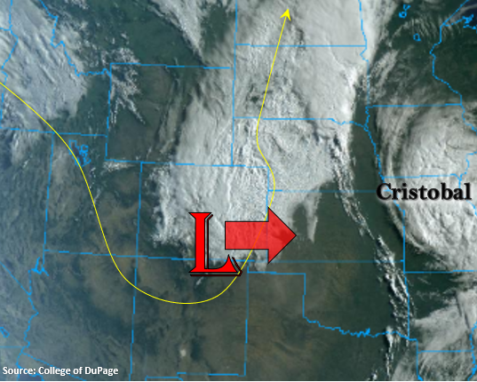
Lack of instability will keep rain rates below flood threat criteria over the plains, although some isolated 24-hour accumulations up to 1.20 inches will be possible over the Northeast Plains due to favorable upper dynamic support and plenty of low-level moisture. This will also be a nice wetting rainfall for the drought area over the Southeast Plains, and totals by morning are forecast to (generally) be in the 0.50 to 0.75 inches range. As anticipated, flooding is not expected today. Additionally, a High Wind Warning has been issued for the eastern plains with northerly surface winds forecast in the 30 to 40 mph range and gusts between 60 and 70 mph due to the strengthening system. Over the San Luis Valley, drying paired with northwest winds will cause Red Flag Warning criteria from noon to 8PM this evening. Tune into NWS Pueblo for the latest on the fire weather conditions.
Today’s Flood Threat Map
For more information on today’s flood threat, see the map below. If there is a threat, hover over the threat areas for more details, and click on burn areas to learn more about them. For Zone-Specific forecasts, scroll below the threat map.

Zone-Specific Forecasts:
Southeast Plains & Northeast Plains:
It’ll be windy and wet. A High Wind Warning is in effect until 6PM this evening with northwest winds forecast between 30 and 45 mph and gusts up to 65 mph. Overall, this will be a nice, wetting even for the eastern plains and drought region in the Southeast Plains. Totals will be greatest over the Northeast Plains with 24-hour totals up to 1.20 inches possible. Generally, totals will be around 0.75. Over the Southeast Plains, the moderate rainfall will won’t be as widespread, but still, 24-hour totals between 0.50 and 0.75 inches can be expected. Flooding is not forecast.
Primetime: ongoing to 6PM
Northwest Slope, Grand Valley, Central Mountains, San Juan Mountains, Northern Mountains, & Southwest Slope:
Continued clearing is expected today with cooler high temperatures forecast behind the trough. Lows overnight dropped to below freezing over the mountains and valleys, which was too be expected with such a strong system. Expecting overnight low temperatures to drop to around freezing for the Northwest Slope and high-mountain valleys again, so prepare accordingly. Stability behind the front will keep rainfall out of the forecast, and clear skies are expected by this afternoon.
Front Range, Southeast Mountains, San Luis Valley, Raton Ridge, Palmer Ridge, & Urban Corridor:
Precipitation is starting to come to an end over these regions as the system moves east and subsidence fills in. By later this afternoon, expect skies to clear with highs reaching the mid-60Fs over the lower elevations and 50Fs for the mountain valleys. Enjoy the break from the heat as temperatures rebound quickly by Thursday and Friday afternoon. Also forecast today are some gusty, northerly winds. Winds will pick up by noon and are expected to bring critical fire conditions to the southern portion of the San Luis Valley.
Primetime: ongoing to 11AM