Issue Date: Monday, June 8th, 2020
Issue Time: 10:15AM MDT
— Flooding is NOT expected today
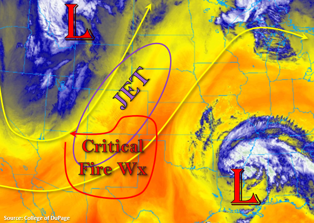
It’s going to be a windy day across the state with the jet overhead and a lee cyclone developing over eastern Colorado. This will mean critical fire weather for southern and eastern Colorado as relative humidity also drops into the teens and single digits. Please visit your local NWS office for Red Flag Warning details.
As far as rainfall, it has really dried out since Saturday with southwesterly flow aloft. PW was measured at 0.45 and 0.30 inches at Denver and Grand Junction, respectively. There is some moisture that is expected to move into northwest Colorado and spread eastward across northern Colorado today with the trough. This will help spark some scattered, high-based storms along a cold front that moves into northwest and central Colorado. Expecting severe winds to be the main threat this afternoon with rain rates becoming more efficient this evening.
That increase in efficiency is due to a second surge of northerly air (colder front) moving south overnight and helping return low level moisture. With the jet/lift overhead tonight, maximized dynamics will create widespread snow and showers for the mountains and I-25 corridor. Storms are expected to continue through tomorrow morning as the trough moves east into the plains. Rainfall is forecast to be gradual enough that flash flooding should be avoided. Additionally, a High Wind Warning has been issued for eastern Colorado from 6PM this evening to 3AM as winds in the 30 to 40 mph range with gusts up to 60 mph are expected to accompany the frontal passage (winds from the north). Behind the front, very cold temperatures are forecast for the higher elevations, so the snowline could drop to around 7,000 feet tonight. This will cause snow accumulation on roads starting around 8,500 feet. Hazardous overnight driving conditions are expected over mountain passes (especially near the Continental Divide), so please use extra caution with the icy conditions. If you are backpacking or camping, be prepared for very cold overnight temperatures.
Lastly, some heavier rainfall will be possible over the northeast corner of the state tonight due to an MCS feature that forms in conjunction with upper dynamics behind the cold front. At this time, the heaviest rainfall looks to be over Nebraska, but isolated totals up to 1.50 inches will be possible by morning. These totals will likely be over a small enough area (Sedgwick and Phillips Counties) that no flood threat is needed.
Today’s Flood Threat Map
For more information on today’s flood threat, see the map below. If there is a threat, hover over the threat areas for more details, and click on burn areas to learn more about them. For Zone-Specific forecasts, scroll below the threat map.

Zone-Specific Forecasts:
Northwest Slope, Grand Valley, San Luis Valley, & Southwest Slope:
Going to put the zone-specific forecasts in order of rainfall timing with the Northwest Slope and Grand Valley first. Storms are expected to form along a weak cold front with the main threat being severe winds from storms. Max 1-hour rain rates around 0.15 to 0.20 inches will be possible over the higher elevations. Storms should move into the mountains later this evening. Flooding is not expected. Over the Southwest Slope and San Luis Valley a Red Flag Warning has been issued for westerly surface winds in the 15 to 25 mph range with gusts up to 45 mph possible.
Primetime: 12PM to 10PM
Central Mountains, San Juan Mountains, Northern Mountains, Front Range, & Southeast Mountains:
Storms will start to develop over the Northern Mountains and northern Front Range around 5PM this evening. Accumulation is expected to continue overnight and increase south along and near the Continental Divide. With the passage of the cold front, snowfall is expected over the higher mountain passes and areas greater than 8,500 feet in elevation. Guidance indicates that several inches of snow are possible favoring western facing slopes by tomorrow morning along the Divide (pockets of 7-10+ inches), but most areas will only receive between 2-5 inches. Flooding is not expected due to most areas turning to snow with the frontal passage.
Primetime: 5PM to 4AM
Raton Ridge, Palmer Ridge, Urban Corridor, Southeast Plains, & Northeast Plains:
Moderate overnight rainfall is possible over the Urban Corridor, Palmer Ridge and Northeast Plains behind the cold front overnight. Totals by tomorrow morning should range from 0.50 to 0.75 inches with isolated areas over the northeast corner possibly reaching 1.50 inches. Further south along the I-25 corridor, totals up to 0.50 inches will be possible. Flooding is not forecast due to gradual rain rates, although some local field ponding may be possible over the northeast corner of the state if storms back build into the area. The area isn’t large enough and confidence isn’t high enough to warrant a threat at this time.
Primetime: 9PM to ongoing