Issue Date: Monday, June 1st, 2020
Issue Time: 2:40PM MDT
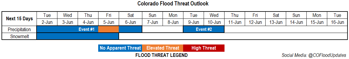
Valid Dates: 6/2 – 6/16
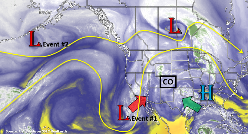
A look-alike omega pattern from last week’s FTO has set itself up with an elongated ridge extending from Utah to the Midwest. On the left side of the High, clockwise motion continues to pull moisture northward from the Gulf of Mexico (green arrow). While the higher PW values are to our southeast, there is still plenty of moisture trapped under the ridge to help produce daily afternoon storms over the state this week. Flow becomes more westerly aloft by tomorrow, which should help mix out the surface moisture as more dry air is entrained; thus, there is No Apparent Threat for the first part of Event #1.
By the week’s end, the Low off the coast off CA starts to eject northward. The ECMWF has a more northward track of the Low, and as the low lifts on Saturday, it quickly weakens. This would lead to a drier scenario later this week into this weekend. However, the GFS has the low ejecting more to the northeast, and with higher moisture, which would bring more widespread showers and a heavy rainfall threat to the state on Friday. So for now, there is only an Elevated Threat for Event #1 on Friday. The models will likely come into better agreement by Thursday, so be sure to tune back in as there may be an upgrade to a High threat if the GFS scenario looks more likely.
Increased southwest flow behind the Low will keep the weekend rather dry with the ridge access well to our east. Temperatures will be hot, too, with highs nearing the triple digits over the Southeast Plains. Antcipating an increase in fire danger over weekend with an uptick in surface winds (jet overhead) combining with a drier air mass. The Low over the Pacific Northwest then begins to traverse eastward to our north on Tuesday and Wednesday, which will push a cold front through the state and may help return low level moisture for storms. At this time, there is an Elevated flood threat for Event #2 during this period.
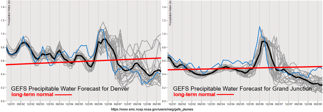
As expected by the GEFS, there is a large spike in moisture across the state as the Low tracks to the northeast and clips the Northwest Slope on Friday. Clearly, this is the most notable feature in the plumes below without much uncertainty from model runs. Also, notice the above average to average PW values to start this week. This shows there is plenty of moisture for storms to fire over the mountains each afternoon, although activity looks to decrease Tuesday into Thursday. Steering flow also intensifies tomorrow, so except the westerly flow to carry storms off the mountains into the adjacent plains and decrease the flood threat. As mentioned above, there is a quick decrease in moisture as the southwest flow begins behind the Low (Event #1). This will keep the weekend mostly, if not all, rain-free and increase fire danger as 10-meter winds increase in to the 15 to 25 mph over western Colorado in the GEFS (not shown).
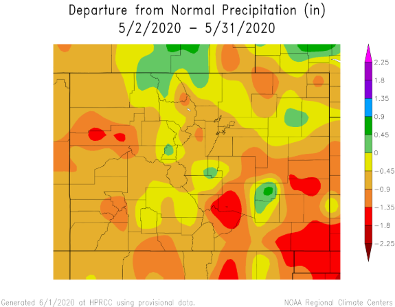
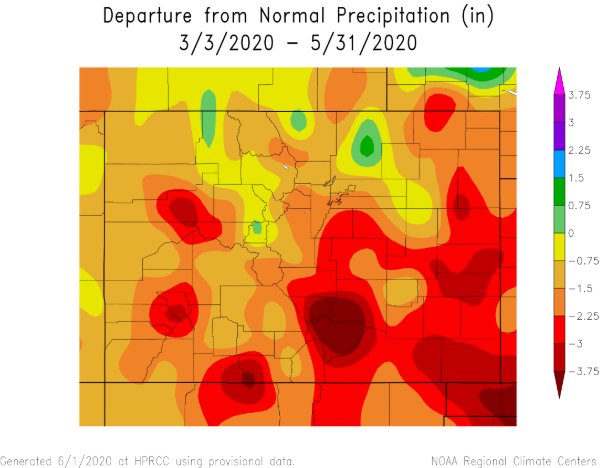
Also, I wanted to take a quick peek at the May precipitation across the state, since it is the end of the month and start of meteorological summer. It has been very dry over the majority of the state with the largest departures from normal precipitation over the southeast border counties and lower elevations of western Colorado (top image). From March to May (meteorological Spring; bottom image), the Southeast Plains has seen 3.5 inches or greater below average precipitation. This is also true for the Conejos/Archuleta County area and western slopes of the Central and San Juan Mountains. It’s no surprise these areas have quickly fallen into the D3 and D2 drought categories. The year-to-year variability in Colorado’s precipitation never ceases to impress me.
Event #1: Tuesday – Saturday (6/2–6/6)
Elevated Threat as moisture and dynamics peak on Friday with current GFS runs pulling the Low to the northeast, which would bring widespread showers and the flood threat back to Colorado for the day.
An axis of instability and convergence looks to set up over the eastern plains tomorrow with a surface low. Higher areas of CAPE (northeast corner) may remain capped, but with dew points in the 50Fs on this side of the surface low, heavy rainfall over a small area is possible. CAPE further south is quite a bit less and with dry low levels, heavy rainfall is not anticipated. Best convergence (chance of rainfall) will be on the low’s south side (Southeast Plains), and the main threat will be strong outflow winds and small hail. Mountain storms look to favor the Southeast Mountains, but westerly flow aloft will likely scour out a lot of moisture. Thus, there is No Apparent flood threat. Wednesday into Thursday, coverage of storms over the mountains looks to be even less. We’ll have to see where the dry line sets up each afternoon over the eastern plains. If it remains within Colorado, and storms can make it to the border counties, some moderate rainfall may be possible. Friday, the threat increases with the aforementioned low moving northeast. There is still a lot of uncertainty, but the map below will illustrate the GFS solution (higher moisture and better dynamics on Friday).
Event #2: Tuesday – Wednesday (6/9-6/10)
No Apparent Threat as the Pacific low becomes an open wave and passes to our north.
Don’t want to get into too many details this far out, but storm chances ramp up as the next shortwave influences the region next week. Right now, Tuesday looks to be the most active as a cold front pushes through the state. There looks to be a nice break from the heat from earlier in weekend after the front passes. Guidance is showing temperatures returning to more seasonable values behind it, but I wouldn’t put too much weight into the models yet. There could easily be an increased heavy rainfall and severe weather threat as this event nears, so be sure to tune back into the FTO. A map has not been drawn for this event due to low confidence in the details/guidance not showing a half inch of rain for this event over any one area.