Issue Date: Monday, May 25th, 2020
Issue Time: 9:00 AM MDT
Summary:
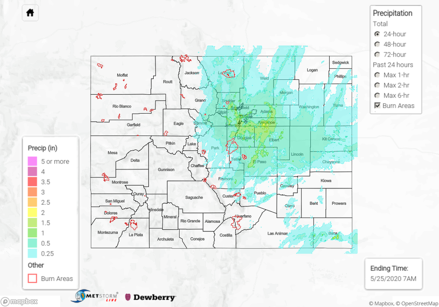
A large, upper-level trough moved slowly overhead yesterday, providing sufficient dynamic forcing for widespread showers and thunderstorms east of the Continental Divide. Showers began early in the day and increased in coverage and intensity through the afternoon and evening hours, diminishing slowly after sunset. A few isolated showers continued into the early morning hours over the far Southeast Plains. The rainfall proved beneficial, with more than a half-inch of rain being reported at many locations along/east of the Front Range without resulting in flash flooding. A few of the higher reports from CoCoRaHS observers (as of 7 AM MDT) include:
1.65 inches (Douglas County)
1.45 inches (Jefferson County)
1.35 inches (El Paso County)
1.28 inches (Elbert County, Boulder County)
1.24 inches (Denver County)
1.14 inches (Fremont County)
1.12 inches (Arapahoe County)
1.02 inches (Adams County)
West of the Continental Divide, showers were more isolated, confined mainly to the highest elevations of the Central Mountains, Northern Mountains, and San Juan Mountains. Above 8000 feet, most of this precipitation fell as snow.
Flooding was not reported on Saturday. For rainfall estimates in your area, check out our State Precipitation Map below.
Click Here For Map Overview