Issue Date: 5/16/2020
Issue Time: 8:10 AM
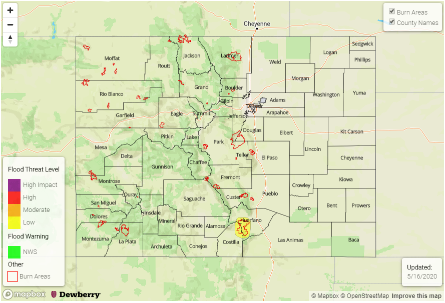
— LOW Flood Threat is Forecast Today for the Spring Creek Fire Burn Scar
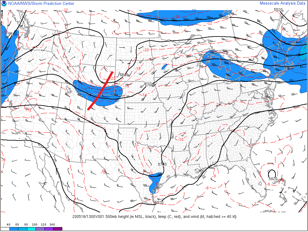
A disturbance aloft (red line in image below) will swing across Colorado today, with ridge of high pressure building in quickly behind it. At the surface, an exiting cool front will leave a bit of moisture in its wake across eastern Colorado, providing the fuel for showers/thunderstorms this afternoon and tonight along/east of the Continental Divide. The best coverage will occur south of I-70 and east of the Front Range and Southeast Mountains, with more isolated coverage to the north. West of the Continental Divide, the high-pressure ridge will usher in drier and warmer conditions, resulting in a pleasant afternoon for most.
Spring Creek Fire Burn: Scattered thunderstorms will rumble near the burn scar, with dewpoints in the 30s. This is enough moisture to produce rain rates in the 0.15-0.35 inches/hour range. There is a chance for outflow from nearby thunderstorms to push dewpoints higher, into the 40s, by this evening. This additional moisture would be enough to produce rain rates of 0.5 inches/hour, and thus the issuance of the low flood threat.
Today’s Flood Threat Map
For more information on today’s flood threat, see the map below. Hover over the threat areas for more details and click on burn areas to learn more about them. For Zone-Specific forecasts, scroll below the threat map.
Zone-Specific Forecasts
Front Range, Southeast Mountains, Urban Corridor, Palmer Ridge, Northeast Plains, Southeast Plains, and Raton Ridge:
Along and South of I-70: Scattered showers and thunderstorms expected, first developing over the higher terrain and Palmer Ridge, then spreading east-southeastward over the plains. A couple storms will push marginally severe limits, with hail up to 1 inch in diameter and strong winds up to 70 mph. Rain rates will generally be in 0.2-0.4 inches/hour range, with max rain rates of 0.5-0.75 inches/hour over the Southeast Plains. Timing: 1 PM – 11 PM, with one or two lingering storms over the Southeast Plains into the early morning hours.
North of I-70: Showers/thunderstorms will be more isolated than areas to the south, with the best chance for storms near the foothills and out over the Northeast Plains. Rain rates will generally be in the 0.1-0.3 inches/hour range, with max rates over the Northeast Plains around 0.6 inches/hour. Timing: Noon – 9 PM
Northwest Slope, Northern Mountains, Grand Valley, Central Mountains, Southwest Slope, San Juan Mountains, and San Luis Valley:
Drier and warmer as the upper ridge of high pressure builds over the area. Most areas will see plenty of sunshine and high temperatures near, or just above, average for the date. A couple isolated showers/weak thunderstorms will rumble over the San Juan Mountains and adjacent San Luis Valley where better moisture will hang on and the disturbance aloft will be last to leave. Rain rates will be less than 0.2 inches/hour.
Timing: 1 PM – 10 PM