Issue Date: Friday, May 15th, 2020
Issue Time: 9:05AM MDT
— A LOW flood threat has been issued for the Northeast Plains, Palmer Ridge and Southeast Plains
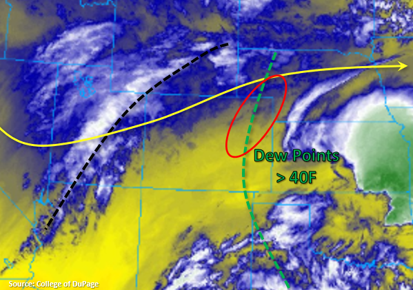
An overnight cold front has helped hold moisture in place over the state. PW was again measured this morning at 0.60 inches and 0.48 inches for Denver and Grand Junction, respectively. The atmosphere will be better suited to produce some stronger storms this afternoon over eastern Colorado due to a boost in instability and area of convergence (red circle below). Storms will also be supported by upper level flow and a stronger shortwave moving through the west and southwest flow. All these features will combine to help produce some severe thunderstorms over the far northeast corner of the state. The main threats will be large hail and strong winds as the storms form an MCS along that line of convergence by early this evening.
Expecting storms to fire first over the northwest quadrant of the state just after noon. Best chance for accumulations will again be over the higher elevations of the Northwest Slope, Northern Mountains and Central Mountains along the Divide. To the east, development will favor the Front Range with more scattered storms over the Southeast Mountains and Raton Ridge early this afternoon. Although moisture will still not be too impressive, trailing and back-building storms will cause an increase in accumulation over some locations in an hour or two. Additionally, higher moisture east of the green line below is expected to increase storm totals. Thus, a Low flood threat has been issued with the flood threats being isolated arroyo and small stream flash flooding, field ponding and low-land flooding. A couple light showers may linger over the Southeast Plains overnight, but they should start to break up tomorrow morning. Other rainfall activity across the state should end by midnight.
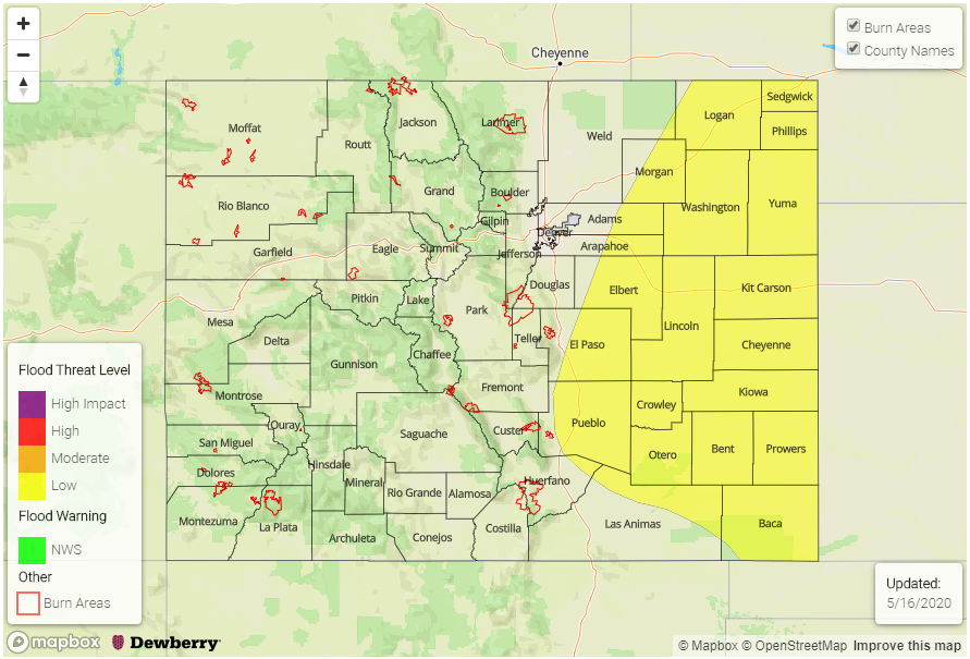
Today’s Flood Threat Map
For more information on today’s flood threat, see the map below. If there is a threat, hover over the threat areas for more details, and click on burn areas to learn more about them. For Zone-Specific forecasts, scroll below the threat map.
Zone-Specific Forecasts:
Front Range, Southeast Mountains, Urban Corridor, Northeast Plains, Palmer Ridge, Southeast Plains, & Raton Ridge:
Storms the west will have less available moisture, so totals will be a bit less than out east. Max 1-hour rain rates up to 0.75 inches will be possible in the foothills and along the Urban Corridor with totals increasing to 1.20 inches along the Palmer Ridge. Out east near the border, max 1-hour rain rates up to 1.75 inches will be possible. Thus, a Low flood threat has been issued. Severe storms this afternoon could produce some strong gusts (greater than 50 mph) and large hail (up to 1.5 inches in diameter), but these threats should be only over the northeast corner of the state. Lingering overnight storms on the Southeast Plains could produce some high, isolated totals (around 2 inches) by morning.
Primetime: 12PM to 5AM
Northwest Slope, Grand Valley, Central Mountains, & Northern Mountains:
Should see an uptick in coverage of storms this afternoon and evening as the stronger shortwave moves through. Best chance for accumulation will be in the Northern Mountains and near/along the Roan Plateau and Flat Top region. Isolated totals just under 0.50 inches will be possible by morning in the Northern Mountains. Small hail is also possible for the strongest storms that form further north. Gusty winds will also be likely under most storms that do form, including the more scattered storms over the Grand Valley and western Central Mountains.
Primetime: 12PM to 10PM
San Juan Mountains, Southwest Slope, & San Luis Valley:
These areas will stay dry this afternoon with highs in the mid to upper 70Fs. Surface winds will again be under critical fire weather criteria, so there is no Red Flag Warning. Lows overnight are forecast to drop into the 40Fs for the lower elevations and between 35-40F for the mountain valleys.