SPM 05-14-2020: Overnight Storms for the Fort Collins Area

Issue Date: Thursday, May 14th, 2020
Issue Time: 9:05AM MDT

Summary:

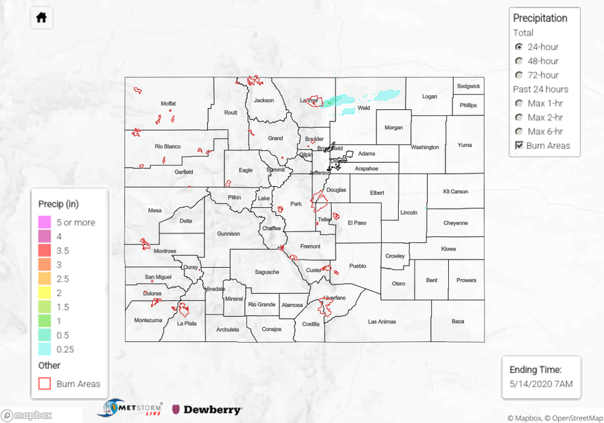
The biggest surprise yesterday were the late night and early morning storms over the Fort Collins/Greeley area. Behind a cold front, moisture had returned to the area. A subtle shortwave moving through the area helped spark the thunderstorms, which also produce small hail. The mesonet in Fort Collins reported up to 0.98 inches over the 24-hour period, although the small hail may have contaminated this reading. Either way, impressive totals. Weak rainfall was also sparked by this same shortwave over the Northern Mountains with totals estimated up to 0.15 inches. Elsewhere, it was a quiet day with dry conditions. Thankfully no new fires were reported, as of this morning, despite extreme fire conditions across southern Colorado.

For precipitation estimates in your neighborhood last night and over the last 72-hours, scroll down to the State Precipitation Map below.

Click Here For Map Overview

The map below shows radar-estimated, rainfall gage-adjusted Quantitative Precipitation Estimates (QPE) across Colorado. The map is updated daily during the operational season (May 1 – Sep 30) by 11AM. The following six layers are currently available: 24-hour, 48-hour and 72-hour total precipitation, as well as maximum 1-hour, 2-hour and 6-hour precipitation over the past 24 hour period (to estimate where flash flooding may have occurred). The 24-hour, 48-hour and 72-hour total precipitation contain bias corrections that are not disaggregated into the hourly estimates, so there will likely be some differences. The accumulation ending time is 7AM of the date shown in the bottom right corner. Also shown optionally are vulnerable fire burn areas (post 2012), which are updated throughout the season to include new, vulnerable burn areas. The home button in the top left corner resets the map to the original zoom.