Issue Date: 7/6/2015
Issue Time: 10:00 AM
A MODERATE FLOOD THREAT HAS BEEN ISSUED FOR PORTIONS OF THE RATON RIDGE, SOUTHEAST PLAINS, SOUTHEAST MOUNTAINS, AND CENTRAL MOUNTAINS. A LOW FLOOD THREAT HAS BEEN ISSUED FOR PORTIONS OF THE URBAN CORRIDOR, PALMER RIDGE, FRONT RANGE, SOUTHEAST PLAINS, NORTHEAST PLAINS, NORTHERN MOUNTAINS, NORTHWEST SLOPE, CENTRAL MOUNTAINS, GRAND VALLEY, AND SOUTHWEST SLOPE.
The once strong upper-level ridge has been flattened out by the upper-level trough that continues shifting eastward across the US/Canada border. Attendant of this upper-level trough was surface cool front that continues to move south across Colorado, with upslope flow developing behind it. Surface dewpoints continue to run high statewide; readings are in the upper 50s and low 60s across lower elevations of eastern Colorado, mid-to-upper 50s across the valleys of western Colorado, and in the 40s across the High Country. Coupled with this surface moisture is plenty of deep, subtropical moisture, which has pushed precipitable water values above 1 inch at each of the normal 4 reporting stations (Boulder, Grand Junction, Pueblo, and Shriever AFB).
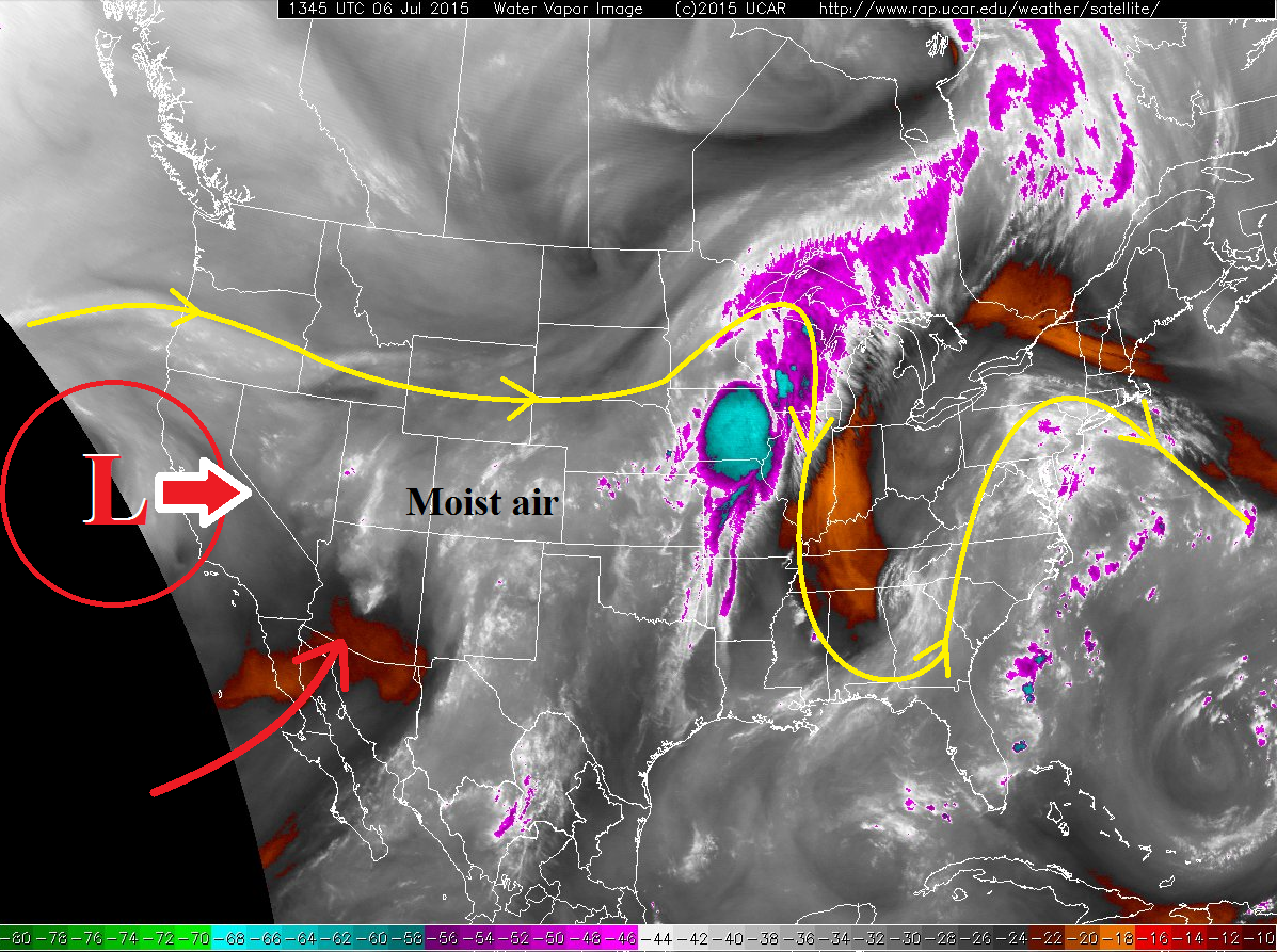
The moist, southwesterly flow will continue through this afternoon, as the upper-level low off the coast of California continues to push onshore. Embedded in the general flow is a couple of weak disturbances that will slide across the state this afternoon and overnight, providing a bit of focus for thunderstorm activity. However, orographics and daytime heating will arguably be the main focus for thunderstorm development this afternoon and evening.
The best coverage of showers and thunderstorms during this forecast period will be across the Central Mountains, Front Range, Southeast Mountains, Urban Corridor, Raton Ridge, and Southeast Plains. These zones will be the focus for heavy rain concerns today, as well. Isolated showers and thunderstorms are expected across all other zones, including the Northeastern Plains, Palmer Ridge, San Luis Valley, Northern Mountains, Northwest Slope, San Juan Mountains, Grand Valley, and Southwest Slope. For more details, check out the Zone-Specific discussions below the threat map.
Today’s Flood Threat Map
For more information on today’s flood threat, see the map below (hover over threat areas for more details). For Zone-Specific forecasts, jump below the map.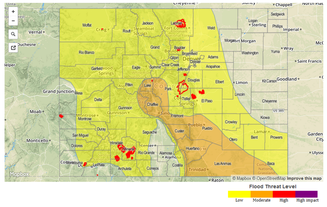
Zone-Specific Forecasts
Urban Corridor, Palmer Ridge, and Northeast Plains:
Isolated-to-scattered showers and thunderstorms expected this afternoon and into the late evening hours, with a few lingering showers overnight. Due to upslope flow behind the surface cool front, the best relative chances for heavy rain will be along and west of I-25 and into the foothills. Maximum rain rates will be 0.8-1.4 inches/hour.
Timing: 11 AM – 10 PM will be primetime, but expect a few showers and a weak thunderstorm or two to continue into the early morning hours tomorrow.
Front Range, Central Mountains, Southeast Mountains, Southeast Plains and Raton Ridge:
Scattered showers and thunderstorms are likely throughout the day and into the overnight hours, with a few showers continuing into the early morning hours tomorrow. With the significant amount of moisture in place across the area, heavy rain is likely, and flash flooding/mudslides are a concern, especially for areas that have experienced rainfall the past few days. Fairly quick storm motions will help mitigate the flood risk, but a moderate flood threat is warranted. Maximum rain rates will 1.5-2.5 inches/hour over the Raton Ridge and Southeast Plains, and 1.0-1.6 inches/hour over the Front Range, Central Mountains, and Southeast Mountains.
Timing: 11 AM – Midnight, with a few showers and thunderstorms continuing into the early morning hours.
Northern Mountains, Northwest Slope, San Luis Valley, San Juan Mountains, Southwest Slope, and Grand Valley:
Isolated-to-scattered showers and thunderstorms expected, mainly over the higher terrain and adjacent valleys. Precipitable water values have backed off a bit, but will still be sufficiently high (0.75-1.0 inch) to produce efficient rainfall. Storm motions will help mitigate flood risk, but areas that have received rainfall over the past few days, and streams that are flowing near bank-full, will bear monitoring for issues with additional rainfall. Rain rates will typically be 0.8-1.25 inches/hour under thunderstorms, with one or two stronger thunderstorms holding the potential to produce rain 1.0-1.6 inches/hour.
Timing: 11 AM – Midnight, with a few showers continuing over the higher terrain into the morning hours.