Issue Date: Monday, May 11th, 2020
Issue Time: 9:30AM MDT
— A LOW flood threat has been issued for the Lake Christine burn area
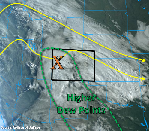
Moisture from the south has returned to the state, which can be seen by the abundant cloud cover in the image below. Precipitable Water was measured at 0.68 inches in Grand Junction this morning, which is very much above normal for this time of year. This moisture, paired with a vorticity maximum (lift) moving through the ridge pattern, helped produce some overnight rainfall for western Colorado and the mountains. Expecting this rainfall to continue throughout the day with increased intensity due to the stronger moisture in place. A couple thunderstorms are also possible over western Colorado and the mountains as instability increases with day time heating. Mountain valleys will likely see no to light accumulations and brief windy conditions.
As storms move off the Southeast Mountains and Front Range, expecting accumulation to favor the Palmer and Raton Ridges. Southeast surface flow will also help pond higher moisture over the Southeast Plains, so if storms make it into this area, a couple strong storms can be anticipated. The Northeast Plains will remain capped (no rainfall) with much below average temperatures.
Overall, this is a classic Colorado spring weather system with an assortment of precipitation types. Not too worried about saturated soils over western Colorado due to the recent dryness, spring green up, and low accumulations from yesterday. Also, the more stratiform nature of the general rainfall pattern should keep the flood threat low statewide. With the warmer temperatures, a lot of the low elevation snow pack has melted out, so rain on snow isn’t a huge concern either. However, there is the possibility for afternoon thunderstorms to spring up over the Central Mountains, and one of these stronger storms tracking over the Lake Christine burn area. A Low flood threat has been issued for this burn area for this reason.
Today’s Flood Threat Map
For more information on today’s flood threat, see the map below. If there is a threat, hover over the threat areas for more details, and click on burn areas to learn more about them. For Zone-Specific forecasts, scroll below the threat map.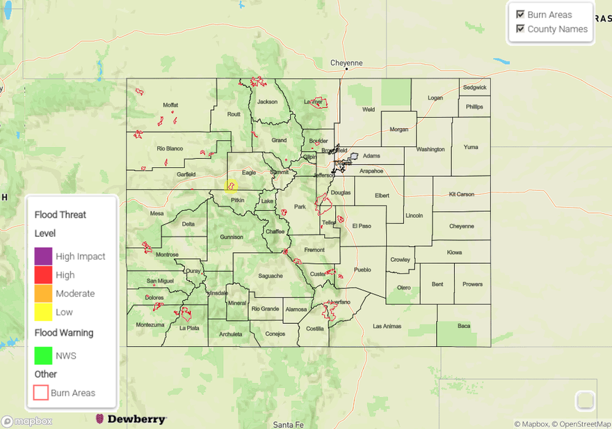
Zone-Specific Forecasts:
Urban Corridor, Northeast Plains, Palmer Ridge, Southeast Plains, & Raton Ridge:
Cold start to the morning with the Northeast Plains reaching near freezing values. This area should remain rain free today with below average high temperatures. Increasing southeast surface winds will help pull some higher moisture values into the Southeast Plains. Expecting storms to favor the Palmer and Raton Ridges as the move off the mountains. A stronger thunderstorm or two may be possible over the far Southeast Plains. One to two hour totals up to 0.6 inches (west) and 1 inch (east) are forecast, but flooding is not expected.
Front Range, Northern Mountains, Central Mountains, Southeast Mountains, San Juan Mountains, & San Luis Valley:
Expecting rainfall coverage to grow throughout the day with intensity increasing from yesterday. Mountain valleys should remain dry, which includes the San Luis Valley. Brief gusty winds may also be possible in these areas. The snow line is forecast between 10K to 11K with 2-4 inches expected by morning. Generally, more stratiform rain is forecast with totals by morning between 0.5 and 0.75 inches. Isolated totals up to 1 inch may be possible over the Front Range and Northern Mountains near the Continental Divide. Over the western high terrains spotty afternoon thunderstorms are anticipated with max 1-hour rain rates up to 0.6 inches. If one of these storms tracks over the Lake Christine burn area, flash flooding, mud flows and debris slides will be possible. A Low flood threat has been issued for this reason.
Northwest Slope, Grand Valley, & Southwest Slope:
Coverage of rainfall and afternoon storms will be more spotty over these regions. Max 1-hour rain rates up to 0.6 inches will be possible over the high elevations in these regions under the stronger storms. Overall, totals will be between 0.10 and 0.25 inches with brief gusty winds possible. Flooding is not forecast.