Issue Date: 5/10/2020
Issue Time: 8:10 AM
— Flooding is NOT expected today
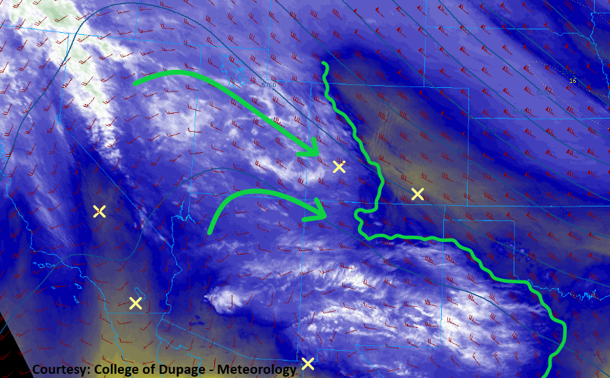
The northwesterly flow aloft that has controlled the forecast the last few days will begin to give way to more westerly flow today. This will allow mid-level moisture to return from the west this afternoon/evening (green arrows in image below), and then south/southwesterly flow in the low-levels will start to bring in moisture from the south tonight and tomorrow. Today’s moisture return will mainly prime the atmosphere for tomorrow, but there will be enough to fuel scattered high-based showers, and perhaps a thunderstorm or two.
Generally speaking, the scattered showers/weak thunderstorms will remain over the High Country, especially west of the Continental Divide, where the moisture will be first to return. The activity will be high-based, with low-level moisture still lacking, resulting in mainly gusty winds and light, if any, rainfall reaching the surface. Bigger changes come overnight and tomorrow morning, when a better surge of moisture reaches western Colorado and the added instability brings a few more claps of thunder and better rainfall. Still, not enough to result in a flood threat during this forecast period.
Today’s Flood Threat Map
For more information on today’s flood threat, see the map below. Hover over the threat areas for more details and click on burn areas to learn more about them. For Zone-Specific forecasts, scroll below the threat map.

Zone-Specific Forecasts
Urban Corridor, Palmer Ridge, Northeast Plains, Southeast Plains, and Raton Ridge:
Sunshine and warmer temperatures will dominate the forecast today, with clouds increasing overnight and tomorrow morning as the moisture returns. There is a chance for an isolated thunderstorm or two over the Raton Ridge and far Southeast Plains this afternoon/tonight as surface moisture tries to cross the Raton Ridge into southern Colorado. Rainfall rates from any activity will be less than 0.25 inches/hour.
Timing: 3 PM – 9 PM
Northwest Slope, Northern Mountains, Grand Valley, Central Mountains, Front Range, Southeast Mountains, Southwest Slope, San Juan Mountains, and San Luis Valley:
Today begins on a mostly sunny note, but moisture is making its return today, and clouds will increase along with it as the day goes on. Scattered, high-based showers/weak thunderstorms will rumble across the region, especially west of the Continental Divide, beginning early this afternoon and continuing into tomorrow. Rain rates will generally be light, as moisture will still be lacking in the low-levels during this forecast period. The main impacts from any activity will be gusty winds and lightning. Rain rates will be less than 0.2 inches/hour this afternoon/evening, with better rainfall to the tune of 0.2-0.4 inches/hour tomorrow morning as the better moisture surge arrives.
Timing: 1 PM – 11 AM for the Southwest Slope, San Juan Mountains, and San Luis Valley; 3 PM – 11 AM for Grand Valley and Central Mountains, 4 PM – 11 AM for the Northwest Slope and Northern Mountains; 3 PM – 10 PM for the Southeast Mountains; 4 PM – Midnight for the Front Range