Issue Date: Thursday, May 7th, 2020
Issue Time: 8:30AM MDT
— Flooding is NOT expected today
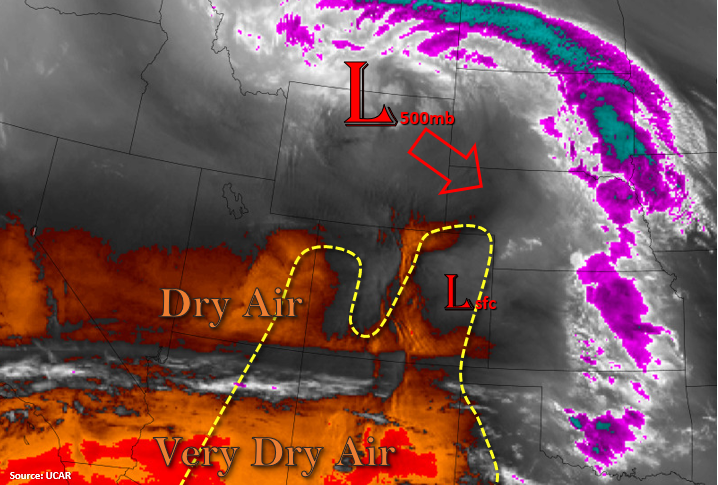
Today’s main weather story will again be Elevated and Critical fire weather for the state. Marked in yellow below on the water vapor imagery are the main areas of concern. A strong upper level trough (to our north) will start to move to the southeast throughout the day, and a tightening surface pressure gradient/upper level jet with that feature will increase the wind speed. The imagery below is also showing very dry conditions across the state, and the moisture associated with the approaching trough is well to our north and east (white, purple, and blue). That translates to low relative humidity, and combining with dry fuels, increased fire danger. Very light showers may be possible over the Front Range overnight as a cold front drops through the area with an increase in cloud cover to the east. Flooding is not forecast.
Today’s Flood Threat Map
For more information on today’s flood threat, see the map below. If there is a threat, hover over the threat areas for more details, and click on burn areas to learn more about them. For Zone-Specific forecasts, scroll below the threat map.
Zone-Specific Forecasts:
Front Range, Palmer Ridge, Urban Corridor, Northeast Plains, Raton Ridge, & Southeast Plains:
Over eastern Colorado, surface winds will shift and increase as the first boundary moves through by late morning making the winds more northerly. Then, colder air moves through tonight (cold front) as there is another push of stronger, northerly winds. This will knock down high temperatures statewide tomorrow, and it may produce some light showers and cloud cover as it pushes southward overnight along the Front Range. Moisture will be limited, so accumulations will generally stay under 0.15 inches. Fire danger will decrease with the cooler temperatures, even though winds will continue to be in the 15 to 25 mph range overnight for the eastern plains. Be sure to tune into your local NWS office for the latest.
Primetime: 1AM to 5AM
Northern Mountains, Northwest Slope, Grand Valley, Southwest Slope, San Luis Valley, Central Mountains, Southeast Mountains, & San Juan Mountains:
For western Colorado, surface winds will be from the northwest with more westerly surface winds over the mountains. Snowpack should help keep the fire danger lower over the mountains, although the lower elevation valleys will still have an increased risk. Warm temperatures and dry fuels will elevate the fire risk for the lower elevations of these regions. High surface winds will decrease this evening for western Colorado and the mountains. Gusts as high as 35 mph (lower elevations) and 60 mph (mountain passes) will be possible this afternoon. Be sure to tune into your local NWS office for the latest.