Issue Date: Monday, May 4th, 2020
Issue Time: 8:10AM MDT
— Flooding is NOT expected today
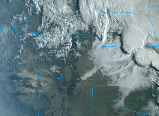
Taking a look at the visible satellite imagery below, you can see a few lingering showers from the passing shortwave overnight into this morning. This is producing some snow at the highest elevations, although it does not appear to be sticking to any of the roads. The early morning thunderstorms over the far northeast border counties are moving into Nebraska at this time. Overall, expecting a mild day in regards to temperature with clearing conditions as a ridge starts to build overhead. Residual moisture and a passing shortwave to our north may allow for a couple stray, weak thunderstorms to form this afternoon over the Northeast Plains and Palmer Ridge. With quick storm motion to the southeast, dew points in the high 40Fs, and very dry mid-levels, flooding is not expected. Some gusty outflow winds will be possible with the storms that do form.
Fire conditions will also return with a jet streak over central Colorado. These high winds are expected to mix downwards throughout the day and will cause breezy conditions statewide with the southern half of Colorado reaching critical fire weather. Over the eastern plains and western low elevations, afternoon wind speeds will be in the 15 to 25 mph range with gusts possibly 10 to 20 mph higher. Higher gusts are possible over the mountain passes. For the San Luis Valley and Southeast Mountains there will also be low relative humidity; thus, a Red Flag Warning has been issued. Don’t be too surprised if a Red Flag Warning is also be issued for portions of southwest Colorado later this afternoon, so please be sure to tune into your local NWS office for the latest.
Today’s Flood Threat Map
For more information on today’s flood threat, see the map below. If there is a threat, hover over the threat areas for more details, and click on burn areas to learn more about them. For Zone-Specific forecasts, scroll below the threat map.
Zone-Specific Forecasts:
Palmer Ridge, Front Range, Urban Corridor, Northeast Plains:
Showers are starting to break up and move eastward at this time. Expect some showers to continue over the highest terrains through early afternoon before the ridge begins to build. A couple stray, weak thunderstorms are possible this afternoon over the Northeast Plains and Palmer Ridge. Accumulations will be less than 0.5 inches, so flooding is not expected. Strong outflow winds and gusts up to 35 mph are possible with the jet overhead.
Primetime: 1PM to 7PM
Northern Mountains & Northwest Slope:
Highlighting these areas in their own discussion due to flows in area rivers, streams and creek continue to remain elevated or at bankfull conditions. Areas to watch closely for lowland flooding are the Elkhead Creek, upper Elk River, upper Slater Fork and other small streams in the upper Yampa Basin. Showers are expected to thin out as the day conditions with a couple lingering showers over the Northern Mountains. Isolated totals up to 0.15 inches will be possible by tomorrow morning. As for temperatures, forecasting seasonal highs this afternoon.
Primetime: 8AM to 6PM
Grand Valley, Southwest Slope, San Luis Valley, San Juan Mountains, Central Mountains, Southeast Plains, Raton Ridge, Southeast Mountains:
Expecting spotty Red Flag Warning criteria to be met over these regions this afternoon as temperatures remain warmer than northern Colorado. This is also due to low relative humidity as dry air fills in behind the departing shortwave from the west. Gusts up to 50 mph can be expected over the high, mountain passes with winds in the 15 to 25 mph range over the lower elevations. A weak cool front is expected to push south over the Southeast Plains later this evening. This may produce a few sprinkles, but more likely, just some cloud cover. Be sure to tune into your local NWS office for the latest on the critical fire weather.