Issue Date: 7/5/2015
Issue Time: 10:41 AM
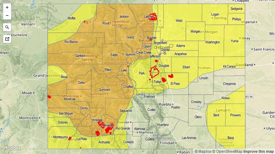
A MODERATE FLOOD THREAT HAS BEEN ISSUED FOR PORTIONS OF THE NORTHWEST SLOPE, NORTHERN MOUNTAINS, FRONT RANGE, CENTRAL MOUNTAINS, GRAND VALLEY, SOUTHWEST SLOPE, AND SAN JUAN MOUNTAINS. A LOW FLOOD THREAT HAS BEEN ISSUED FOR PORTIONS SURROUNDING THE HIGH COUNTRY MODERATE FLOOD THREATS, AS WELL AS PORTIONS OF THE URBAN CORRIDOR, PALMER RIDGE, NORTHEAST PLAINS, AND SOUTHEAST PLAINS.
This morning’s water vapor imagery is very useful in diagnosing the forecast for this period, so let’s break it down…
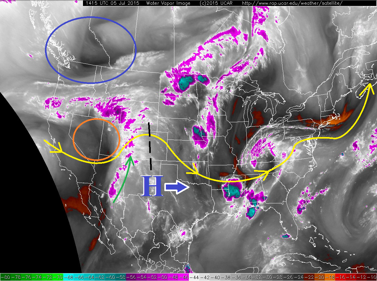
- The upper-level ridge (black dashed line) continues to flatten out and slide east in advance of a shortwave (circled in orange) moving across Utah and into western Colorado at this time.
- Ahead of this shortwave trough, subtropical moisture is streaming into the state. Precipitable water values have been pushed above 1 inch along the CO/UT border, and nearing 0.8-1.0 inches elsewhere. In fact, a new daily 12Z (6 AM) record has been set for Grand Junction, where 1.29 inches of precipitable water was observed. This is a deep, subtropical moisture plume. Monsoon season has arrived.
- A second wave, currently dropping out of British Columbia (circled in blue), will bring additional, large-scale forcing to Colorado this afternoon and evening. This will contribute to widespread showers and thunderstorms across northern portions of the High Country, namely the Northwest Slope, Northern Mountains, and Front Range, as well as scattered coverage across the Urban Corridor and Northeast Plains.
- Drier air will work in slowly from the west during evening hours (also circled in orange, associated with the backside of the first wave), bringing showers to an end from SW to NE across western Colorado. A few showers will persist over the higher terrain of the Northwest Slope and Northern Mountains into the early morning hours tomorrow, as those areas remain under weak forcing from the second wave.
Not noticeable on the water vapor imagery, but associated with the upper-level trough working across the northern United States, a cool front will work southward across Colorado, providing shallow, upslope flow to Eastern Colorado. This will continue the threat of isolated showers and thunderstorms into the overnight hours.
For more details on today’s forecast, please see the Zone-Specific Forecast discussions below the threat map.
Today’s Flood Threat Map
For more information on today’s flood threat, see the map below (hover over threat areas for more details). For Zone-Specific forecasts, jump below the map.

Zone-Specific Forecasts
Urban Corridor, Palmer Ridge, and Northeast Plains:
Scattered showers and thunderstorms expected this afternoon and evening, and stronger storms will produce periods of moderate-to-heavy rainfall. Maximum rain rates will be 0.8-1.2 inches/hour over the Urban Corridor, 1.0-1.4 inches/hour over the Palmer Ridge, and 1.0-1.6 inches/hour over the Northeast Plains. There is potential for one or two severe storms to develop over the far Northeast Plains, namely Sedgwick, Logan, Morgan, Washington, and Yuma counties; strong winds and large hail will be the main threats. Storm motions will help limit flooding concerns, but urban and low-lying areas will need to be monitored for localized flooding.
Timing: Noon – 9 PM, with a few showers and weak thunderstorms persisting into the early morning hours following cool frontal passage.
Southeast Plains and Raton Ridge:
Isolated-to-scattered showers and thunderstorms are expected this afternoon and evening as deep moisture continues to overspread the state. A thunderstorm or two will continue into the overnight hours across the Southeast Plains, mainly east of a North-South line following the Bent/Otero county boundary. Maximum rain rates will be 0.4-0.8 inches/hour from general showers/thunderstorms, with a stronger thunderstorm pushing 1.2-2.0 inches/hour.
Timing: 3 PM – 10 PM
Front Range, Northern Mountains, Northwest Slope, and Central Mountains:
Widespread showers and thunderstorms expected, with locally heavy rain and localized flooding a concern. With precipitable water values as high as they are, rain rates will generally be in the 0.6-1.0 inches/hour range, with maximum rates as high as 1.0-1.5 inches/hour. Storm motions will help limit flooding potential, but due to coverage and terrain, a moderate flood threat is warranted. The most activity and main threat period will occur during the afternoon and evening hours, but scattered showers will continue overnight.
Timing: 11 AM – 10 PM, but showers capable of moderate rainfall will continue overnight and into tomorrow morning.
San Luis Valley, Southeast Mountains, San Juan Mountains, Southwest Slope, and Grand Valley:
Widespread showers and thunderstorms expected over the San Juan Mountains, Southwest Slope, and Grand Valley, with more isolated-to-scattered coverage over the San Luis Valley and Southeast Mountains. Burn scars will warrant the most concern for flooding/debris slide/mudslide issues, but mudslides/localized flooding will be a concern for places that have received rainfall over the last few days. Maximum rain rates will be 0.4-0.8 inches/hour over the Southeast Mountains and San Luis Valley, with rates pushing 0.8-1.2 inches/hour over the San Juan Mountains, Southwest Slope, and Grand Valley. Showers and thunderstorms will come to an end from southwest to northeast later this evening as drier air works in from the west, but a few will persist over the higher terrain until midnight.
Timing: 11 AM – 10 PM