Issue Date: 5/3/2020
Issue Time: 8:00 AM
— NO FLOOD THREAT is forecast today
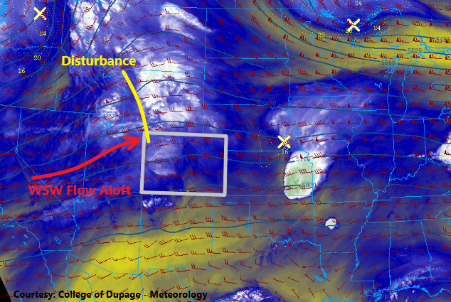
Northern Colorado and Southern Colorado are once again looking at two different weather stories today as the large-scale pattern has not changed much over the last 24-48 hours. Shown in the water vapor imagery below, west-southwest flow continues aloft, and embedded within this flow is a disturbance. This disturbance will travel across Wyoming today, but it will scrape across northern Colorado, providing the initiation for another round of afternoon/evening showers and thunderstorms for the following regions: Northwest Slope, Northern Mountains, Front Range, Urban Corridor, Northeast Plains, and Palmer Ridge. There will be fewer storms than yesterday thanks in part to the disturbance staying mainly north of the state. With that said, a couple will be strong-to-severe over the Urban Corridor, Palmer Ridge, and Northeast Plains regions, capable of producing hail up to 1 inch in diameter and wind gusts up to 65 mph.
For Southern Colorado, the story is much the same as the last few, with above-normal temperatures and dry and conditions expected. Elevated fire danger is a concern, with portions of the Grand Valley, Southwest Slope, San Juan Mountains, San Luis Valley, Southeast Mountains, Raton Ridge, and Southeast Plains regions. Please check with your local National Weather Service office for more information.
Today’s Flood Threat Map
For more information on today’s flood threat, see the map below. Hover over the threat areas for more details and click on burn areas to learn more about them. For Zone-Specific forecasts, scroll below the threat map.

Zone-Specific Forecasts
Northwest Slope and Northern Mountains:
Scattered showers/thunderstorms expected mainly this afternoon and evening, with the best coverage near the Wyoming border. A few showers/weak thunderstorms will continue into the overnight hours, with nearly all activity coming to an end by dawn tomorrow. Rain rates will generally be in the 0.1-0.3 inches/hour, with up to 0.2-0.5 inches/hour rain rates attending thunderstorms. Storm motions will be quickly to the east-northeast, so no flood threat is warranted.
Timing: Noon – 10 PM, with a few lingering showers/weak thunderstorms ending by dawn tomorrow.
NOTE: Minor lowland flooding from snowmelt may occur during the afternoon/evening hours tonight along low-lying areas of Elkhead Creek and Slater Fork Creek in Northeastern Moffat County and Northwestern Routt County.
Front Range, Urban Corridor, Palmer Ridge, and Northeast Plains:
Scattered showers/thunderstorms are expected once again this afternoon and evening, beginning around 1 PM over the Front Range, and spreading/developing eastward over the plains with time. A couple storms will be strong-to-marginally severe, capable of producing hail up to 1-inch in diameter and wind gusts up to 65 mph. Middling moisture below cloud bases will keep rain rates limited, especially over the Front Range and Urban Corridor, but slightly better moisture over the Northeast Plains and Palmer Ridge will be capable of producing heavier rainfall. Maximum rain rates are as follows:
Northeast Plains: 1-1.25 inches/hour
Palmer Ridge: 0.4-0.8 inches/hour
Urban Corridor: 0.3-0.6 inches/hour
Front Range: 0.2-0.4 inches/hour
Timing: 1 PM – 9 PM over the Front Range, with a few lingering showers/thunderstorms into the early morning hours; 2 PM – Midnight for the Urban Corridor, and Palmer Ridge, 2 PM – 3 AM for the Northeast Plains, with a couple lingering showers/storms until sunrise tomorrow.
Grand Valley, Central Mountains, Southwest Slope, San Juan Mountains, Southeast Mountains, San Luis Valley, Raton Ridge and Southeast Plains:
Hot and dry with gusty winds will be the main weather story, with elevated fire danger spread across the regions. Red Flag Warnings have been issued, so please check with your local National Weather Service office for more details.