Issue Date: 5/2/2020
Issue Time: 8:15 AM
— NO FLOOD THREAT is forecast today
It is a tale of two Colorado’s today, with the weather regimes split fairly nicely by Highway 50. South of Highway 50, it will be warm and dry, with elevated fire danger spread across the Southwest Slope, San Juan Mountains, San Luis Valley, Southeast Mountains, and Raton Ridge regions. Red Flag Warnings have been issued, so please check with your local National Weather Service office for more information.
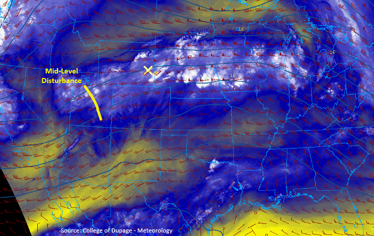
Along and north of Highway 50, a mid-level disturbance (shown by the yellow line in the image above) and decent moisture will combine to produce scattered showers and thunderstorms, beginning around lunchtime. The best coverage of storms will be across the Northwest Slope, Northern Mountains, Front Range, Urban Corridor, and Northeast Plains, with more widely scattered coverage as you move southward. A couple storms may become marginally severe over the Front Range, Urban Corridor, Palmer Divide, and adjacent plains areas, producing hail up to 1 inch in diameter and strong wind gusts up to 60 mph. Showers and storms will move generally west-to-east, ending over the mountains around sunset, and diminishing/exiting the state overnight across the plains. For more specific timing details, please see the zone-specific forecasts below.
Today’s Flood Threat Map
For more information on today’s flood threat, see the map below. Hover over the threat areas for more details and click on burn areas to learn more about them. For Zone-Specific forecasts, scroll below the threat map.

Zone-Specific Forecasts
Northwest Slope, Northern Mountains, Grand Valley, Central Mountains, and Front Range:
Scattered showers and thunderstorms are expected, beginning around 11 AM, and continuing into the evening hours. Surface moisture values are above average for the date, and they will provide the fuel for a couple stronger storms. Rain rates will generally be in the 0.1-0.3 inches/hour range, with up to 0.4-0.6 inches/hour with stronger storms. Storm motions will be fairly quick from west-to-east, precluding the issuance of any flood threat.
Timing: 11 AM – 9 PM, with primetime between 2 PM and 7 PM
Urban Corridor, Northeast Plains, Palmer Ridge, and Southeast Plains:
Scattered showers and thunderstorms are expected today, thanks to the combination of increased surface moisture and passing mid-level disturbance. The best coverage of storms will be along/north of I-70, with more widely scattered coverage to the south, becoming isolated across northern portions of the Southeast Plains.
A few storms will be on the strong-to-marginally severe side, mainly over the Front Range, Urban Corridor, and adjacent areas of the Palmer Ridge and Northeast Plains. The main threats from these stronger storms will be wind gusts up to 60 mph and hail up to 1 inch in diameter.
Rain rates will generally be in the 0.25 – 0.5 inches hour range, with the stronger storms producing rainfall up to 0.75 – 1.25 inches/hour. Storm motions will be fairly quick to the east, so no flood threat is warranted, but ponding in low-lying and/or poorly drained areas is expected under the stronger storms.
Timing: 1 PM – 10 PM for the Urban Corridor and Palmer Ridge, 2 PM – Midnight for the Plains.
Southwest Slope, San Juan Mountains, Southeast Mountains, San Luis Valley, and Raton Ridge:
Hot and dry with gusty winds will be the main weather story, with elevated fire danger spread across the regions. Red Flag Warnings have been issued, so please check with your local National Weather Service office for more details.