Issue Date: Thursday, September 19th, 2019
Issue Time: 8:30AM MDT
— A LOW flood threat has been issued for the 416/Burro burn area
Average to slightly above average low temperatures overnight across the state. There’s some dense, early morning fog being reported over the eastern plains near Limon out to the Kansas border (6:30AM MDT). This should quickly burn off with a little sunlight as the moisture is confined just to the surface. PW at Denver and Grand Junction was measured at 0.52 and 0.58 inches, respectively in this morning’s sounding. So not much change from yesterday. Expecting these values to increase over the next 24-hours from south to north, first over western Colorado with some really high values over eastern Colorado by tomorrow afternoon. This moisture surge has to do with the approaching low to our west. As the feature moves eastward and digs south throughout the day, upper level flow will turn from southwesterly to more southerly. This will allow a few disturbances to move through the flow and start to create a subtropical moisture surge (albeit weak).
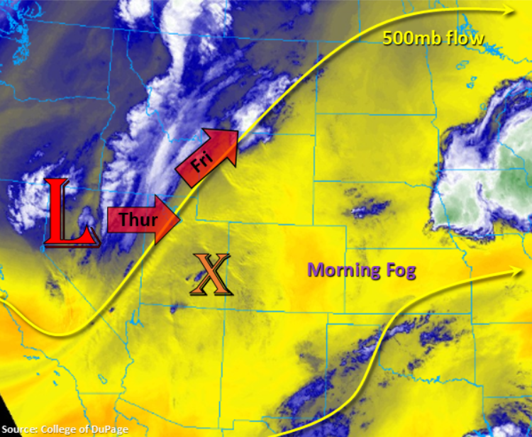
One of today’s disturbances is marked over Utah with the “X”. This feature will first move east this morning, and then it will pull northwards throughout the afternoon. Not expecting much rainfall with this feature due to the low PW values, but an increase in cloud cover should mark its location throughout the day. It may help spark some weak afternoon convection over the northern high terrains near and along the Continental Divide with the diurnal flow, but more virga than measurable rainfall is forecast. Over the eastern plains, along the CO/KS border, additional thunderstorms may be possible this afternoon. The latest model runs are keeping the stronger storms to the east of the border, but there is a good chance for an isolated storm or two initiating along the line of convergence over southeast Colorado (weak dryline). Not expecting flooding from these storms due to the isolated nature and the quick storm motion to the northeast.
Another disturbance moves from south to north this evening, which starts over western Colorado. With the increasing PW throughout the day, expecting some weak showers over the south Central and San Juan Mountains to begin later this evening. Storms will be capable of producing totals up to 0.9 inches over a 2-3 hour period over the San Juans (earlier timing of the moisture surge), so a Low flood threat has been issued for the 416 burn area. Rain rates should be gradual enough they won’t cause issues elsewhere. The coverage should expand over the high terrains overnight as the feature moves north. Some weak showers may also be possible over the Raton Ridge/southern Southeast Plains associated with another shortwave tomorrow morning. As it moves north throughout the morning, expect more cloud cover than measurable rainfall. Despite the numerous rounds of rainfall across the state (today, tonight, and tomorrow morning), flooding outside of the 416 burn scar, is not anticipated.
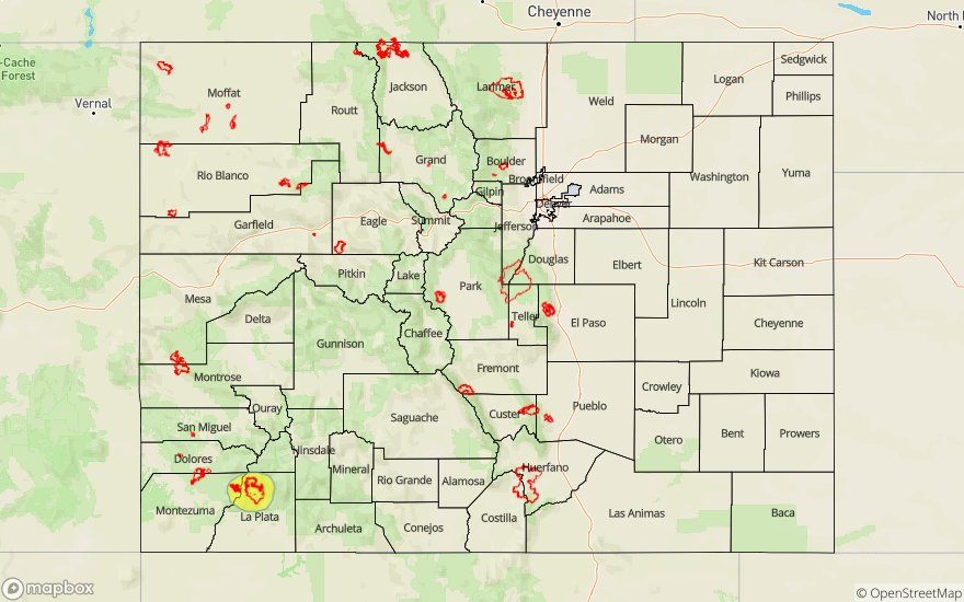
Today’s Flood Threat Map
For more information on today’s flood threat, see the map below. For Zone-Specific forecasts, scroll below the map.

Zone-Specific Forecasts:
Central Mountains, Northern Mountains, San Juan Mountains, Northwest Slope, Grand Valley, Southwest Slope, San Luis Valley:
Very isolated max 1-hour rain rates up to 0.75 inches with totals up to 0.9 inches by morning are possible over the San Juan Mountains with totals decreasing to 0.5 inches over the Central Mountains. The 1-hour rain rates are reduced to 0.35 inches as you move north into the Northern Mountains and Northwest Slope. Most of the rainfall will be along and near the Continental Divide this afternoon and evening with some isolated activity over the higher elevations of the North/Southwest Slopes. Lowest elevations should stay dry today minus the southern tier Southwest Slope and San Luis Valley. Isolated totals up to 0.25 inches will be possible by morning. Thunderstorms this afternoon will again be capable of producing some gusty outflow winds, but they should not be quite as strong as yesterday and Tuesday. If storms continues to track over the 416 burn area tonight, flash flooding of local streams, debris slides and mud flows will be possible due to the moisture surge arriving. A Low flood threat has been issued for this reason.
Primetime: 6PM to 5AM
Front Range, Southeast Mountains, Urban Corridor, Raton Ridge, Palmer Ridge, Southeast Plains, Northeast Plains:
Some afternoon convection will be possible over the Front Range near the Continental Divide, but accumulations should stay low (up to 0.25 inches). Overnight convection along the Divide may cause totals up to 0.4 inches over the Front Range by morning. Additional thunderstorms over the Southeast Plains this afternoon could have rain rates up to 1.1 inches with large hail and strong winds also possible. As showers move across the southern border early tomorrow morning, max 1-hour rain rates up to 0.5 inches will be possible. Flooding is not forecast due to the low intensity of storms and quick storm motion of the stronger storms to the NE this afternoon.
Primetime: 4PM to 7AM