Issue Date: Tuesday, September 17th, 2019
Issue Time: 9:05AM MDT
— Flooding is NOT expected today
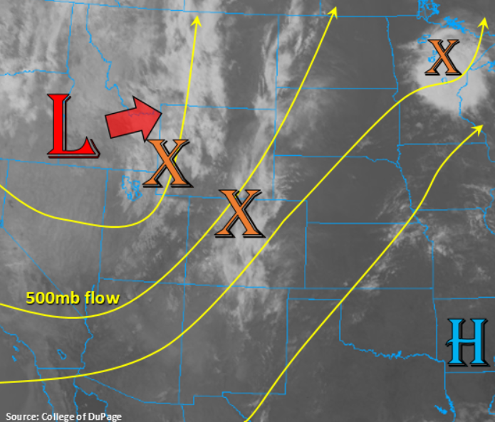
The aforementioned trough from yesterday’s FTB begins to move to the east-northeast over the next 24-hours, which will bring some mid-level energy and moisture over the state for another round of garden variety storms this afternoon and early evening. Currently, PW is at 0.73 inches over Grand Junction, which is helping produce some showers, and snow at the highest elevations, over the San Juan and Central Mountains. This is associated with the first shortwave marked in the infrared satellite imagery below (orange “X”). Expect the southwest flow aloft to turn more westerly as the trough progresses eastward, so PW values will really start to drop off this evening as the dry air mass is advected from the west. Also, the downsloping (westerly) winds will help scour out moisture over eastern Colorado. Thus, only expected one or two weak storms, tops, over the far Northeast Plains or Raton Ridge area associated with the passing shortwave. The more likely scenario is increasing cloud cover as the shortwave passes overhead with a sunshine starting to peek through this afternoon as the moisture is scoured out/moves east.
Over western Colorado, morning cloud cover and rainfall will limit the amount of instability that can form this afternoon, so only expecting a couple scattered, weak thunderstorms with mostly showers. A couple of the stronger storms may produce gusty outflow winds and small hail. Despite this morning’s precipitation, there will still be a slight increase in instability with the daytime heating, so forecasting showers to pick up a little in intensity and coverage this afternoon and early evening over the high terrains. Best chance for measurable rainfall will be over the San Juan, Central and Northern Mountains, but with fast storm motion, only expecting light to moderate accumulations where multiple storms can track over the same area. The lower elevations may see a sprinkle or two, but accumulations should remain under 0.1 inches. Due to the low intensity of the rain, flooding is not forecast.
Today’s Flood Threat Map
For more information on today’s flood threat, see the map below. For Zone-Specific forecasts, scroll below the map.
Zone-Specific Forecasts:
Central Mountains, Northern Mountains, San Juan Mountains, Northwest Slope, Southwest Slope, Grand Valley, San Luis Valley:
Very isolated max 1-hour rain rates up to 0.25 inches will be possible over the high terrains with no more than 0.1 inches per hour for the lower elevations today. Multiple storms tracking over the same area may cause very isolated accumulations up to 0.5 inches by morning over the highest elevations of the western Central and San Juan Mountains. Strong outflow winds are possible this afternoon with weak thunderstorms that are able to form, along with small hail. Despite decent accumulations of rainfall over the last couple of days, rain rates should still be gradual enough that flooding issues should be avoided. Dry air quickly fills in from the west this evening, which should end rainfall just after dark. Flooding is not forecast.
Primetime: Ongoing to 8PM
Front Range, Southeast Mountains, Raton Ridge, Southeast Plains, Northeast Plains, Palmer Ridge, Urban Corridor:
Downsloping winds will really limit the chances for rainfall this afternoon, so the best chance for accumulation will be along the Continental Divide. Expect an increase in cloud coverage as the shortwave passes overhead, which may help keep the high temperatures down a couple of ticks. A couple weak storms may be possible as the clouds/light rain move east over the far Northeast Plains and Raton Ridge, but rain rates should remain below 0.25 inches. Clouds will start to break up late this afternoon as dry air works in from the west, so it should be a pleasant evening. A weak cold front passes over the eastern plains overnight behind the trough, but it’s more of a wind shift than a temperature change. Nonetheless, high temperatures may drop a couple degrees tomorrow.
Primetime: 2PM to 8:30PM