Issue Date: 9/15/2019
Issue Time: 6:50 AM
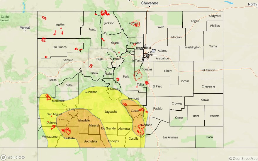
A MODERATE FLOOD THREAT HAS BEEN ISSUED FOR PORTIONS OF THE SAN JUAN MOUNTAINS, SOUTHWEST SLOPE, AND SOUTHEAST MOUNTAINS.
A LOW FLOOD THREAT HAS BEEN ISSUED FOR PORTIONS OF THE REGIONS ABOVE, AS WELL AS PORTIONS OF THE SAN LUIS VALLEY AND CENTRAL MOUNTAINS.
A subtropical disturbance, currently situated over AZ/NM will shift north/northeastward throughout the forecast period, bringing enhanced moisture and broad-scale lift to Colorado later today and tonight. The greatest impacts will be felt over the High Country and south of I-70, where the best moisture and support for thunderstorms will coincide. Precipitable water values will increase to 0.8-1.0 inches today/tonight over portions of the Southwest Slope, San Juan Mountains, and Southeast Mountains, and this amount of available moisture is the driver behind today’s moderate flood threat area. North of I-70, a few isolated storms will rumble, resulting in gusty winds and brief periods of rainfall.
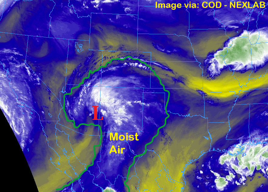
East of the mountains, the increase in mid-level moisture will result mainly in more cloud cover than the previous few days. A couple stray showers/thunderstorms will move off of the higher terrain late this afternoon and during the evening hours, mainly south of I-70, producing gusty winds and brief periods of light-to-moderate rainfall. Otherwise, it will be mostly sunny and warm again today. For more details on rain rates and timing, please see our zone-specific forecasts below.
Today’s Flood Threat Map
For more information on today’s flood threat, see the map below. For Zone-Specific forecasts, jump below the map.

Zone-Specific Forecasts
Urban Corridor, Northeast Plains, Southeast Plains, Palmer Ridge, and Raton Ridge:
Mostly sunny, warm, and dry for most, with only a few stray showers/thunderstorms possible for areas along/near the higher terrain and mainly south of I-70. Storm motions will be fairly quick to the north, mitigating the flash flood risk from heavy rainfall. With that said, street/field ponding is possible under the strongest storms. Maximum rain rates will be 0.6-1.0 inches/hour, with most likely rain rates below 0.5 inches/hour.
Timing: 3 PM – 11 PM
Front Range, Northern Mountains, and Northwest Slope:
A few more clouds than the last few days is expected as moisture streams into Colorado from the southwest. These regions will be furthest removed from broad-scale lift induced by the subtropical disturbance, so only a couple isolated showers/thunderstorms are expected late in the afternoon and into the nighttime hours. Rain rates will be below 0.3 inches/hour.
Timing: 4 PM – 11 PM
Southeast Mountains, San Luis Valley, San Juan Mountains, and Southwest Slope:
Scattered showers/thunderstorms will begin to move into the Southwest Slope and San Juan Mountains around lunchtime today, developing north/east with time. Peak thunderstorm activity will occur between 2 PM and 9 PM but expect scattered showers with a few embedded thunderstorms to continue into tomorrow morning. Most rain rates will be 0.2-0.4 inches/hour, but thunderstorms could produce rain rates up to 0.8-1.2 inches/hour. Storm motions will mitigate the flash flood risk somewhat, but a moderate flood threat is warranted, and burn scars deserve a close eye.
Timing: Noon – 10 AM tomorrow
Grand Valley and Central Mountains:
Mostly sunny to start, with clouds increasing just after lunchtime as moisture spreads in from the south. Most activity will be garden-variety, producing gusty winds and periods of light rainfall (less than 0.25 inches/hour), but a stronger storm will be possible over southern portions of the Central Mountains (up to 0.4-0.75 inches/hour), hence its inclusion in the low flood threat. A few isolated showers will continue into the early morning hours tomorrow, mainly over the higher terrain of the Central Mountains.
Timing: 2 PM – 6 AM