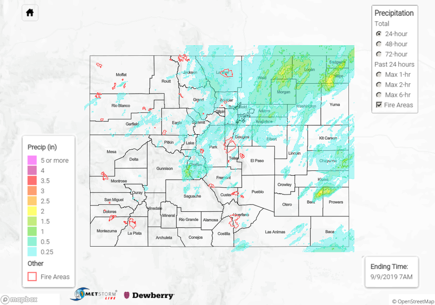
Issue Date: Monday, September 9th, 2019
Issue Time: 10:50AM MDT
Summary:
Moderate to heavy rainfall fell throughout the state yesterday as a shortwave trough moved over the state from the west. This feature brought in high levels of moisture to the northern and eastern portions of the state and provided upper level support for multiple rounds of severe thunderstorms. A few brief thunderstorms kicked things off over the Grand Valley, Southwest Slope and San Juan Mountains fairly early. Conditions were a little drier over these areas do to dry southwesterly surface flow which lead to lighter accumulations. CoCoRaHS stations reported widespread rain, but the highest report came in at only 0.13 inches for the Southwest Slope and San Juan Mountains.
Upper level moisture content and storm coverage increased to the north with multiple severe thunderstorm warnings issued throughout the northern Grand Valley, northern Central Mountains, Northwest Slope, and Northern Mountains. Most of these warnings were due to high thunderstorm wind gusts. Surface conditions were a little on the drier side, which lead to evaporative cooling and severe winds over the area. Notable reports to the NWS include:
–76 mph thunderstorm wind gust and 0.35 inch hail near Rifle in Garfield County
–69 mph thunderstorm wind gust near Massadona in Rio Blanco County
–61 mph thunderstorm wind gusts near Gypsum in Eagle County
Most of the rainfall for northern mountains fell over a 3 to 5 hour period as trailing storms continued to move over the area. Rainfall accumulations remained under 1 inch for the most part with a few isolated totals up to 1.03 inches over Routt and Eagle Counties. A RAWS station near Steamboat measured 0.72 inches over a 6 hour period.
Rainfall over the eastern mountains and eastern plains picked up significantly early yesterday afternoon as dew points in the 50°Fs and low 60°Fs pushed west towards the mountains. Heavy rainfall for the high country favored the Front Range with MetStorm estimating 1-hour rainfall rates up to 0.76 inches over Jefferson and Boulder Counties. CoCoRaHS stations measured 24-hour totals up to 0.71 inches over the Front Range and Urban Corridor. These are impressive amounts considering how quickly the storms were moving.
As storms moved off of the mountains, they quickly combined into a MCS that moved over the eastern plains throughout the afternoon and into the early morning. One system produced two tornadoes and wind gusts up to 68 mph over eastern Denver County and western Adams County respectively. 24-hour totals were on the high end throughout the Northeast Plains measuring from 1.78 inches to 2.59 inches from eastern Weld County to Phillips County. As outflow boundaries from the storms pushed to the south the spatial area of the storms extended well into the Southeast Plains. A Flash Flood Warning was issued early last night over Bent and Prowers County with heavy rainfall effecting highways 50 and 287, but no flooding was reported over the area as of this morning. CoCoRaHS stations in northern Prowers County measured up to 1.75 inches for the storm total. MetStorm estimated 1-hour rainfall rates up to 2.12 inches throughout the Northeast and Southeast Plains.
For a look at rainfall in your neighborhood, please visit the State Precipitation Map below.
Click Here For Map Overview
Note: The 24-hour, 48-hour and 72-hour total precipitation do not contain bias corrections today due to errors in the CoCoRaHS data. This means there may be underestimations in QPE over the southwest and southeast corners of the state.
