Issue Date: Saturday, September 7th, 2019
Issue Time: 10:25AM MDT
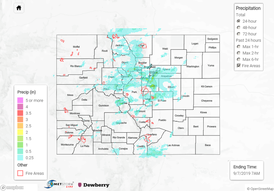
Summary:
It seemed like a cool, quiet weather day until storms really began to get going over the eastern mountains just after 2PM. A passing cloud front return a ton of low level moisture to the area, and slow steering winds helped allow for some very heavy accumulations. A strong thunderstorm formed over the southern foothills near Evergreen/Floyd Hill just after 1:30PM. Hail up to 1 inch in diameter was reported along with mud flows, debris slides and road flooding. Hail accumulated (inches in depth) on the roadways, which only exuberated the problem with the Cold Spring Gulch ALERT recording 1.14 inches. Storms also formed over the southern metro area and were nearly stationary. An incredible amount of rainfall ensued. An ALERT gauge in Centennial (Englewood Dam) had 2.72 inches of rain in an hour, which was truly a worst case scenario. That is the second highest gauge reading I’ve seen since I started watching those gages 3 years ago. To see 24-houir precipitation totals from the ALERT gages, click here: ALERT. Not surprisingly, there was a large area under a Flash Flood Warning during the afternoon commute with a car rescue at C-470 and Yosemite. Please don’t drive through high water. There was also a brief tornado reported near Centennial Airport and a tornado warning issued for Aurora briefly after for minor rotation in a storm. There was no tornado reported with this warning. Further south near the springs an ALERT gage recorded 1.93 inches near Perry Park. A USGS gage at Douglas Creek above Flying West Ranch Road had 1.61 inches with the USAF had 1.30 inches.
Flash Flood Warnings and Advisory was also issued for the Spring Creek and High Pass burn areas, respectively. Flooding was reported at Pass Creek Road (Spring Creek burn area), which is 3 miles north of Highway 160. There was CoCoRaHS station near Forbes Park that reported 0.8 inches for the 24-hour period. The Chalk Cliffs over Chaffee County also had a Flood Advisory issued for them at 2PM. MetStorm estimates up to 0.75 inches fell in the area with observations in the arear around 0.25 inches. As storms moved east, lack of instability and a capped environment kept the heavy rainfall threat away. Storms also picked up in intensity and coverage over the western high terrains. As much as 0.50 inches fell over the San Juan Mountains with two 0.4 inches observations near the Flat Tops.
To see estimated precipitation totals over your area on Friday, scroll down to the State Precipitation Map below.
Click Here For Map Overview
Note: The 24-hour, 48-hour and 72-hour total precipitation do not contain bias corrections today due to errors in the CoCoRaHS data. This means there may be underestimations in QPE over the southwest and southeast corners of the state.