Issue Date: Tuesday, September 3rd, 2019
Issue Time: 11AM MDT
–A LOW overnight flood threat has been issued for the Junkins, Hayden Pass and Spring Creek burn areas
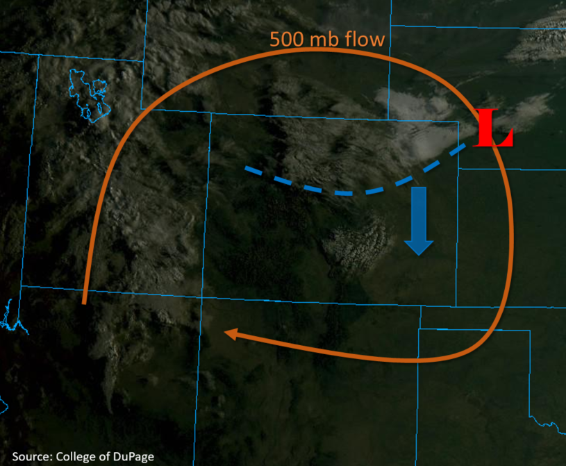
The ridge axis is slightly to our west today with the 500mb high anchored over the state, which will produce weak northwest flow over eastern Colorado and southwest/westerly flow over western Colorado. A passing trough will push a cold front (blue dashed line) through the state, and reduce high temperatures over the northern half of Colorado. As much as a 10°F to 15°F drop in high temperature from yesterday is expected over the Northeast Plains and Urban Corridor. Highs are expected to drop between 2°F and 4°F over western and southern Colorado where morning sunshine will allow temperatures to increase quickly again throughout the morning. As far as moisture goes, it remains low over Denver and Grand Junction this morning with PW measuring around 0.5 inches over both locations. Expecting an increase in moisture post frontal passage with some higher moisture sneaking into the southwest corner as well. Mid to upper level moisture and energy can be seen by the cloud cover over Utah, and is expected to move over Colorado on and off throughout the week (orange line below). Behind the front, post frontal upslope flow will continue to increase surface moisture with easterly flow at the surface.
The highest chances for precipitation today will be over the San Juan Mountains, Southeast Mountains, Central Mountains and the Front Range with the eastern plains remaining capped. Moisture behind the cold front will return dew points up to 60°F over and to the south of the southern Front Range. Residual surface moisture (40°F dew points) and incoming mid-level moisture will provide more wetting rainfall to the San Juan and Central Mountains today. Pockets of moderate instability will allow thunderstorms to initiate over the eastern mountain ranges this afternoon. Overnight, post frontal upslope flow continues over the Southeast Mountains, which will provide nearly continuous rain over the area until early tomorrow morning. A Low flood threat has been issued for the Junkins, Spring Creek and Hayden Pass Burn areas for precaution. Threats include debris flows, mud slides and flooding of small rivers and streams if this nearly stationary, overnight convection tracks overhead. Rainfall over dry soils elsewhere should be gradual enough that a Low flood threat is not needed outside of the burn areas.
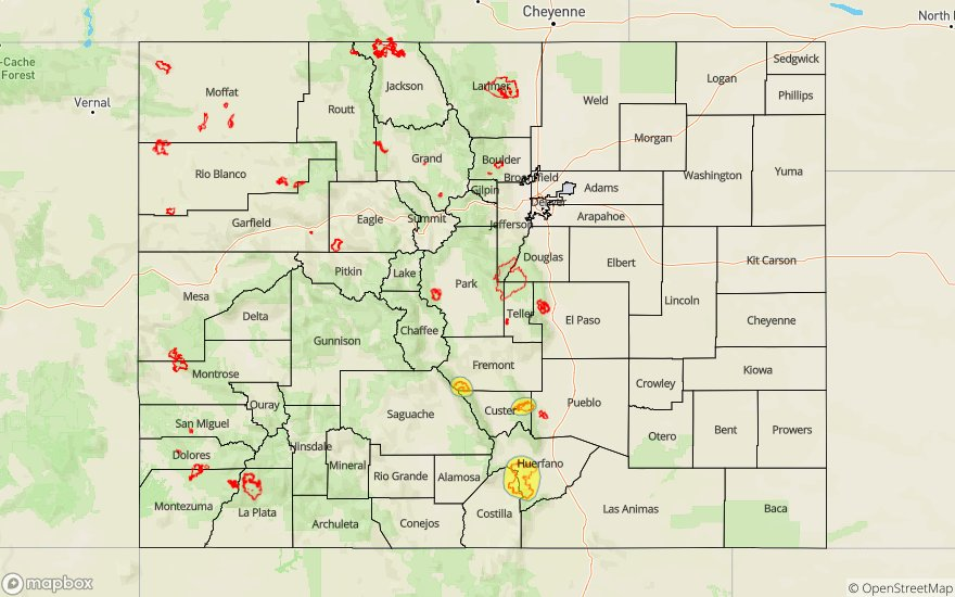
Today’s Flood Threat Map
For more information on today’s flood threat, see the map below. For Zone-Specific forecasts, scroll below the map.

Zone-Specific Forecasts:
San Juan Mountains, Southwest Slope, Central Mountains, Southeast Mountains, Front Range, Raton Ridge:
Afternoon thunderstorms are expected over these regions with storms extending into tomorrow morning over the Southeast Mountains. Isolated totals up to 0.1 inches are forecast over the San Juan Mountains, high elevations of the Southwest Slope and northern Front Range. Higher levels of moisture within the post frontal upslope flow area will increase chances of rainfall over the Central Mountains, Southern Front Range and Southeast Mountains. Isolated areas of max 1-hour rainfall rates up to 0.75 inches are forecast over Central Mountains, southern Front Range and Southeast Mountains for the rainfall overnight. Isolated storm totals up to 1.5 inches are possible over the Southeast Mountains with the overnight convection, and if the storms set up over the recent burn areas, flash flooding of local streams, debris slides and mud flows will be possible. This threat will extend until early tomorrow morning.
Primetime: 2PM to 4AM
Grand Valley, Northwest Slope, Northern Mountains, Northeast Plains, Palmer Ridge, Urban Corridor, Southeast Plains, San Luis Valley:
Most of the forecast area should remain dry today with a slight chance for a brief thunderstorm moving off of the mountains into the Urban Corridor and Raton Ridge. Isolated maximum 1-hour rainfall rates of 0.2 inches are forecast for these storms. The remaining areas of the region should remain dry with little to no chance for precipitation today. Afternoon cloud cover should decrease temperatures by 2°F-4°F over the western areas and by as much as 10°F to 15°F over the Northeast Plains, Urban Corridor and Palmer Ridge. Wind gusts up to 30 mph are possible over the eastern plains with the passage of the cold front this morning.
Primetime: 2PM to midnight